Henderson, Michigan facts for kids
Quick facts for kids
Henderson, Michigan
|
|
|---|---|

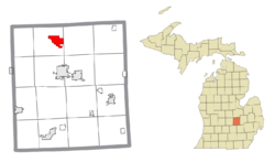
Location within Shiawassee County
|
|
| Country | United States |
| State | Michigan |
| County | Shiawassee |
| Township | Rush |
| Area | |
| • Total | 3.67 sq mi (9.49 km2) |
| • Land | 3.60 sq mi (9.32 km2) |
| • Water | 0.07 sq mi (0.17 km2) |
| Elevation | 732 ft (223 m) |
| Population
(2020)
|
|
| • Total | 413 |
| • Density | 114.72/sq mi (44.30/km2) |
| Time zone | UTC-5 (Eastern (EST)) |
| • Summer (DST) | UTC-4 (EDT) |
| ZIP code(s) |
48841
|
| Area code(s) | 989 |
| GNIS feature ID | 2628666 |
Henderson is a small community in Shiawassee County, located in the U.S. state of Michigan. It is known as an unincorporated community, meaning it doesn't have its own city government. It's also a special area called a census-designated place (CDP). This means it has officially defined borders and population numbers for government surveys.
In 2010, about 399 people lived in Henderson. By 2020, the population grew a little to 413 people. Henderson is part of Rush Township. The community was named after an early settler, John Henderson. It was once called Hendersonville and even Hazel Green.
Contents
History of Henderson, Michigan
Early Settlers and Development
The land where Henderson now stands was first claimed in 1836 by Gideon Lee from New York City. He later sold the land to Josiah Isham. In 1858, Andrew Henderson bought the land from Isham.
Andrew's son, John Henderson, is the person the community is named after. John was very important in building up the area. In 1868, he built the very first store in the community. A few years later, in 1875, he opened the first hotel. Because of his efforts, the community became known as Hendersonville.
Post Office and Official Recognition
The first post office in the area opened on May 14, 1868. It was called the Hazel Green post office, and William Cook was its first postmaster. The local train station for the Michigan Central Railroad was already named Henderson. To match the train station, the post office's name was changed to Henderson on October 16, 1876.
In 1879, Ezra Mason created a map, or "platted," the village for Andrew Henderson. This helped officially organize the community. Henderson was first listed as a census-designated place (CDP) for the 2010 census. This was the first time it had official borders and population statistics.
Geography of Henderson
Location and Waterways
Henderson covers an area of about 3.67 square miles (9.49 square kilometers). Most of this area, about 3.60 square miles (9.32 square kilometers), is land. A smaller part, about 0.07 square miles (0.17 square kilometers), is water.
The Shiawassee River flows right through the community. This river is an important natural feature of the area.
Nearby Roads
M-52, a state highway, forms part of Henderson's eastern border. This road helps connect Henderson to other nearby areas, including New Haven Township.
Population and People
How Many People Live Here?
The population of Henderson has been counted during the U.S. Decennial Census.
- In 2020, the population was 413 people.
Highways in Henderson
Main Road Access
 M-52 is a key highway that runs near or through Henderson, connecting it to other parts of Michigan.
See also
 In Spanish: Henderson (Míchigan) para niños
 | Emma Amos |
 | Edward Mitchell Bannister |
 | Larry D. Alexander |
 | Ernie Barnes |


