Henfield Rock facts for kids

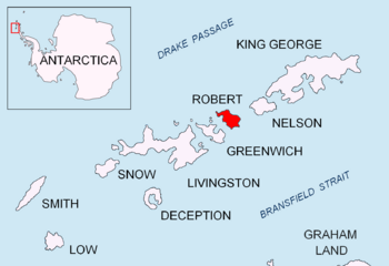
Location of Robert Island in the South Shetland Islands
|
|
|
Location of Henfield Rock
|
|
| Geography | |
|---|---|
| Location | Antarctica |
| Coordinates | 62°18′45.8″S 59°35′03.3″W / 62.312722°S 59.584250°W |
| Archipelago | South Shetland Islands |
| Administration | |
| Administered under the Antarctic Treaty System | |
| Demographics | |
| Population | Uninhabited |
Henfield Rock is a small rock in the ocean, located northwest of Robert Island in the South Shetland Islands. These islands are part of Antarctica.
People who hunted seals, called sealers, knew about this rock in the early 1800s. They worked from a nearby place called Clothier Harbour. Sometimes, Henfield Rock was even called 'Powels Islands' or 'Heywood Islands'.
The rock gets its name from Captain Joseph Henfield. He was the captain of an American ship named Catharina. His ship visited the South Shetland Islands between 1820 and 1821.
Where is Henfield Rock?
Henfield Rock is found in a specific spot in the South Shetland Islands. It is about 2.53 kilometers (1.57 miles) northeast of Catharina Point. It's also about 5 kilometers (3.1 miles) east of Heywood Island.
If you look south, it's only 700 meters (766 yards) from Opaka Rocks. And to the northwest, it's about 2.81 kilometers (1.75 miles) from Lientur Rocks. Different countries have mapped this area over the years, including Britain (in 1822 and 1968), Chile (in 1971), Argentina (in 1980), and Bulgaria (in 2009).
Maps of the Area
You can find Henfield Rock on detailed maps of Antarctica. One such map is:
- L.L. Ivanov. Antarctica: Livingston Island and Greenwich, Robert, Snow and Smith Islands. This is a topographic map with a scale of 1:120000. It was published in 2009 by the Manfred Wörner Foundation in Troyan. ISBN: 978-954-92032-6-4


