Lientur Rocks facts for kids

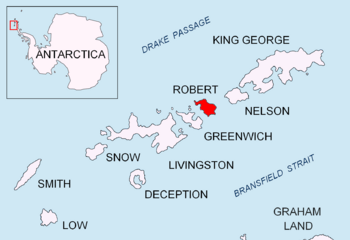
Location of Robert Island in the South Shetland Islands
|
|
| Geography | |
|---|---|
| Location | Antarctica |
| Coordinates | 62°19′36″S 59°31′55″W / 62.32667°S 59.53194°W |
| Archipelago | South Shetland Islands |
| Administration | |
| Administered under the Antarctic Treaty System | |
| Demographics | |
| Population | Uninhabited |
The Lientur Rocks are a group of rocks located near the north coast of Robert Island. Robert Island is part of the South Shetland Islands in Antarctica. These rocks stretch about 660 meters (2,165 feet) from east to west and 320 meters (1,050 feet) from north to south.
In the early 1800s, sealers often visited this area. They operated from a nearby place called Clothier Harbour. The name "Lientur" was given to these rocks by the Chilean Antarctic Expedition in 1949-50. It was named after their patrol ship, the Lientur.
Where are the Lientur Rocks?
The Lientur Rocks are found at coordinates 62°19′36″S 59°31′55″W. They are located:
- About 1.26 kilometers (0.78 miles) north-northwest of Newell Point.
- About 710 meters (776 yards) north-northeast of Tatul Island.
- About 3.12 kilometers (1.94 miles) southeast of Henfield Rock.
- About 3.41 kilometers (2.12 miles) southwest of Mellona Rocks.
- About 3.74 kilometers (2.32 miles) west-southwest of Liberty Rocks.
Different countries have mapped this area over the years. This includes British mapping in 1968, Chilean in 1971, Argentine in 1980, and Bulgarian in 2009.
Maps of the Area
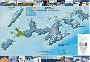
You can find the Lientur Rocks on detailed maps of the region. One such map is:
- L.L. Ivanov. Antarctica: Livingston Island and Greenwich, Robert, Snow and Smith Islands. This is a topographic map with a scale of 1:120000. It was published in 2009 by the Manfred Wörner Foundation. The ISBN for this map is ISBN: 978-954-92032-6-4.


