
Liberty Rocks facts for kids

Location of Nelson Strait in the South Shetland Islands
|
|

Liberty Rocks
Location in Antarctic Peninsula

Liberty Rocks
Location in Antarctica
|
|
| Geography | |
|---|---|
| Location | Antarctica |
| Coordinates | 62°18′50.6″S 59°27′44.2″W / 62.314056°S 59.462278°W |
| Archipelago | South Shetland Islands |
| Administration | |
| Administered under the Antarctic Treaty System | |
| Demographics | |
| Population | Uninhabited |
Liberty Rocks are a small group of four rocks located in a very cold place called Antarctica. They are found near the entrance of Nelson Strait, which is part of the South Shetland Islands. These rocks stretch out about 430 meters (1,410 feet) long and 120 meters (390 feet) wide.
Long ago, in the early 1800s, sailors who hunted seals visited this area. The rocks got their name from a British ship called Liberty. This ship, led by Captain Peacock, explored the South Shetland Islands in 1821 and 1822.
Where Are Liberty Rocks Located?
Liberty Rocks are centered at 62°18′50.6″S 59°27′44.2″W / 62.314056°S 59.462278°W. This spot is about 3.95 kilometers (2.45 miles) northeast of Newell Point on Robert Island.
They are also about 1.65 kilometers (1.03 miles) southeast of Mellona Rocks. If you travel about 11.38 kilometers (7.07 miles) west by south, you would reach Harmony Point on Nelson Island. Finally, Liberty Rocks are about 6 kilometers (3.7 miles) northwest of Makresh Rocks.
Many countries have mapped this area over the years. These include British maps from 1822, 1962, and 1968. Chilean maps were made in 1971, Argentine maps in 1980, and Bulgarian maps in 2009.
Images for kids
-
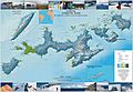
Topographic map showing Livingston Island, Greenwich, Robert, Snow, and Smith Islands. Liberty Rocks are located near Robert Island.

