Mellona Rocks facts for kids

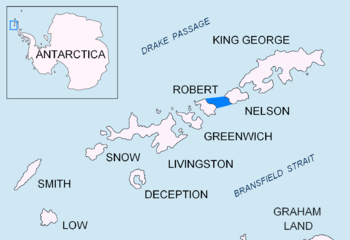
Nelson Strait
|
|
| Geography | |
|---|---|
| Location | Antarctica |
| Coordinates | 62°17′49.3″S 59°29′43.6″W / 62.297028°S 59.495444°W |
| Archipelago | South Shetland Islands |
| Administration | |
| Administered under the Antarctic Treaty System | |
| Demographics | |
| Population | Uninhabited |
The Mellona Rocks are a group of rocks found in Antarctica. They are scattered across the northern entrance of Nelson Strait. This area is part of the South Shetland Islands. The rocks stretch for about 1.7 kilometers (1.1 miles) by 0.9 kilometers (0.56 miles).
People who hunted seals in the early 1800s already knew about these rocks. Sometimes, they called them 'Heywood Islands' or 'Powels Islands'.
Naming the Mellona Rocks
These rocks got their name from a British ship called the Mellona. This ship was used for hunting seals. Captain Thomas Johnson was in charge of the Mellona. The ship worked in the South Shetlands during the years 1821 and 1822.
Where are the Mellona Rocks?
The center of the Mellona Rocks is located at 62°17′49.3″S 59°29′43.6″W / 62.297028°S 59.495444°W. They are quite close to other important places in the area:
- They are about 4.63 kilometers (2.88 miles) north-northeast of Newell Point. Newell Point is on Robert Island.
- They are also about 4.79 kilometers (2.98 miles) east-northeast of the middle of Opaka Rocks.
- The rocks are 13.1 kilometers (8.1 miles) west of Harmony Point. Harmony Point is on Nelson Island.
- And they are 2.35 kilometers (1.46 miles) northwest of Liberty Rocks.
Many different countries have mapped this area over the years. These include British maps from 1822, 1962, and 1968. Chilean maps were made in 1961 and 1971. Argentina mapped the area in 1980, and Bulgaria in 2009.
Maps of the Area
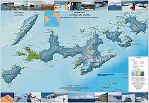
You can find the Mellona Rocks on detailed maps of Antarctica. For example, L.L. Ivanov created a topographic map in 2009. This map is called "Antarctica: Livingston Island and Greenwich, Robert, Snow and Smith Islands." It shows the landscape at a scale of 1:120000.


