Tatul Island facts for kids

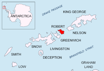
Location of Robert Island in the South Shetland Islands
|
|
|
Location of Tatul Island
|
|
| Geography | |
|---|---|
| Location | Antarctica |
| Coordinates | 62°20′03″S 59°32′22″W / 62.33417°S 59.53944°W |
| Archipelago | South Shetland Islands |
| Length | 0.35 km (0.217 mi) |
| Width | 0.2 km (0.12 mi) |
| Administration | |
| Administered under the Antarctic Treaty System | |
| Demographics | |
| Population | uninhabited |
Tatul Island is a small, triangular island located near Antarctica. It's a special place because it doesn't have ice on it. This island is found off the northern coast of Robert Island. Both islands are part of the South Shetland Islands.
Tatul Island is about 350 meters (1,150 feet) long and 200 meters (650 feet) wide. It became a separate island recently. This happened because the ice on Robert Island melted away. This melting occurred in the late 1900s and early 2000s.
The island got its name from a place in Bulgaria. Tatul is a settlement next to an ancient Thracian shrine. This shrine is in the Rhodope Mountains and is linked to the legend of Orpheus.
Where is Tatul Island Located?
Tatul Island is found in a very cold part of the world. Its exact spot is 62 degrees, 20 minutes, 3 seconds South and 59 degrees, 32 minutes, 22 seconds West.
It sits just 130 meters (425 feet) north of Robert Island. To its south-southwest, it's about 550 meters (1,800 feet) from Lientur Rocks. Also, it's about 950 meters (3,100 feet) west-northwest of Newell Point. Bulgarian explorers first mapped this area in 2009.
Maps of the Area
You can find Tatul Island on special maps of Antarctica. One important map is called "Antarctica: Livingston Island and Greenwich, Robert, Snow and Smith Islands." This map was made by L.L. Ivanov in 2009. It helps us see where Tatul Island is compared to other islands nearby.
- L.L. Ivanov. Antarctica: Livingston Island and Greenwich, Robert, Snow and Smith Islands. Scale 1:120000 topographic map. Troyan: Manfred Wörner Foundation, 2009. ISBN: 978-954-92032-6-4


