Henryville, Indiana facts for kids
Quick facts for kids
Henryville, Indiana
|
|
|---|---|

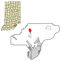
Location of Henryville in Clark County, Indiana.
|
|
| Country | United States |
| State | Indiana |
| County | Clark |
| Township | Monroe |
| Area | |
| • Total | 2.83 sq mi (7.33 km2) |
| • Land | 2.83 sq mi (7.32 km2) |
| • Water | 0.00 sq mi (0.01 km2) |
| Elevation | 495 ft (151 m) |
| Population
(2020)
|
|
| • Total | 1,878 |
| • Density | 664.78/sq mi (256.64/km2) |
| Time zone | UTC-5 (EST) |
| • Summer (DST) | UTC-4 (EDT) |
| ZIP code |
47126
|
| Area code(s) | 812 |
| FIPS code | 18-33142 |
| GNIS feature ID | 2393047 |
Henryville is a small community in Clark County, Indiana, in the United States. It's known as a census-designated place (CDP), which means it's a specific area identified by the census bureau. In 2020, about 1,878 people lived there.
Henryville is special because it's home to Clark State Forest, which is Indiana's oldest state forest. It's also the birthplace of some famous people. One is Colonel Harland Sanders, who started Kentucky Fried Chicken (KFC). Another is Michael Cleveland, a Grammy-winning bluegrass fiddle player.
Contents
History of Henryville
In 1850, this area was first called Morristown. A few years later, in 1853, its name was changed to Henryville. This was done to honor Colonel Henry Ferguson. He was a colonel in the Pennsylvania militia and bought the land where Henryville now stands. He also helped convince the Pennsylvania Railroad to build their train tracks through Clark County, which was a big deal for the town. The Henryville post office opened in 1865.
The 2012 Tornado
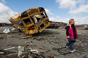
On March 2, 2012, Henryville was hit by a very powerful tornado. It was an EF4 tornado, which means it caused a lot of damage. The tornado was on the ground for over 50 miles. Sadly, one person died. The storm also destroyed the Henryville Elementary School and the Henryville Jr/Sr High School. It was a very difficult time for the community.
Geography and Climate
Henryville covers an area of about 2.9 square miles (7.3 square kilometers). All of this area is land.
Weather in Henryville
The weather in Henryville usually has hot and humid summers. The winters are generally mild to cool. This type of weather is known as a humid subtropical climate.
Population of Henryville
| Historical population | |||
|---|---|---|---|
| Census | Pop. | %± | |
| 2000 | 1,545 | — | |
| 2010 | 1,905 | 23.3% | |
| 2020 | 1,878 | −1.4% | |
| U.S. Decennial Census | |||
In 2000, there were 1,545 people living in Henryville. By 2010, the population grew to 1,905. In the most recent census in 2020, the population was 1,878.
Education in Henryville
Henryville has its own schools. There is an elementary school for younger students. There is also a junior/senior high school for older students.
The community also has a public library. It is a part of the Charlestown-Clark County Public Library system.
Transportation and Roads
Highways
Interstate 65 runs through the western part of Henryville. This major highway goes north and south. It runs close to an older road called U.S. Route 31. Another road, Indiana State Road 160, crosses both of these highways in Henryville.
Railroad
The Louisville & Indiana Railroad also passes through Henryville. Its tracks run north and south, similar to U.S. Route 31.
See also
 In Spanish: Henryville (Indiana) para niños
 | Calvin Brent |
 | Walter T. Bailey |
 | Martha Cassell Thompson |
 | Alberta Jeannette Cassell |


