
Heritage Range facts for kids
Quick facts for kids Heritage Range |
|
|---|---|
 |
|
| Dimensions | |
| Length | 160 km (99 mi) |
| Width | 48 km (30 mi) |
| Geography | |

Location in Antarctica
|
|
| Continent | Antarctica |
| State/Province | Ellsworth Land |
| Range coordinates | 79°45′S 83°00′W / 79.75°S 83°W |
| Parent range | Ellsworth Mountains |
| Borders on | Sentinel Range |
The Heritage Range is a huge group of mountains in Antarctica. It is about 160 kilometers (100 miles) long and 48 kilometers (30 miles) wide. This range is the southern part of the larger Ellsworth Mountains.
The Heritage Range has many different types of landforms. You can find scattered ridges, mountains, hills, and even nunataks. A nunatak is a rocky peak that sticks out of a glacier or ice sheet. Many glaciers flow between these different parts of the range.
Contents
Discovering the Heritage Range
The northern part of the Heritage Range was likely first seen by Lincoln Ellsworth. He flew over Antarctica on November 23, 1935.
Later, on December 14, 1959, a team saw the southern part of the range. Edward C. Thiel, J. C. Craddock, and E. S. Robinson were on a flight from Byrd Station. They even landed on a glacier in the range on December 26. This was near a place called Pipe Peak.
Mapping the Mountains
Scientists from the University of Minnesota explored the range in 1962–63 and 1963–64. They studied the geology and made maps.
The entire Heritage Range was later mapped by the USGS. They used aerial photos taken by the U.S. Navy between 1961 and 1966.
Why the Name "Heritage Range"?
The US-ACAN gave the range its name. They chose "Heritage Range" because many places within it are named after American heritage. This means the names often relate to important parts of American history or culture.
Maps
-
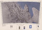
Map of the northern Heritage Range
-
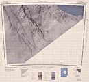
Map of the southern Heritage Range


Interesting Features
The Heritage Range is home to many unique geographical features. These include various peaks, ridges, and hills. Some of the notable areas are:
- Anderson Massif
- Douglas Peaks
- Dunbar Ridge
- Edson Hills
- Enterprise Hills
- Founders Peaks
- Frazier Ridge
- Gifford Peaks
- Independence Hills
- Liberty Hills
- Meyer Hills
- Pioneer Heights
- Soholt Peaks
- Watlack Hills
- Webers Peaks
There are also many other smaller features like:
- Barrett Nunataks
- Bingham Peak
- Cagle Peaks
- Carnell Peak
- Charles Peak
- Cunningham Peak
- Dott Ice Rise
- Driscoll Glacier
- Dybvadskog Peak
- Founders Escarpment
- Fusco Nunatak
- Gould Spur
- Gowan Glacier
- Hall Peak
- Hercules Inlet
- Herrin Peak
- High Nunatak
- Hoinkes Peak
- Hutto Peak
- Landmark Peak
- Linder Peak
- Matney Peak
- Mhire Spur
- Minnesota Glacier
- Mount Bursik
- Mount Johns
- Mount Rodger
- Mount Twiss
- Mount Woollard
- Navigator Peak
- Planck Point
- Robinson Peak
- Rutford Ice Stream
- Schneider Glacier
- Thompson Nunataks
- Three Sails
- Unger Peak
- Weaver Nunataks
- White Escarpment
- Wilson Nunataks
- Zavis Peak
See also
 In Spanish: Cordillera Heritage para niños
