Herron, Montana facts for kids
Quick facts for kids
Herron, Montana
|
|
|---|---|

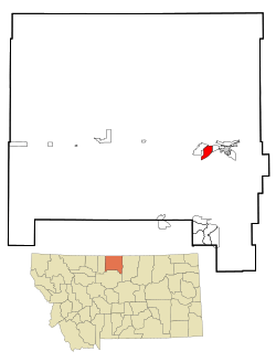
Location of Herron, Montana
|
|
| Country | United States |
| State | Montana |
| County | Hill |
| Area | |
| • Total | 4.68 sq mi (12.13 km2) |
| • Land | 4.68 sq mi (12.13 km2) |
| • Water | 0.00 sq mi (0.00 km2) |
| Elevation | 2,602 ft (793 m) |
| Population
(2020)
|
|
| • Total | 88 |
| • Density | 18.80/sq mi (7.26/km2) |
| Time zone | UTC-7 (Mountain (MST)) |
| • Summer (DST) | UTC-6 (MDT) |
| Area code(s) | 406 |
| FIPS code | 30-35912 |
| GNIS feature ID | 1853178 |
Herron is a small community in Hill County, Montana, in the United States. It is known as a census-designated place (CDP). This means it's an area that the government counts for population, but it's not officially a city or town. In 2020, 88 people lived in Herron.
Contents
Exploring Herron's Location
Herron is located in the eastern part of Hill County. Its exact location is 48.514344 degrees north and -109.788942 degrees west.
Nearby Places and Roads
Herron is surrounded by other communities. To its east is West Havre. To its west, you'll find Beaver Creek.
Two main roads are important for Herron:
- U.S. Route 2 runs along the northern edge of Herron. This road goes east about 4 miles (6.4 km) to Havre, which is the main town of the county. It also goes west about 25 miles (40 km) to Gildford.
- U.S. Route 87 forms the eastern and southeastern borders of Herron. This road ends at U.S. Route 2. If you go south on U.S. Route 87, you'll reach Box Elder in about 20 miles (32 km).
Herron's Airport
The Havre City–County Airport is located within the northern part of Herron. This airport helps connect the community to other places.
Land Area of Herron
According to the United States Census Bureau, Herron covers a total area of about 4.68 square miles (12.1 square kilometers). All of this area is land, meaning there are no large bodies of water within its boundaries.
Understanding Herron's Population
The population of Herron has changed over the years. Here's a quick look at how many people have lived there:
| Historical population | |||
|---|---|---|---|
| Census | Pop. | %± | |
| 2020 | 88 | — | |
| U.S. Decennial Census | |||
People and Households in 2000
In the year 2000, there were 100 people living in Herron. These people lived in 43 different homes, and 34 of these were families. The area had about 21.4 people per square mile (8.3 people per square kilometer).
Most of the people living in Herron in 2000 were White (95%). A smaller number were Native American (3%), and 2% were from two or more racial backgrounds.
Family Life in Herron
Out of the 43 homes in 2000:
- About 23% had children under 18 living there.
- Most homes (65%) were married couples living together.
- About 12% had a female head of household with no husband present.
- About 21% were not families.
The average home had 2.33 people, and the average family had 2.56 people.
Age Groups in Herron
In 2000, the population of Herron was spread out across different age groups:
- 17% were under 18 years old.
- 6% were between 18 and 24 years old.
- 22% were between 25 and 44 years old.
- 36% were between 45 and 64 years old.
- 19% were 65 years or older.
The average age of people in Herron in 2000 was 48 years. For every 100 females, there were about 104 males.
See also
 In Spanish: Herron (Montana) para niños

