Hershey, Nebraska facts for kids
Quick facts for kids
Hershey, Nebraska
|
|
|---|---|
|
Village
|
|

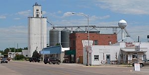
Downtown Hershey
|
|

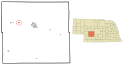
Location of Hershey, Nebraska
|
|
| Country | United States |
| State | Nebraska |
| County | Lincoln |
| Area | |
| • Total | 0.76 sq mi (1.98 km2) |
| • Land | 0.76 sq mi (1.98 km2) |
| • Water | 0.00 sq mi (0.00 km2) |
| Elevation | 2,900 ft (900 m) |
| Population
(2020)
|
|
| • Total | 649 |
| • Density | 850.59/sq mi (328.30/km2) |
| Time zone | UTC-6 (Central (CST)) |
| • Summer (DST) | UTC-5 (CDT) |
| ZIP code |
69143
|
| Area code(s) | 308 |
| FIPS code | 31-22290 |
| GNIS feature ID | 2398496 |
Hershey is a small village located in Lincoln County, Nebraska, in the United States. It is part of the North Platte, Nebraska Micropolitan Statistical Area. In 2020, about 649 people lived there.
Contents
History of Hershey
How Hershey Began
Hershey started as a stop along the Union Pacific Railroad. It was named after J. H. Hershey, one of the first people to settle in the area. The village was officially planned out on February 5, 1892, by Annie S. Guthrie.
Hershey in the Early 1900s
By 1900, Hershey was home to about 80 people. It had important businesses like a blacksmith, merchants, and a doctor. There were also many farm families living nearby. The village officially became a town in April 1909.
Growing Years: 1900 to 1920
Between 1900 and 1920, Hershey grew a lot! It became an important center for the surrounding farms. A local newspaper, the Hershey Times, started in 1911. The village also got public water and electric lights in 1913, and a telephone system in 1914.
Many new businesses opened, including mills, banks, a hotel, and car dealerships. There were also three churches: Methodist, Presbyterian, and Lutheran. People could join groups like the Odd Fellows and Modern Woodmen of the World.
Farming in Hershey
Hershey is in a great spot for farming, between the North and South Platte rivers. Farmers grew crops like alfalfa and sugar beets. Raising animals was also very important. In 1919, Hershey shipped out many train carloads of hay and sugar beets.
New Families Arrive
The railroad and sugar beet farms needed many workers. This brought new groups of immigrants to Hershey. These included Russian Germans, Japanese, and Mexican families. They became important parts of the community, working hard and building new lives.
Geography and Climate
Where Hershey is Located
Hershey is located on the Union Pacific Railroad's Overland Route. This is a major train route. The village covers about 0.61 square miles (1.58 square kilometers) of land.
Hershey's Weather
Hershey has a climate with warm summers and cold winters. The hottest month is usually July, and the coldest is January. The area gets some snow in winter and more rain in spring and summer.
| Climate data for Hershey 5 SSE, Nebraska (1991–2020 normals, extremes 1965–present) | |||||||||||||
|---|---|---|---|---|---|---|---|---|---|---|---|---|---|
| Month | Jan | Feb | Mar | Apr | May | Jun | Jul | Aug | Sep | Oct | Nov | Dec | Year |
| Record high °F (°C) | 74 (23) |
80 (27) |
90 (32) |
95 (35) |
100 (38) |
110 (43) |
110 (43) |
109 (43) |
104 (40) |
94 (34) |
86 (30) |
75 (24) |
110 (43) |
| Mean maximum °F (°C) | 61.2 (16.2) |
66.4 (19.1) |
76.9 (24.9) |
84.8 (29.3) |
90.8 (32.7) |
96.7 (35.9) |
100.3 (37.9) |
98.1 (36.7) |
95.3 (35.2) |
87.3 (30.7) |
74.3 (23.5) |
63.6 (17.6) |
101.5 (38.6) |
| Mean daily maximum °F (°C) | 38.9 (3.8) |
42.0 (5.6) |
52.8 (11.6) |
61.5 (16.4) |
71.4 (21.9) |
82.5 (28.1) |
88.3 (31.3) |
86.5 (30.3) |
79.1 (26.2) |
65.4 (18.6) |
51.4 (10.8) |
40.5 (4.7) |
63.4 (17.4) |
| Daily mean °F (°C) | 26.6 (−3.0) |
29.3 (−1.5) |
38.6 (3.7) |
47.2 (8.4) |
57.8 (14.3) |
68.6 (20.3) |
74.3 (23.5) |
72.4 (22.4) |
64.0 (17.8) |
50.5 (10.3) |
37.7 (3.2) |
28.1 (−2.2) |
49.6 (9.8) |
| Mean daily minimum °F (°C) | 14.4 (−9.8) |
16.5 (−8.6) |
24.3 (−4.3) |
33.0 (0.6) |
44.1 (6.7) |
54.8 (12.7) |
60.4 (15.8) |
58.3 (14.6) |
48.8 (9.3) |
35.7 (2.1) |
23.9 (−4.5) |
15.7 (−9.1) |
35.8 (2.1) |
| Mean minimum °F (°C) | −6.0 (−21.1) |
−2.1 (−18.9) |
6.5 (−14.2) |
19.0 (−7.2) |
31.4 (−0.3) |
43.8 (6.6) |
51.7 (10.9) |
49.2 (9.6) |
35.3 (1.8) |
19.7 (−6.8) |
7.9 (−13.4) |
−2.1 (−18.9) |
−10.8 (−23.8) |
| Record low °F (°C) | −23 (−31) |
−27 (−33) |
−15 (−26) |
5 (−15) |
23 (−5) |
28 (−2) |
42 (6) |
41 (5) |
22 (−6) |
2 (−17) |
−7 (−22) |
−31 (−35) |
−31 (−35) |
| Average precipitation inches (mm) | 0.23 (5.8) |
0.43 (11) |
0.85 (22) |
1.99 (51) |
3.33 (85) |
3.82 (97) |
2.68 (68) |
2.21 (56) |
1.58 (40) |
1.79 (45) |
0.38 (9.7) |
0.29 (7.4) |
19.58 (497) |
| Average snowfall inches (cm) | 3.7 (9.4) |
6.3 (16) |
4.0 (10) |
4.0 (10) |
0.1 (0.25) |
0.0 (0.0) |
0.0 (0.0) |
0.0 (0.0) |
0.1 (0.25) |
1.6 (4.1) |
2.2 (5.6) |
4.9 (12) |
26.9 (68) |
| Average precipitation days (≥ 0.01 in) | 3.0 | 4.2 | 5.1 | 7.5 | 10.1 | 9.3 | 8.1 | 6.2 | 5.8 | 5.6 | 3.2 | 3.1 | 71.2 |
| Average snowy days (≥ 0.1 in) | 2.8 | 3.6 | 2.3 | 1.7 | 0.0 | 0.0 | 0.0 | 0.0 | 0.0 | 0.7 | 1.6 | 2.6 | 15.3 |
| Source: NOAA | |||||||||||||
People of Hershey
Population Changes Over Time
The number of people living in Hershey has changed over the years. Here's how the population has grown and shrunk:
| Historical population | |||
|---|---|---|---|
| Census | Pop. | %± | |
| 1910 | 332 | — | |
| 1920 | 482 | 45.2% | |
| 1930 | 473 | −1.9% | |
| 1940 | 487 | 3.0% | |
| 1950 | 573 | 17.7% | |
| 1960 | 504 | −12.0% | |
| 1970 | 526 | 4.4% | |
| 1980 | 633 | 20.3% | |
| 1990 | 579 | −8.5% | |
| 2000 | 572 | −1.2% | |
| 2010 | 665 | 16.3% | |
| 2020 | 649 | −2.4% | |
| U.S. Decennial Census | |||
Hershey's Community in 2010
In 2010, there were 665 people living in Hershey. Most people were White, but there were also African American, Native American, and Asian residents. About 8.9% of the population was Hispanic or Latino.
Many households had children under 18. The average age in the village was about 40.6 years old.
Famous People from Hershey
- Ben Kuroki
- Walt Golvin, a baseball player
See also
 In Spanish: Hershey (Nebraska) para niños
 | George Robert Carruthers |
 | Patricia Bath |
 | Jan Ernst Matzeliger |
 | Alexander Miles |

