Hikurangi Plateau facts for kids

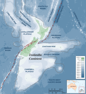
The Hikurangi Plateau is a huge, flat area of the seafloor. It's located in the South Pacific Ocean, just east of New Zealand's North Island. This plateau is like a giant, ancient volcanic region. It formed from massive lava flows, similar to the Manihiki and Ontong Java plateaus. These three areas were once connected, but they are now thousands of kilometers apart. The plateau gets its name from Mount Hikurangi. In Māori mythology, this mountain was the first part of the North Island to rise from the ocean.
Contents
What is the Hikurangi Plateau?
The Hikurangi Plateau covers about 400,000 square kilometers. That's a huge area, roughly the size of Japan! It lies deep underwater, between 2,500 and 3,000 meters below the sea surface.
The Hikurangi Channel
A long underwater valley, called the Hikurangi Channel, cuts across the plateau. This channel is about 2,000 kilometers long. It starts near Kaikōura and follows the Hikurangi Trench. Then it crosses the plateau before ending in the deep South-west Pacific Ocean.
How the Hikurangi Plateau Formed
Scientists have two main ideas about how the Hikurangi Plateau was created.
Idea 1: Gondwana Break-up
One idea is that it formed when the ancient supercontinent Gondwana broke apart. This happened about 107 million years ago. A huge plume of hot rock from deep inside the Earth might have caused this. This plume also led to Zealandia separating from Antarctica.
Idea 2: The Mega-Plateau Event
The second idea suggests that Hikurangi formed much earlier, around 120 million years ago. It might have been part of a massive "mega-plateau." This mega-plateau included the Ontong Java and Manihiki plateaus. If this is true, the Hikurangi Plateau must have moved thousands of kilometers. It drifted during a time called the Cretaceous silent period (84–121 million years ago). Eventually, it collided with Gondwana.
Evidence for the Mega-Plateau
A study from 2010 supported the mega-plateau idea. This study found evidence that other underwater areas were also part of this huge volcanic event. These areas include parts of the Central Pacific, Nauru, East Mariana, and Lyra basins. This ancient volcanic activity was enormous. It might have covered 1% of Earth's surface! Such a massive event would have had a big impact on life on Earth at that time.
However, there are also signs of a second, later volcanic event on Hikurangi. This happened during the Late Cretaceous period. It was linked to more volcanic activity in New Zealand. This second event was part of the final break-up of Gondwana.
Hikurangi Plateau and New Zealand's Geology
Parts of the Hikurangi Plateau have been pushed under other landmasses. This process is called subduction.
Subduction Under Chatham Rise
The plateau was partly subducted under the Chatham Rise. This likely happened during the Cretaceous period. It probably created a slab of rock more than 150 kilometers long underground.
Subduction Under North Island
The western edge of the plateau is actively being pushed under the North Island of New Zealand. It goes down to a depth of about 65 kilometers. If we add these missing, subducted parts back, the Hikurangi Plateau was originally much larger. It would have covered about 800,000 square kilometers. This is similar in size to the Manihiki Plateau.
The Hikurangi Plateau first went under New Zealand about 100 million years ago. This happened during the Gondwana collision. Now, it's subducting a second time. This is because the Pacific and Australian plates are moving towards each other. These subducted parts reach deep into the Earth's mantle. They go between 37 and 140 kilometers beneath the North Island and northern South Island.
The large size of the Hikurangi Plateau's underground slab is important. It has played a big role in the geology of New Zealand for the past 100 million years. For example, the Southern Alps in the central South Island are rising up. This uplift happens along the plate boundary. This boundary runs parallel to the western edge of the Hikurangi Plateau's slab.
Earthquakes and the Plateau
The Australian and Pacific plates meet in a complex zone. This zone includes the Tonga-Kermadec-Hikurangi subduction zone. The Hikurangi Plateau changes how this subduction works under the North Island. At the Hikurangi subduction zone, the plateau is quite buoyant (it floats well). This buoyancy has caused a part of the seafloor to be exposed. This can lead to strong earthquakes, like the 7.8 Mw 1931 Hawke's Bay earthquake.
 | Aurelia Browder |
 | Nannie Helen Burroughs |
 | Michelle Alexander |

