Ontong Java Plateau facts for kids
Quick facts for kids Ontong Java PlateauStratigraphic range: Cretaceous 125–90Ma |
|
|---|---|
| Type | Igneous |
| Area | 1.5 million km2 (580,000 sq mi) |
| Lithology | |
| Primary | Basalt |
| Location | |
| Coordinates | 3°03′S 160°23′E / 3.050°S 160.383°E |
| Region | South Pacific Ocean |
| Type section | |
| Named for | Ontong Java Atoll |
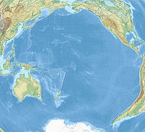
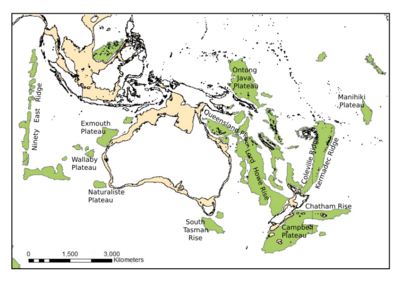
The Ontong Java Plateau (OJP) is a huge underwater landscape made of volcanic rock, known as an oceanic plateau. It is located in the southwestern Pacific Ocean, just north of the Solomon Islands.
This massive plateau was formed by intense volcanic activity about 116 million years ago. Scientists believe it was once part of an even larger feature, along with the Manihiki and Hikurangi plateaus. Together, this super-plateau would have covered 1% of the Earth's surface with lava.
The creation of the Ontong Java Plateau was the largest volcanic event in the last 200 million years. For about 3 million years, it released an incredible amount of magma (melted rock). The total amount of lava was several times larger than other famous volcanic events, like the ones that formed the Deccan Traps in India.
Today, the plateau's mostly smooth surface is dotted with underwater mountains called seamounts. One of these, the Ontong Java Atoll, pokes above the ocean surface and is one of the largest atolls in the world.
What is the Ontong Java Plateau?
The Ontong Java Plateau is enormous, covering an area of about 1.5 million square kilometers. That's roughly the size of Alaska! Most of it lies deep underwater, between 2,000 and 3,000 meters below sea level.
It is an incredibly thick and solid piece of the Earth's crust. While the crust under the ocean is usually about 7 kilometers thick, the Ontong Java Plateau is estimated to be up to 36 kilometers thick. It is made almost entirely of a dark volcanic rock called basalt.
How Did This Giant Plateau Form?
The Ontong Java Plateau formed very quickly from a geological feature called a mantle plume. You can think of a mantle plume as a giant blowtorch of super-hot rock rising from deep within the Earth. When this plume reached the surface, it melted and poured out massive amounts of lava, which cooled and hardened to build the plateau.
This plume is likely the same one that created the Louisville hotspot, a volcanic area that is still active today. After the main eruption that built the plateau, smaller volcanic events continued for millions of years.
A Slow-Motion Collision
For millions of years, the Ontong Java Plateau has been slowly moving across the ocean floor, carried by the massive Pacific Plate. This movement has caused it to collide with the nearby Solomon Islands.
Because the plateau is so thick and strong, it cannot easily slide under the other tectonic plate (a process called subduction). Instead, the collision is pushing up the land and has helped form many of the Solomon Islands.
This powerful geological process, called uplift, has raised parts of the ancient plateau more than 2,000 meters above sea level. Islands like Guadalcanal, Makira, and Malaita are actually pieces of the seafloor and the plateau that have been pushed up by this incredible collision. The crash also created new volcanoes, which formed other islands like New Georgia and Bougainville Island.
 | William Lucy |
 | Charles Hayes |
 | Cleveland Robinson |


