Manihiki Plateau facts for kids
Quick facts for kids Manihiki PlateauStratigraphic range: Cretaceous 126–116Ma |
|
|---|---|
| Type | Igneous |
| Area | 770,000 km2 (300,000 sq mi) |
| Lithology | |
| Primary | Basalt |
| Location | |
| Coordinates | 10°00′S 162°30′W / 10°S 162.5°W |
| Region | South Pacific Ocean |
| Country | Cook Islands |
| Type section | |
| Named for | Manihiki atoll |

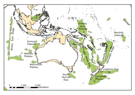
The Manihiki Plateau is a huge, flat area found deep under the water in the southwest Pacific Ocean. Think of it like a giant underwater table! This massive plateau was created by powerful volcanic eruptions between 126 and 116 million years ago. This was during a time called the Cretaceous period, when dinosaurs roamed the Earth. The Manihiki Plateau formed where three tectonic plates met, a special spot called the Tongareva triple junction. Long, long ago, about 125 million years ago, the Manihiki Plateau was actually part of an even bigger underwater landform. It was connected to two other huge plateaus, forming what scientists call the Ontong Java-Manihiki-Hikurangi super plateau.
Exploring the Manihiki Plateau
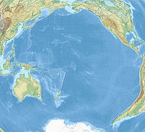
The Manihiki Plateau is located in the vast Pacific Ocean, stretching from about 3°S to 6°S latitude and 159°W to 169°W longitude. It covers a huge area of about 770,000 square kilometers. That's roughly the size of a country like Turkey! This massive underwater feature has an estimated volume of 8.8 million cubic kilometers. Its crust, the Earth's outer layer, is also quite thick, ranging from 15 to 25 kilometers.
Several beautiful Cook Islands sit on the southern part of this plateau. These include Pukapuka, Nassau, Suwarrow, Rakahanga, and Manihiki. The plateau is surrounded by deep ocean areas called basins. To its west is the Tokelau Basin, to the south is the Samoan Basin, to the east is the Penrhyn Basin, and to the north is the Central Pacific Basin.
The top of the Manihiki Plateau is much shallower than the deep ocean floor around it. It lies about 2.5 to 3 kilometers below sea level. This is several kilometers higher than the surrounding ocean basins. Scientists divide the plateau into three main parts:
- The High Plateau: This is the largest and flattest part, found in the southeast. It's also the shallowest. Its base is covered by up to a kilometer of soft, muddy sedimentary rock that settled from the ocean water over millions of years.
- The Western Plateaus: Located northwest of the High Plateau, these are a series of underwater ridges and seamounts, which are like underwater mountains.
- The North Plateau: This is a smaller section, almost separated from the rest of the Manihiki Plateau.
The High Plateau alone covers about 400,000 square kilometers. The Western Plateaus cover about 250,000 square kilometers, and the North Plateau covers about 60,000 square kilometers. These different parts of the plateau are separated by what scientists call "failed rifts." These are places where the Earth's crust started to pull apart, but then stopped before fully splitting.
How the Manihiki Plateau Formed
For a long time, scientists thought the Manihiki Plateau might have been a small continent that sank deep into the ocean. But in the 1970s, special drilling projects showed that it is actually made of oceanic crust, the type of rock that forms the ocean floor.
The plateau was created by a period of intense volcanic activity during the Early Cretaceous period. Imagine huge amounts of molten rock, called magma, erupting from deep within the Earth! This happened because of a combination of factors. There was a "hotspot," which is like a super-hot plume of rock rising from the Earth's mantle. Also, areas where new ocean floor was being created, called mid-ocean ridges, moved around a lot. All this activity led to the formation of a "large igneous province," which is a fancy name for a massive area covered by volcanic rock.
Scientists have studied rock samples from the Manihiki Plateau. These samples show that the main volcanic activity happened between 126 and 116 million years ago. At that time, the Manihiki Plateau was part of the largest volcanic rock area on Earth, more than twice its current size! This giant area included the Ontong Java, Manihiki, and Hikurangi plateaus all connected together.
Around 125 million years ago, a special place where three tectonic plates met, called a triple junction, started to pull apart in the northwest corner of this super plateau. This pulling apart caused the giant plateau to split into three separate pieces. The modern Manihiki Plateau slowly pulled away, or "rifted," from the Hikurangi Plateau, which is now found near New Zealand.
When it first formed, the Manihiki Plateau was much shallower, perhaps only 200 to 300 meters below sea level. The pulling apart at the Tongareva triple junction caused the Earth's crust to stretch and thin. This process also led to hot rock rising from below, which caused more rifting. Around 116 million years ago, this pulling apart happened again, creating a steep underwater cliff called the Manihiki Scarp. This event finally separated the Manihiki and Hikurangi plateaus completely. Today, a deep valley called the Osbourn Trough marks the spot where new ocean floor used to be made between them.
Now, the Manihiki Plateau is a stable part of the Pacific Plate, one of the Earth's largest tectonic plates. Other large volcanic areas formed in the Pacific Ocean during the Cretaceous period include the Hess, Shatsky, and Magellan rises.
See also
 | Emma Amos |
 | Edward Mitchell Bannister |
 | Larry D. Alexander |
 | Ernie Barnes |


