Pukapuka facts for kids
|
Native name:
Te Ulu o te Watu
|
|
|---|---|

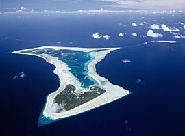
Aerial view of Pukapuka Atoll
|
|
| Geography | |
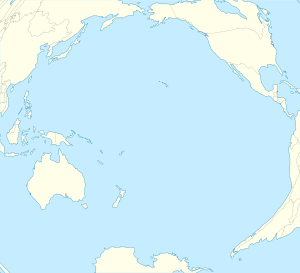
| Location | Central-Southern Pacific Ocean |
| Coordinates | 10°53′00″S 165°51′00″W / 10.88333°S 165.85000°W |
| Archipelago | Cook Islands |
| Area | 5 km2 (1.9 sq mi) |
| Administration | |
| Demographics | |
| Population | 425 (2016) |
| Ethnic groups | Polynesian |
Pukapuka, once called Danger Island, is a coral atoll in the northern part of the Cook Islands. It is located in the Pacific Ocean. Pukapuka is one of the most faraway islands in the Cook Islands. It sits about 1,140 kilometers (708 miles) northwest of Rarotonga. On this small island, people have kept their old culture and a special language for many centuries. The traditional name for the atoll is Te Ulu-o-Te-Watu, which means 'the head of the stone'. The northern islet, where most people live, is lovingly called Wale, meaning 'Home'.
Contents
Island Geography
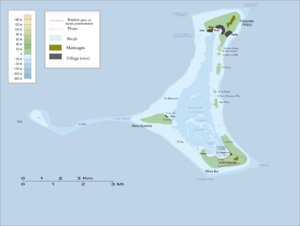
Pukapuka looks a bit like a three-bladed fan. It has three small islands on a reef that is roughly shaped like a triangle. The total land area is about 3 square kilometers (1.2 square miles).
- Motu Kō is the biggest island and is in the southeast.
- Motu Kotawa (also called Frigatebird Island) is in the southwest.
- The main island, Wale, is in the north.
Kō and Motu Kotawa are not lived on. They are used to grow food like taro and pulaka, and they have coconut trees. The Pukapuka Airport (NCPK) is on Kō.
The three villages are on the northernmost islet of the atoll, along a crescent-shaped bay:
- Yātō (West)
- Loto (Central)
- Ngake (East)
Loto (often called Roto on maps) is where the island's main office is. The old names for these villages are Takanumi, Kotipolo, and Te Lāngaikula. In daily life, islanders often call them Tiapani (Japan), Malike or Amelika (United States), and Ōlani (Holland). When the villages have sports games, they even use the names and flags of these countries!
The Tima Reef is underwater and is about 23 kilometers (14 miles) southeast of Pukapuka. Nassau (Cook Islands) is another island about 60 kilometers (37 miles) away. The people of Pukapuka own Nassau, and it is managed as part of Pukapuka.
Island History
People have lived on Pukapuka for about 1,000 years. This was after the sea level became stable. Old stories say that the island was found by Tamayei, a god from Tonga. The first people to settle there came from Tonga. Pukapuka was like a bridge between the western and eastern parts of Polynesia. This can be seen in their tools and their language, which is similar to Samoan with some Tokelauan words.
Pukapukan stories talk about many trips to places like Tuvalu, Tokelau, Niue, Tonga, Rarotonga, and Tahiti. Some of their stone tools were made from rock that came from Tutuila in Samoa. People from Tahiti also passed through Pukapuka on their way to islands in Samoa and Tonga.
The island's population was probably more than 1,000 people at one point. However, it has had to recover from very low numbers more than once. Old stories mention at least two times when there were conflicts among the people. There was also a huge tsunami or cyclone that flooded the atoll. Only two women and 15 men survived that disaster.
First European Visitors
Europeans first saw Pukapuka in 1595. A Spanish explorer named Álvaro de Mendaña saw it on a special day for Saint Bernard and named it San Bernardo.
In 1765, a British naval group led by Commodore John Byron saw the island again. He called it the "Islands of Danger" because of the reefs and big waves. It was too risky to land there. The name "Danger Island" is still on some maps today.
According to old stories, an unknown ship visited Pukapuka in the mid-1700s. The chief of the Yalongo family, Tāwaki, bravely took a pipe from the captain's mouth. Sadly, he was then shot.
About 30 years later, in 1796, a French adventurer named Pierre François Péron saw the island. He was working on an American ship called the Otter. He named the islands "Isles de la Loutre" (Isles of the Otter). Péron and a small group landed but were not allowed to look around the island. Later, they traded items like tools and mats for knives and European goods near the ship.
Péron thought they were the first to find the island because the people seemed very scared of them. The Pukapukans were afraid because of the incident about 30 years earlier when Chief Tāwaki was harmed during a ship visit.
Because Pukapuka was so far away, not many ships visited until 1857. That year, the London Missionary Society sent Christian teachers from Aitutaki and Rarotonga. Luka Manuae from Aitutaki wrote a long story about their first days there in December 1857. Some families wanted to hurt the newcomers because of an event that happened a month before. But Vakaawi, a chief, protected them. In the days that followed, the islanders accepted Luka's Christian message. This happened partly because two people who had died seemed to come back to life.
By 1862, most people on the island had become Christian. In 1863, some people who took islanders away by force (called "blackbirding" slave traders) took 145 men and women. Only two of them, Kolia and Pilato, ever returned. In 1864, a missionary ship called the John Williams was wrecked on the western side of the island. In 1868, a buccaneer named Bully Hayes took about 40 people for a work plan, but none of them came back home.
Pukapuka became a British protectorate in 1892. This meant Britain protected it. In 1901, it became part of the Cook Islands, controlled by New Zealand.
World War II and Beyond
Three U.S. Navy pilots from the USS Enterprise arrived on Pukapuka in February 1942. Harold Dixon, Gene Aldrich, and Tony Pastula had survived 34 days on a small raft in the ocean. They had no food or water when they started. Teleuka Iotua found them in a hut and gave them coconuts to drink. He then got more help. Soon after they arrived, a cyclone hit the island, causing a lot of damage. Their amazing story was told in a book called The Raft and later in a movie called Against the Sun.
| Historical population | ||
|---|---|---|
| Year | Pop. | ±% |
| 1906 | 435 | — |
| 1916 | 474 | +9.0% |
| 1926 | 526 | +11.0% |
| 1936 | 651 | +23.8% |
| 1945 | 662 | +1.7% |
| 1951 | 559 | −15.6% |
| 1961 | 718 | +28.4% |
| 1966 | 684 | −4.7% |
| 1971 | 732 | +7.0% |
| 1976 | 785 | +7.2% |
| 1981 | 797 | +1.5% |
| 1986 | 761 | −4.5% |
| 1996 | 779 | +2.4% |
| 2001 | 664 | −14.8% |
| 2006 | 507 | −23.6% |
| 2011 | 451 | −11.0% |
| 2016 | 444 | −1.6% |
| Source: | ||
In February 2005, Pukapuka was hit by Cyclone Percy. This was a very strong cyclone that ruined the taro gardens, knocked down thousands of trees, and damaged three-quarters of the houses.
Treaty with the United States
From 1856 to 1980, the United States said it owned Pukapuka. This was under a law called the Guano Islands Act. On June 11, 1980, the United States signed a treaty with the Cook Islands. This treaty recognized that Pukapuka belonged to the Cook Islands.
Island Economy
Even though Pukapuka has a good airport runway, flights from Rarotonga are not very often. A five-hour flight from Rarotonga, run by Air Rarotonga, now happens only about every six weeks. This is usually when the government charters a plane. The island is closer to Samoa than to the rest of the Cook Islands. Because of this, many Pukapukans visiting from New Zealand and Australia now prefer to travel through Samoa.
Pukapukan Culture
Pukapuka has its own language and traditions. These are different from those in the rest of the Cook Islands.
It is said that everyone living on the island today came from 17 men, two women, and some children. They were the only ones who survived a terrible storm and tsunami in the 17th century. A newer guess, based on old stories, suggests this disaster happened around 1590. After people were taken away by force in the 1800s, the island's population dropped to 340 people by 1870.
In 2001, the island had 664 people. But since 2005, the population has gone down to less than 500.
The American writer Robert Dean Frisbie moved to Pukapuka in 1924. He married a local woman and raised his family there. He wrote several books about his life on Pukapuka and nearby islands. He once said he was looking for a place far from "the slightest sound from the noisy world of civilization." Frisbie’s daughter Johnny and her trip back to Pukapuka are shown in the 2021 movie The Island in Me.
See also
 In Spanish: Pukapuka (islas Cook) para niños
- Pukapukan language
- List of Guano Island claims
- List of reduplicated place names
 | Frances Mary Albrier |
 | Whitney Young |
 | Muhammad Ali |


