
Hockenhull Platts facts for kids
Quick facts for kids Hockenhull Platts Nature Reserve |
|
|---|---|

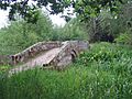
The westernmost bridge
|
|
| Lua error in Module:Location_map at line 420: attempt to index field 'wikibase' (a nil value). | |
| Type | Nature reserve |
| Location | near Tarvin, Cheshire |
| OS grid | SJ476657 |
| Area | 5 hectares (12 acres) |
| Elevation | 15 metres (49 ft) |
| Operated by | Cheshire Wildlife Trust |
| Open | at all times |

Hockenhull Platts is a special place in Cheshire, England. It has three old bridges near the village of Tarvin. People sometimes call them the "Packhorse Bridges." These bridges are so important that they are protected as Grade II listed buildings. They cross the River Gowy on a path called Platts Lane. Part of this area, including one of the bridges, is a nature reserve. The Cheshire Wildlife Trust looks after this reserve.
Contents
What's in a Name? The Meaning of Hockenhull Platts
The name "Hockenhull Platts" might come from a mix of English and Welsh words. The word Platt is an old English word for "bridge." It is linked to the word "plank." Hock might come from a Welsh word meaning "to sell things." Hen is Welsh for "old," and heol means a paved road. So, "Hockenhull Platts" could mean "the bridges on the old peddlers' way." A peddler was someone who traveled around selling goods.
A Journey Through Time: The History of the Bridges
Platts Lane was once part of an important road. This road went from London all the way to Holyhead in Wales during the Middle Ages. In 1353, a famous person named Edward, the Black Prince, crossed these bridges. He ordered that money be spent to fix them. By the 1600s, the road surface was very bad. Posts were put up to stop carts from using it. Only people walking or riding horses could pass. Goods were carried by groups of packhorses. A driver, called a jagger, walked in front of them. Famous travelers like Celia Fiennes in 1698 and Thomas Pennant in 1780 also crossed these bridges.
The bridges we see today were likely built in the late 1700s. In 1824, there was a plan to change a main road. This new road would have gone through Platts Lane, which would have meant destroying the bridges. However, the land belonged to the Marquess of Westminster. He refused to let the road be moved, saving the bridges.
Hockenhull Platts Today: Bridges and Nature
Hockenhull Platts has three humpback bridges. These are bridges with a high arch in the middle. They are connected by raised paths called causeways. The bridges are made from red sandstone blocks. Their sides are plain, with flat stones on top. These top stones are held together with iron ties. The path across the bridges is made of stone setts and cobbles.
The middle bridge crosses the River Gowy. Long ago, the whole area was very marshy. The three bridges and causeways were needed to cross the wet land. In the 1900s, the water level of the River Gowy was lowered. This was done to prevent flooding at the Stanlow Refinery nearby. Because of this, the marshes dried up. The middle bridge's base was also raised with concrete.
Today, a long-distance path called the Baker Way crosses these three bridges.
Hockenhull Platts Nature Reserve
The area west of the River Gowy is now a nature reserve. This includes the westernmost bridge. The Cheshire Wildlife Trust manages the reserve. They work with Grosvenor (Eaton) Estates. The nature reserve covers about 11 acres (4.5 ha). You need a special permit to enter. The reserve has a trail called the Mill Trail. It includes different natural areas like a poplar tree plantation and wet meadows. These meadows are full of different plant species. The poplar plantation is quite open, and its wet ground has allowed a special type of common reed to grow there.
The reserve is also a great place for birds. Over 64 different kinds of birds have been seen here. This includes three types of warblers that visit in summer, like the sedge warbler. Otters have also been seen along the banks of the River Gowy.
Hidden History: Archaeological Finds
Just south of the central bridge, there is an earthwork. This is a shape made in the ground by people long ago. You can only see it clearly when the sun is low in the sky. It looks like a low, rectangular mound with a ditch around it. It probably dates from the time after the Middle Ages. The rest of the area has old drainage channels.
Before 1940, some prehistoric flints were found in the Hockenhull Platts area. Flints are types of stone. These were worked by early humans to make tools. One was white and the other was grey.
Images for kids
-
The westernmost bridge
-

The easternmost bridge with the central bridge visible beyond
