Hockingport, Ohio facts for kids
Quick facts for kids
Hockingport, Ohio
|
|
|---|---|

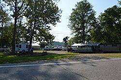
Looking eastward from State Route 124 into a campground in Hockingport, Ohio
|
|

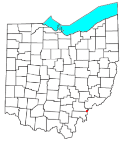
Location of Hockingport, Ohio
|
|
| Country | United States |
| State | Ohio |
| County | Athens |
| Elevation | 633 ft (193 m) |
| Population
(2020)
|
|
| • Total | 205 |
| Time zone | UTC-5 (Eastern (EST)) |
| • Summer (DST) | UTC-4 (EDT) |
| ZIP code |
45739
|
| Area code(s) | 740 |
| GNIS feature ID | 2628901 |
Hockingport is a small community in southeastern Athens County, Ohio, United States. It is known as a census-designated place, which means it's a specific area identified for population counting. In 2020, about 205 people lived there.
This community has its own post office with the ZIP code 45739. You can find Hockingport where two main roads, State Route 124 and State Route 144, meet. It sits right on the Ohio River, located between the towns of Little Hocking and Reedsville.
History of Hockingport
Hockingport has an interesting past, especially from before the American Revolution.
Fort Gower and Early History
In October 1774, soldiers from Virginia built a military camp and fort here. It was called Fort Gower. The fort was located where the Hocking River meets the Ohio River. This fort was a main base for the soldiers during a conflict known as Dunmore's War.
The soldiers at Fort Gower also wrote an important statement in November 1774. It was called the Fort Gower Resolves. Many brave leaders who later became famous in the American Revolution were at this fort. Some of them included George Rogers Clark and Daniel Morgan. After Dunmore's War, the fort was no longer used. Today, experts believe the original site of Fort Gower is now underwater, just off the point where the rivers meet.
A Shipping Point Community
A post office opened in Hockingport in 1838. The community got its name because it was an important place for shipping goods on the Hocking River. "Port" in its name refers to its role as a river shipping location.
See also
 In Spanish: Hockingport (Ohio) para niños

