Hogback Mountain (Klamath County, Oregon) facts for kids
Quick facts for kids Hogback Mountain |
|
|---|---|

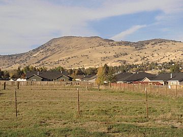
Hogback Mountain viewed from Klamath Falls, OR
|
|
| Highest point | |
| Elevation | 6,205 ft (1,891 m) NAVD 88 |
| Prominence | 1,280 ft (390 m) |
| Geography | |
| Location | Klamath County, Oregon, U.S. |
| Parent range | Cascades |
| Topo map | USGS Altamont |
| Climbing | |
| Easiest route | Hike, mountain bike |
Hogback Mountain (sometimes called Hogsback Mountain) is a large hill located northeast of Klamath Falls, Oregon, in the United States. It got its name because, when you look at it from Klamath Falls, the hill's shape reminds people of a pig's back or shoulders.
Visiting Hogback Mountain
Most of Hogback Mountain is owned by private individuals. However, many parts are open for people who enjoy hiking. It's a great place to explore nature and get some exercise.
Rules for Visitors
To keep the mountain safe and enjoyable for everyone, there are a few important rules:
- Please do not damage any fences. These fences help keep livestock (like cows) safe in their pastures.
- Using all-terrain vehicles (ATVs) is not allowed. This helps protect the land and the animals living there.
- Hunting and using firearms are not permitted without special written permission from the landowners.
Safety and Access
For your safety, there are times when public access to Hogback Mountain is limited. This usually happens during certain hunting seasons. During these times, landowners and their guests might be hunting on the mountain. Always check for any signs or notices about access restrictions before you visit.
 | Selma Burke |
 | Pauline Powell Burns |
 | Frederick J. Brown |
 | Robert Blackburn |


