Holland (CDP), Massachusetts facts for kids
Quick facts for kids
Holland, Massachusetts
|
|
|---|---|

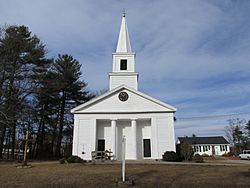
Congregational Church
|
|

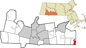
Location in Hampden County in Massachusetts
|
|
| Country | United States |
| State | Massachusetts |
| County | Hampden |
| Town | Holland |
| Area | |
| • Total | 3.27 sq mi (8.46 km2) |
| • Land | 2.65 sq mi (6.87 km2) |
| • Water | 0.61 sq mi (1.59 km2) |
| Elevation | 696 ft (212 m) |
| Population
(2020)
|
|
| • Total | 1,551 |
| • Density | 584.40/sq mi (225.67/km2) |
| Time zone | UTC-5 (Eastern (EST)) |
| • Summer (DST) | UTC-4 (EDT) |
| ZIP code |
01521
|
| Area code(s) | 413 |
| FIPS code | 25-30630 |
| GNIS feature ID | 0609813 |
Holland is a small community in Massachusetts, United States. It's known as a census-designated place (CDP), which means it's a special area defined by the government for counting people. Holland is located in Hampden County and is part of the larger Springfield area.
In 2010, about 1,464 people lived in the Holland CDP. The entire town of Holland had a population of 2,481 people at that time.
Contents
Geography of Holland
The Holland CDP is located in the eastern part of the town of Holland. Its exact coordinates are 42°2′40″N 72°9′13″W / 42.04444°N 72.15361°W.
What Makes Up the CDP?
The CDP includes the main town center, which is along Sturbridge Road. It also covers homes near Hamilton Reservoir. This is a lake in the southeastern part of the town.
Water Features and Nearby Towns
The water from Hamilton Reservoir flows north into the Quinebaug River. Another town called Sturbridge is about 6 miles (10 km) northeast of Holland. You can reach it by following Sturbridge Road.
Land and Water Area
The Holland CDP covers a total area of about 8.5 square kilometers (3.3 square miles). Most of this area, about 6.9 square kilometers (2.7 square miles), is land. The rest, about 1.6 square kilometers (0.6 square miles), is water, making up almost 19% of the total area.
Population and People
| Historical population | |||
|---|---|---|---|
| Census | Pop. | %± | |
| 2020 | 1,551 | — | |
| U.S. Decennial Census | |||
As of the census in 2000, there were 1,444 people living in the Holland CDP. These people lived in 561 households, and 399 of these were families.
How Many People Live Here?
The population density was about 206 people per square kilometer (533 people per square mile). There were 962 housing units, which means places where people live. On average, there were about 137 housing units per square kilometer (355 per square mile).
Age Groups in Holland
The population in the CDP was spread out across different age groups:
- About 26.8% of the people were under 18 years old.
- About 5.5% were between 18 and 24 years old.
- About 34.1% were between 25 and 44 years old.
- About 24.3% were between 45 and 64 years old.
- About 9.3% were 65 years old or older.
The average age of people in the CDP was 37 years. For every 100 females, there were about 104 males.
See also
 In Spanish: Holland (condado de Hampden) para niños

