Holtun facts for kids
 |
|
| Location | Melchor de Mencos |
|---|---|
| Region | Petén Department, Guatemala |
| Coordinates | 16°58′25″N 89°25′32″W / 16.97361°N 89.42556°W |
| History | |
| Founded | Middle Preclassic Period |
| Abandoned | Late Classic Period |
| Periods | Classic Period |
| Cultures | Maya civilization |
| Site notes | |
| Archaeologists | IDAEH |
| Architecture | |
| Architectural styles | Classic Maya |
| Responsible body: IDAEH | |
Holtun, originally called La Máquina, is an ancient Maya city. It is located in the Petén Department of northern Guatemala. You can find it on the road that goes from Flores to Melchor de Mencos.
This city was lived in for a very long time. People lived there from the Middle Preclassic period (around 1000 BC) all the way to the Late Classic period (around AD 900). Holtun became officially known in 1994. This happened after people in the area reported that valuable items were being stolen from the site. These thefts showed that there were large masks carved into the side of one of the main buildings. Holtun is the southernmost Maya city in the lowlands known to have these kinds of masks.
The site is special because it has two unique types of building groups. One is a triadic acropolis, which is a large pyramid with three smaller buildings on top. The other is an E-Group, a special arrangement of buildings used to track the sun's movements. These types of buildings show how advanced the Maya people were during the Preclassic period. Also, the ground in this area is made of karstic rock, which is like limestone. This allowed the Maya to create many underground storage pits called chultuns. You can find these pits in almost all the building groups at Holtun.
Contents
Location and Name of Holtun
The site was first called La Maquina, named after the closest village. Later, Agustín Estrada Monroy, who was in charge of cultural heritage, renamed it Holtun. The new name comes from the local Itza Maya language. It means "stone head," likely referring to the carved masks found there.
The land around Holtun has been cleared of trees. It is now used to grow crops like maize (corn), beans, and plantains. The land is owned by both the local government and private people.
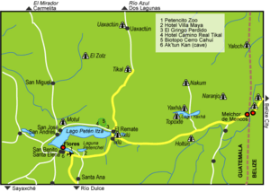
Holtun is surrounded by other important ancient Maya cities. Tikal is about 35 kilometers (22 miles) to the northwest. Yaxha is about 12.3 kilometers (7.6 miles) to the north. Naranjo is about 25 kilometers (16 miles) north of Holtun.
The ruins of Holtun are located about 1.3 kilometers (0.8 miles) south of La Maquina village. The site is on a hilly area with limestone ridges. It sits on a hilltop about 300 meters (980 feet) above sea level. Three streams that flow only during certain seasons border the site on the south, east, and west. There are no large rivers very close to Holtun because of the hilly land.
History of the Ancient City
People lived at Holtun for a very long time. The city was occupied from the Middle Preclassic period (around 1000 BC) until the Late Classic period (around AD 900).
Archaeologists have found evidence that the Holtun area was first settled during the Early Preclassic period. This evidence comes from pottery pieces found in old trenches. During the Late Preclassic period, people built the Triadic Acropolis. In the Early Classic period, important people lived in special residential groups. Later, in the Late Classic period, buildings were changed for people to live in. There is very little evidence that people lived there during the Terminal Classic period (after AD 900).
Modern Discovery and Research
Holtun was officially discovered in February 1994. This happened when the Guatemalan Instituto de Antropología e Historia (IDAEH), which is the "Institute of Anthropology and History," was told about thefts at a new site. This site was located between Flores and Melchor de Mencos.
IDAEH investigators arrived at the site several months after the thefts had begun. By then, the main buildings had already been damaged. IDAEH carefully studied the site in June and July 1994. New archaeological research began in 2010. This work was led by Brigitte Kovacevich and Michael Callaghan from Southern Methodist University.
Archaeological Projects
The first official look at the site was in 1994 by Erick Ponciano. He created the first map of Holtun. In 1998 and 2001, more studies were done to save information from the damaged areas. This work helped document the site and its features, especially the masks on the buildings and the underground chultuns. These studies were done by the Yaxhá project, part of the National Institute of Anthropology and History of Guatemala, and led by Vilma Fialko.
In 2010, the Holtun Archaeological Project began its first field season. This project was supported by Southern Methodist University. During this time, the team explored and surveyed the site thoroughly, creating a new map. In 2011, they dug small test pits in the plazas. This helped them learn about the different types of pottery used over time. They also studied how the buildings changed to understand settlement patterns. In 2012, the team analyzed the materials they had collected. This included pottery, Obsidian (volcanic glass), and carbon samples for Radiocarbon dating (a way to find out how old something is). In 2014, they dug more test pits and added new areas to the map. They also took soil samples to study the chemical makeup of the floors using X-ray fluorescence.
Mapping the Site
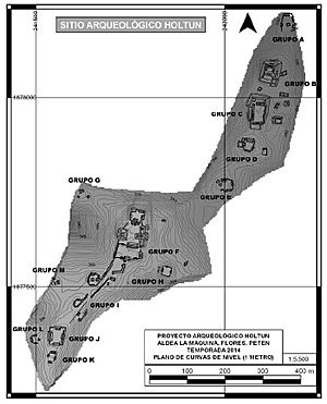
Holtun has been mapped three times since 1994. The first map, made in 1994, showed 86 structures. These were organized into four main groups, called A, B, C, and D. The second map was made by the "Proyecto de Sitios Arqueológicos de Petén" (PROSIAPETEN). This map updated the first one and identified 115 structures in 14 larger groups.
The third and most recent map was created by the Holtun Archaeological Project, which started its research in 2010. This project has been supported by the Department of Anthropology at Southern Methodist University. The map has been updated over three different mapping seasons. It now shows more than 200 structures and over 27 chultuns.
What Holtun Looks Like
The site has about 115 structures. They are mostly spread out from north to south, following the natural shape of the land. There are six main groups of buildings. Four of these groups are on hilltops. The other two are in lower, dry areas that do not flood. Archaeologists have named the four main groups A, B, C, and D.
Group A: The Largest Area
This is the biggest group of buildings at Holtun. It is located at the very northern end of the site.
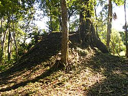
Structure A-1 is a huge base platform. It measures about 50 by 70 meters (160 by 230 feet) and is 8 meters (26 feet) tall. On top of this platform is a smaller platform (A-2) and two other buildings (A-3 and A-7). These two buildings are on either side of a courtyard. The smaller upper platform holds three more buildings (A-4, A-5, and A-6) around another courtyard. This whole complex faces south. It is believed to be a Late Preclassic triadic pyramid structure.
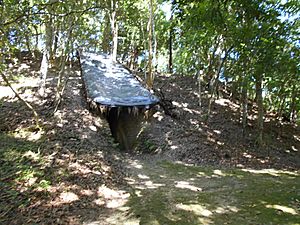
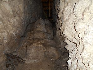
Structure A-2 is a smaller platform on top of Structure A-1. It measures about 30 by 20 meters (98 by 66 feet) and is 8.5 meters (28 feet) tall. It has two large masks on its south side. These masks are made of stone and stucco (a type of plaster). They were found when thieves dug a huge trench into the building, which is how the site got its name. One mask looks like a person, and the other looks like an animal. Both have features of a jaguar.
Structures A-4, A-5, and A-6 are smaller buildings on top of Structure A-2. Each is about 2.4 meters (7.9 feet) tall.
Structure A-3 and Structure A-7 are mounds on the south side of the main platform. They stand on either side of the entrance to the platform.
Structure A-8 is a large pyramid about 34 meters (112 feet) south of Structure A-1. It measures about 55 by 95 meters (180 by 312 feet). It supports many smaller buildings (A-9 to A-20) that surround a courtyard. These smaller buildings are about 8.5 meters (28 feet) wide and 2.7 meters (8.9 feet) tall. Structure A-9 is the largest building on Structure A-8.
Structures A-21 to A-24 are four low mounds, each about 1.2 meters (3.9 feet) tall. They are located east of Structure A-8.
Group B: Smaller Clusters
Group B is about 60 meters (200 feet) south of Group A. It has two small groups of buildings, each around its own plaza. This group also has several chultunob, which are underground storage rooms.
Structures B-1, B-2, and B-3 form a courtyard. These buildings are about 5 by 10 meters (16 by 33 feet).
Structure B-4 is a small platform east of structures B-1 to B-3.
The south plaza of Group B is about 480 square meters (5,200 square feet). It is surrounded by several buildings. Structure B-5 is on the north side of this plaza. It measures about 7 by 12 meters (23 by 39 feet) and is 2.6 meters (8.5 feet) tall. Structures B-6 and B-7 are on the east side. Structure B-8 is a long building on the south side. Structures B-9 and B-10 are on the west side.
Group C: Clustered Buildings
This group is about 160 meters (520 feet) southeast of Group B. It has 29 buildings, mostly on a flattened hilltop.
Structure C-1 is a small mound on the north side of the group, near a chultun.
Structures C-2 to C-5 form a compact group of buildings. They measure about 35 by 24 meters (115 by 79 feet) and are 6.2 meters (20 feet) tall. They look like a T-shape from above.
Structure C-6 is on the east side of this complex. It measures about 22 by 6 meters (72 by 20 feet).
Structure C-7 is the largest building in Group C. It is about 20 meters (66 feet) square and 6.3 meters (21 feet) tall. It is on the south side of the complex.
Structure C-8 is on the east side. It measures about 6 by 12 meters (20 by 39 feet) and is 2.6 meters (8.5 feet) tall.
Structures C-15 to C-21 are long buildings, up to 47 meters (154 feet) long, south of the group. They seem to be walls that enclose a path leading to another group of buildings.
Structures C-22 to C-29 form a clear cluster around a central courtyard. This cluster is next to a possible raised road (causeway) that goes south from Group C to Group D. Most of these mounds are small. Structures C-22 and C-25 are larger, about 6 meters (20 feet) across and 3.6 meters (12 feet) tall. The whole complex is on a flattened platform. The central courtyard is about 140 square meters (1,500 square feet).
Group D: Connected by a Causeway
Group D is south of Group C. It is connected to Group C by a causeway, which is a raised road. This causeway is 10 to 12 meters (33 to 39 feet) wide and 200 meters (660 feet) long.
Structures D-1, D-2, and D-3 form a small group next to the causeway. Structure D-2 is on the south side. It measures about 5 by 6 meters (16 by 20 feet) and is 3.2 meters (10 feet) tall. These three buildings surround a small courtyard, except on the east side.
Structures D-4 to D-10 are arranged around a central plaza. This plaza is about 735 square meters (7,910 square feet) and is mostly supported by Structure D-11.
Structure D-4 is on the north side of the plaza. It measures about 10 by 12 meters (33 by 39 feet) and is 4.4 meters (14 feet) tall.
Structure D-6 is a large building on the west side of the plaza. It measures about 10 by 20 meters (33 by 66 feet) and is 3.8 meters (12 feet) tall.
Structure D-9 is also on the west side of the plaza and is the largest building in Group D. It measures about 23 by 13 meters (75 by 43 feet) and is 4.6 meters (15 feet) tall.
Structure D-10 is on the west side of the plaza. It measures about 10 by 6 meters (33 by 20 feet) and is 1.7 meters (5.6 feet) tall.
Structure D-11 is an artificial platform. It supports the southernmost group of buildings and is reached by the causeway.
Structures D-12, D-13, and D-14 form another small plaza group. The plaza is about 120 square meters (1,300 square feet) and is open on the south side.
Amazing Sculptures
The most famous features of Holtun are the masks found on Structure A-2. They seem to have been on either side of the main staircase.
The first mask was found 4 meters (13 feet) below a sloped stone wall (talud). It was only partly uncovered, and traces of red paint were found on its plaster. This part of the mask is 90 centimeters (35 inches) tall and 12 centimeters (4.7 inches) thick.
The second set of masks was found 8 meters (26 feet) inside the main tunnel dug by thieves. There are three masks made from limestone blocks and covered with a 30-centimeter (12-inch) thick layer of stucco. These masks are angled at 45 degrees. The lowest one is an animal mask with cat-like features. It measures 87 by 86 centimeters (34 by 34 inches). Right above it is another mask measuring 130 by 86 centimeters (51 by 34 inches). This one looks like a person and is in good condition. It has round eyes, a noticeable upper lip, a flat nose, and a mouth that turns down. The third mask was destroyed by the thieves. Experts think it was about 1.6 meters (5.2 feet) tall, based on the remaining stucco pieces.
The last set of masks was found 16 meters (52 feet) into the thieves' tunnel. These two masks are the best preserved at the site. The lower mask is 50 by 48 centimeters (20 by 19 inches). It was made from limestone blocks covered in a 60-centimeter (24-inch) thick layer of stucco. This is an animal mask that still has traces of red, cream, and black paint. The other mask is right above it and is covered in a 42-centimeter (17-inch) layer of stucco. This mask looks like a person, with only part of its right cheek showing. It also has traces of red, cream, and black paint. It even has orange spots around the cheek, similar to a jaguar's fur. Both of these masks are angled at 45 degrees.
See also
 In Spanish: Holtún para niños
 | Selma Burke |
 | Pauline Powell Burns |
 | Frederick J. Brown |
 | Robert Blackburn |


