Yaxha facts for kids
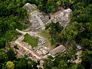
Aerial view of the North Acropolis
|
|
| Location | Flores |
|---|---|
| Region | Petén Department, Guatemala |
| Coordinates | 17°4′39″N 89°24′9″W / 17.07750°N 89.40250°W |
| History | |
| Founded | Middle Preclassic |
| Abandoned | Terminal Classic |
| Periods | Preclassic and Classic Periods |
| Cultures | Maya |
| Site notes | |
| Excavation dates | 1970s onwards |
| Archaeologists | Bernard Hermes Proyecto Nacional Tikal |
| Architecture | |
| Architectural styles | Preclassic and Classic Maya |
| Responsible body: IDAEH | |
Yaxha (pronounced Yah-shaa) was an important ancient city of the Maya people in what is now Guatemala. It was a big center for ceremonies and a bustling city long before Europeans arrived. Yaxha was the third biggest city in its area. It was most powerful during the Early Classic period, from about 250 to 600 AD.
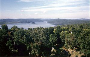
The city was built on a ridge, which is a long, narrow hill, overlooking Lake Yaxha. The name "Yaxha" comes from the Maya language and means "blue-green water." This is special because it's one of the few ancient city names that is still used today! The kingdom of Yaxha was quite large, covering about 237 square kilometers (92 square miles). At its busiest, during the Late Classic period, it had around 42,000 people living there.
Yaxha was settled a very long time ago, starting around 1000 to 350 BC. It grew into the largest city in the eastern Petén lakes region during the Late Preclassic period (about 350 BC to 250 AD). Then, it became an enormous city in the Early Classic period (about 250 to 600 AD). During this time, Yaxha was strongly influenced by Teotihuacan, a huge city far away in Mexico. Later, in the Late Classic period (about 600 to 900 AD), a nearby city called Naranjo became more powerful. However, Yaxha was never completely taken over. The city continued to thrive into the Terminal Classic period (about 800 to 900 AD) but was eventually abandoned by the time the Postclassic period began (around 900 to 1525 AD).
The ruins of Yaxha were first reported by an explorer named Teoberto Maler in 1904. Maps of the site were made in the 1930s and again in the 1970s. Work to protect and restore the ruins began in the late 1980s. Today, you can see the remains of more than 500 buildings. Many of the main areas are connected by ancient roads called sacbeob. About 40 stone monuments, called stelae, have been found at Yaxha. About half of these have carvings on them.
Contents
What Does Yaxha Mean?
The name Yaxha comes from the Maya word yaxa', which means "blue-green water." It's amazing that the city's original name from the Classic period, when it was a busy place, is still known today. A scholar named David Stuart was the first to suggest that the special symbol (called an emblem glyph) for the site should be read as Yax-ha. This shows that the name of the city and the lake are very old.
Where Is Yaxha Located?
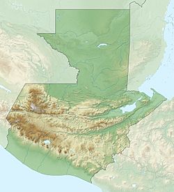
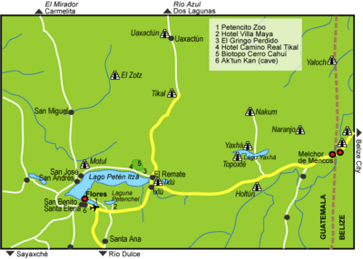
Yaxha is in the Petén region of northern Guatemala. It's about 30 kilometers (19 miles) southeast of another famous Maya city, Tikal. Yaxha sits on the north shore of Lake Yaxha. The ruins stretch for about 3 kilometers (1.9 miles) along a hilltop next to the lake.
The ruins are part of the Cultural Triangle Yaxha-Nakum-Naranjo National Park. This park covers a huge area of 37,160 hectares (91,824 acres). It includes the remains of four ancient Maya cities: Yaxha, Topoxte, Nakum, and Naranjo. It also has 10 smaller sites and over 280 tiny settlements.
Who Ruled Yaxha?
We don't know many of Yaxha's rulers, but here is one known king:
| Name | Ruled Around |
|---|---|
| K'inich Lakamtuun | 799 AD |
History of Yaxha
Yaxha has a long and interesting history, with people living there for many centuries.
Early Beginnings
Yaxha was already an important place in the Late Preclassic period (about 350 BC to 250 AD). It was a large settlement even earlier, in the Middle Preclassic (about 1000 to 350 BC). Archaeologists believe the first people settled in the southern and western parts of the city. During the Late Preclassic, Yaxha became the biggest settlement in its lake basin. More people moved there, and a lot of building work happened.
Growing Power
The city became most powerful during the Early Classic period (about 250 to 600 AD). During this time, Yaxha grew enormously. Unfortunately, many of the monuments from this period are not well preserved. This makes it hard to understand everything about its most powerful time.
However, we know that the powerful city of Teotihuacán in Mexico had a strong influence on Yaxha. This influence can be seen in the art and architecture of the Early Classic period. Towards the end of the Early Classic, an earthquake caused damage to buildings, especially in the East Acropolis. This earthquake might have caused people to leave the East Acropolis for a while. During this period, Yaxha became an important stop on the trade routes that went through the Petén lakes region.
Later Years and Challenges
In the Late Classic period (about 600 to 900 AD), the city continued to develop. Many big construction projects took place, especially in the 8th century. The twin pyramid complex is a great example of these large projects. Yaxha became an important trading center southeast of the great city of Tikal.
During this time, Yaxha fought several wars against its neighbor, Naranjo. Naranjo had become more powerful than Yaxha, but it could never completely take over. In 710 AD, the king of Naranjo, K'ak' Tiliw Chan Chaak, attacked Yaxha. He captured its king and killed him.
Later, in the late 8th century, the king of Naranjo, K'ak' Ukalaw Chan Chaak, married a princess from Yaxha. This princess, Lady Shell Star, gave him an heir. But this didn't stop the fighting. In 799 AD, Itzamnaaj K'awiil of Naranjo went to war against Yaxha and its allies. He attacked Yaxha in July and September of that year, after defeating some of Yaxha's smaller allied towns. He managed to capture Yaxha's king, K'inich Lakamtuun.
The Final Years
Unlike some other Maya cities, Yaxha didn't collapse quickly in the Terminal Classic period (about 800 to 900 AD). Instead, there's evidence of new and widespread building activity. It seems the leaders of Yaxha tried hard to keep their political system going. They even removed some controls at the city's entrances. This was done to encourage visitors from nearby areas that were more affected by the Maya collapse.
After the Terminal Classic, in the Postclassic period (about 900 to 1525 AD), there's little evidence of people living in the city itself. Some items like pottery and food waste were found, suggesting that people from the islands in Lake Yaxha might have visited the abandoned city.
Modern Discoveries
Teoberto Maler was the first to report finding Yaxha's ruins in 1904. The Carnegie Institution for Science mapped the ruins in the 1930s and again in the early 1970s. During the 1970s, small test digs were also done. In 1987, a project called "Proyecto Nacional Tikal" surveyed the damage at Yaxha. In 1988, the first work began to make some of the buildings stable.
Archaeological digs have continued into the 21st century. The South Acropolis was excavated from 2005 to 2007. These recent excavations were part of a program to help develop the Petén region in a sustainable way.
Exploring Yaxha
Yaxha is the third largest ancient ruin in Guatemala, only smaller than Tikal and El Mirador. The city center had many plazas (open squares) and groups of buildings. Areas outside the center and the lake shore were connected by ancient roads called sacbeob.
The main groups of buildings include the Maler Group in the north, the South (or Main) Acropolis, the West Group, the Northeast Acropolis, and the East Acropolis. These are all connected by causeways. The city was also linked to Lake Yaxha by the Lake Causeway. Plaza A is a special area with two pyramids built side-by-side, known as a twin pyramid complex.
Archaeologists have found ten main routes in the city. Four of these are considered major causeways, and the others are smaller "vias" or paths. Yaxha was more densely populated than most other Maya cities, meaning more people lived closer together.
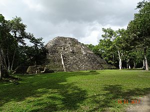
The site has over 500 structures. These include about 40 stelae (carved stone monuments), 13 altars, 9 temple pyramids, and 2 Mesoamerican ballcourts. From the top of Temple 216 (which has been restored), you can see both lakes on one side and the jungle and other stepped-pyramids on the other.
Yaxha has one of the very few twin pyramid complexes found outside of Tikal. This shows the political connections that influenced the city's building style when it was at its peak. However, it seems the complex at Yaxha was never fully finished.
Main Building Areas
Here are some of the important groups of buildings at Yaxha:
- Plaza A is a twin pyramid complex located north of the East Acropolis. It was built in the 8th century AD.
- Plaza B is on the west side of the East Acropolis.
- Plaza C is an E-Group, which is a special arrangement of buildings used to track the sun's movements and important astronomical events. It's southeast of the city center and connected by the Lincoln Causeway. Three Early Classic stelae were placed on its east side.
- Plaza D is in the city center, north of the South Acropolis.
- Plaza E is also in the city center, on the north side of the South Acropolis. It's connected by a stairway leading up from the plaza.
The East Acropolis is on the east side of the city center. It's the highest part of the city and is surrounded by Plazas A, B, and C. This area was first leveled from the natural limestone rock in the Middle Preclassic period. It started as a triadic pyramid complex (three pyramids around a central plaza) but was changed a lot in the Early Classic. In its final form, the East Acropolis was a closed area with twelve buildings covering about 8,100 square meters (87,188 square feet). The main buildings were Structure 216, a pyramid-temple, and Structure 218, a palace. The East Acropolis seems to have been left empty for a short time after an earthquake at the end of the Early Classic. But it was later reoccupied and developed during the Late Classic.
The Northeast Acropolis dates back to the Late Preclassic. It also includes a triadic pyramid that is part of an E-Group astronomical complex.
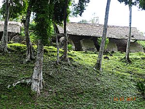
The South Acropolis, also called the Main Acropolis, was built on a high limestone hill. It has a long history, with construction starting in the Middle Preclassic and continuing into the Terminal Classic. This acropolis is a complex of six patio groups on an artificial platform. It also includes a Mesoamerican ballcourt (Ballcourt 1). The patios are separated by buildings with corbel-vaulted roofs, which were likely homes for important people.
Important Buildings
Here are some of the specific structures found at Yaxha:
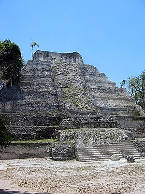
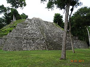
- Structure 216 is a large pyramid on the east side of Plaza A, part of the East Acropolis. The temple on top of the pyramid still stands. The whole structure is over 30 meters (100 feet) tall, making it the tallest building at Yaxha. An offering was found inside the temple, including seven carved stones called eccentrics (five made of obsidian and two of flint) and a piece of nacre (mother of pearl).
- Structure 217 is a palace-like building at the north end of Structure 218 in the East Acropolis. It had two rooms with vaulted ceilings.
- Structure 218 is another palace-like building in the East Acropolis. It was built and remodeled many times. The earliest version had a long room with a vaulted roof. Traces of red paint were found on its decorative edges. This building was affected by an earthquake, causing parts of it to sink. Later, it was combined with Structures 217 and 219 to create a new facade with nine doorways. Remains of painted murals were found inside, showing human figures near a palace and a ballcourt. A burial of an important person (Burial YX-08) was also found here.
- Structure 219 is a palace-like building at the south end of Structure 218 in the East Acropolis. It was rebuilt in a similar way to Structure 217.
- Structure 363 is a temple located between Patio 5 and Patio 6 of the South Acropolis. A stone monument was placed in front of this temple, which is unusual for a building within an acropolis.
Ancient Roads (Causeways)
The Maya built special raised roads called sacbeob (causeways) to connect different parts of their cities.
- The Lake Causeway (Calzada del Lago) runs north from the lake shore to the city center. It then continues as Via 5. The total length is about 400 meters (1,300 feet). This causeway was built to allow quick movement of goods and people between the city and the lake, and easy access to water. It likely started as a simple path in the Middle Preclassic. In the Late Classic, it was improved and extended. At one point, where it met Via 5, the path was made very narrow, only 2 meters (6.6 feet) wide. This was probably a guard post where people and goods entering the city were checked and taxed.
- The Blom Causeway (Calzada Blom) runs north from the city center to the Maler Group.
- The Galindo Causeway (Calzada Galindo) runs north-south between the East Acropolis and Plaza C.
- The Lincoln Causeway (Calzada Lincoln) runs southeast from the city center to Plaza C.
Carved Stone Monuments (Stelae)
About 40 Maya stelae have been found at Yaxha. Half of these are plain, without any carvings.
- Stela A is a plain stela placed on a platform at the southern (lake-side) end of the Lake Causeway.
- Stela 3 is one of three stelae on the east side of Plaza C. It's from the Early Classic period and is badly preserved.
- Stela 4 is the best-preserved stela on the east side of Plaza C. It shows a standing figure and has two hieroglyphs (ancient writings). One of these glyphs is the special symbol for Yaxha.
- Stela 5 is the southernmost stela on the east side of Plaza C. It's very worn but has been dated to 357 AD, making it the oldest dated monument at Yaxha.
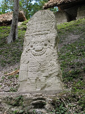
- Stela 11 is a well-preserved Early Classic monument on the east side of Plaza B. Its style is like that of Teotihuacan, showing a warrior with features of Tlaloc, a rain god from central Mexico. This stela is very similar to one found at Tikal and shows the influence of Teotihuacan in the Petén region during the Early Classic period.
- Stela 13 was a carved monument but is now broken into pieces. The writing on it includes a date from 793 AD, which is the latest date recorded at the city. It shows a king of Yaxha and describes a celebration of an equinox (when day and night are equal length).
- Stela 41 was placed at the base of the stairway of Temple 216 in the 8th century AD. All four sides are carved in an Early Classic style. The front shows two masks and a human-like figure. The hieroglyphic writings on the north and south sides are worn but might include Yaxha's emblem glyph.
Burials at Yaxha
- Burial YX-08 was found in front of the main entrance to Structure 218, a palace-like building. The remains were placed in a stone-lined pit called a cist. They likely belonged to an important person, a young adult male in his early twenties. His skull was shaped differently, and his front teeth had jade pieces set into them. Two carved jade pieces were found near his neck, possibly jewelry.
See also
 In Spanish: Yaxhá para niños
 | Percy Lavon Julian |
 | Katherine Johnson |
 | George Washington Carver |
 | Annie Easley |


