Hornopirén (volcano) facts for kids
Quick facts for kids Hornopirén |
|
|---|---|

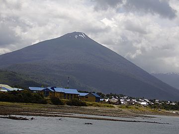
Hornopirén town and volcano.
|
|
| Highest point | |
| Elevation | 1,572 m (5,157 ft) |
| Geography | |
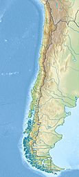
| Location | Chile |
| Parent range | Andes |
| Geology | |
| Mountain type | Stratovolcano |
| Volcanic arc/belt | South Volcanic Zone |
| Last eruption | 1835 (?) |
Hornopirén is a cool stratovolcano located in the Andes mountains of Chile. It's found in the Los Lagos Region, south of Yate Volcano. It's also east of a smaller volcanic cone called Apagado or Hualiaque.
A stratovolcano is a tall, cone-shaped volcano. It's built up over many years by layers of hardened lava, ash, and rocks from past eruptions.
The name Hornopirén is quite interesting! It comes from two words. Horno is a Spanish word meaning "oven." Pirén comes from the native Mapudungun language, meaning "snow." So, Hornopirén basically means "snow oven."
Scientists believe Hornopirén might have erupted way back in 1835. However, there aren't many details known about that event.
Where Hornopirén is Located
Hornopirén sits right on a major crack in the Earth's crust. This crack is called the Liquine-Ofqui Fault. A fault is like a long seam where different parts of the Earth's crust meet and move. This movement can cause earthquakes. It also allows hot melted rock, called magma, to rise to the surface, forming volcanoes like Hornopirén.
The volcano is part of a chain of volcanoes called the South Volcanic Zone. This zone stretches across Chile and is very active. It's a place where the Earth's tectonic plates are constantly interacting.
The town of Hornopirén is located about 10 kilometers (6 miles) south of the volcano. It sits on an inlet off the Gulf of Ancud.
See also
 In Spanish: Volcán Hornopirén para niños
- List of volcanoes in Chile
- Hornopirén National Park
 | Percy Lavon Julian |
 | Katherine Johnson |
 | George Washington Carver |
 | Annie Easley |


