
Horopito railway station facts for kids
Quick facts for kids
Horopito railway station
|
|||||||||||
|---|---|---|---|---|---|---|---|---|---|---|---|

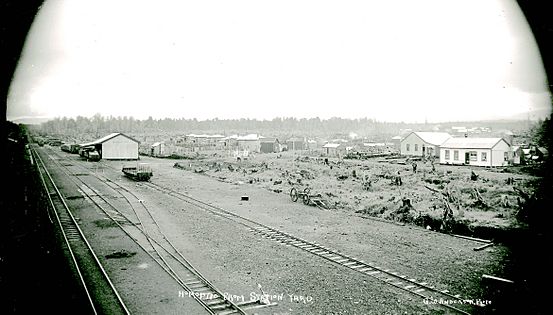
Horopito in 1957
|
|||||||||||
| Location | New Zealand | ||||||||||
| Coordinates | 39°20′37″S 175°22′41″E / 39.343657°S 175.378017°E | ||||||||||
| Elevation | 752 m (2,467 ft) | ||||||||||
| Line(s) | North Island Main Trunk | ||||||||||
| Distance | Wellington 327.5 km (203.5 mi) | ||||||||||
| History | |||||||||||
| Opened | in use from 31 May 1907 goods 12 August 1907 passengers 15 February 1909 |
||||||||||
| Closed | goods 19/9/1986 passengers before December 1975 |
||||||||||
| Electrified | June 1988 | ||||||||||
| Services | |||||||||||
|
|||||||||||
Horopito was a railway station located on the North Island Main Trunk line in New Zealand. It was found in the Ruapehu District and served the small village of Horopito. The station was just north of two very large railway bridges called viaducts.
Even though the station is no longer used, a special track called a passing loop is still there. This loop allows trains to pass each other on a single track.
Contents
Horopito Station: A Look Back
The railway line to Horopito was planned starting in 1894. The line opened for goods trains on 12 August 1907. Passengers could use the station from 15 February 1909.
A stationmaster, who managed the station, started working there by March 1908. In August 1908, Horopito was an important stop where train engines were sometimes changed. This helped make trains lighter for the tracks further north.
Building the Station
Work on the station building began in November 1908. By September 1909, a proper station building was ready. It had rooms for the stationmaster, a waiting area for passengers, and toilets. The station also had a long platform for people to get on and off trains.
Besides the main building, there was a shed for engines and a large shed for goods. There were also big water tanks for the steam trains, a loading area for cargo, and yards for cattle and sheep. Special signals were used to keep trains safe. Homes for railway workers were built starting in 1907.
The railway also had a "crossing loop" which was like an extra track. This loop was first long enough for 60 wagons and was made even longer in 1955 to hold 80 wagons. Electric lights were added to the station after 1924.
In 1971, the original station building was replaced with a simpler shelter. Finally, on 19 September 1986, Horopito station closed completely.
Gallery
-
Horopito station about 1910
-
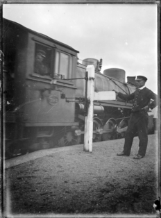
Changing the tablet at Horopito Railway Station in 1920.
-
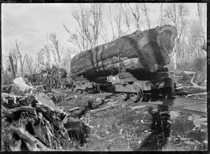
Horse-drawn timber wagon hauling a log to a mill at Horopito in 1921
-
Horopito in 1964


Timber Industry at Horopito
Just like other stations along this part of the railway line, Horopito was important for the timber industry. Many sawmills sent their wood from here.
Several timber companies operated nearby. Some mills had their own private railway tracks, called sidings, that connected directly to the station. Others used horse-drawn tramways to bring logs to the station. This shows how important the railway was for moving timber out of the area.
Amazing Viaducts
South of Horopito, the railway line crosses deep valleys. To do this, engineers built two huge bridges called viaducts. These were designed by Peter Seton Hay.
| Taonui viaduct | |
|---|---|

Taonui Viaduct in 1908
|
|
| Coordinates | 39°22′06″S 175°22′18″E / 39.36842°S 175.37166°E |
| Carries | Single track of the North Island Main Trunk |
| Crosses | Taonui Stream |
| Owner | Department of Conservation |
| Characteristics | |
| Total length | 400 feet (120 m) |
| Height | 111 feet (34 m) |
| History | |
| Engineering design by | PWD |
| Construction begin | 1906 |
| Opened | February 1908 |
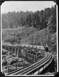
For many years, trains had to slow down a lot when crossing these old viaducts because of their sharp curves. So, in 1984, work began on a new, straighter section of railway line, which opened in 1987. This new section bypassed the old viaducts.
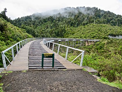
The old viaducts were then given to the Department of Conservation. From 2009, they became part of a walking and cycling path called the Mountains to Sea Trail.
The original viaducts were made of steel towers and girders. The steel parts were made in a workshop and then brought by train to the construction sites.
There are also other bridges nearby, including one over the Makotuku River just south of Horopito.
.jpg)
Taonui Viaduct
About 2.5 kilometers south of Horopito is the Taonui Viaduct. The newer viaduct is made of concrete and is 100 meters long and 20 meters high. It replaced the older, curved viaduct.
The original Taonui Viaduct opened in February 1908. It was 400 feet long and stood 111 feet above the stream. It had three steel towers supporting the middle part. When it was finished, passengers could walk across it while their coaches drove on the road below.
In 1918, a large fire damaged some parts of the viaduct. The viaduct was strengthened in 1934 and again in 1971 to keep it safe.
After the new railway line opened, the tracks and wooden deck were removed from the old viaduct. Today, plans to use this old viaduct for the cycle trail have been put on hold.
| Hapuawhenua viaduct | |
|---|---|

Northern Explorer on Hapuawhenua Viaduct in 2012
|
|
| Coordinates | 39°23′06″S 175°23′58″E / 39.38503°S 175.39955°E |
| Carries | Single track of the North Island Main Trunk |
| Crosses | Hapuawhenua Stream |
| Owner | KiwiRail |
| Characteristics | |
| Total length | 284 metres (932 ft) |
| Height | 45 metres (148 ft) |
| History | |
| Engineering design by | PWD |
| Construction begin | 1906 |
| Construction end | April 1908 |
Hapuawhenua Viaduct
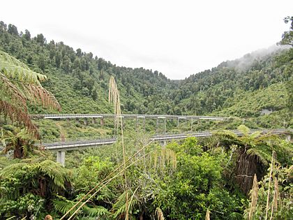
Another 2.5 kilometers south is the Hapuawhenua Viaduct. The newer one, built in 1987, is made of strong concrete. It is 414 meters long and stands up to 51 meters high.
The older Hapuawhenua Viaduct, completed in April 1908, is 284 meters long and 45 meters high. Building it required a lot of concrete, steel, and timber.
Work on the Hapuawhenua Viaduct started in 1906. By December 1907, the concrete supports were finished. The steel towers were completed in January 1908.
Like the Taonui Viaduct, the Hapuawhenua Viaduct was strengthened several times, in the 1920s, 1930s, and 1970s.
When the new railway line opened in 1987, the tracks were removed from the old Hapuawhenua Viaduct. A walkway was created using old railway sleepers and a new handrail.
In 1988, this viaduct became famous when AJ Hackett used it for what might have been the world's first commercial bungy jumping!
-
Hapuawhenua viaducts - 1908 at the back, 1987 in front
-
Hapuawhenua Viaduct about 1915
-
Hapuawhenua 1908 viaduct from the north


The Old Coach Road
A 15-kilometer section of the "Old Coach Road" between Horopito and Ohakune has been restored. This road was very important before the railway was fully built.
It mostly followed an older track used by horses, which was upgraded to a road for carts in 1895. Between 1904 and 1906, much of the road was paved with stones. This made it an all-weather road, perfect for carrying building materials for the railway.
From November 1906, the road was also used by coaches to carry passengers and goods between the parts of the railway that were already open. Even though it was sometimes muddy, a daily coach service ran. As more of the railway was finished, the coach trip became shorter.
After a main highway (State Highway 49) was built, the Old Coach Road was no longer used. However, like the viaducts, it is now a protected historic place. It was reopened in 2009 as part of a cycle trail, allowing people to explore this historic route.
