
Makotuku River facts for kids
Quick facts for kids Makotuku River |
|
|---|---|

|
|
| Native name | Mākōtuku |
| Country | New Zealand |
| Region | Manawatū-Whanganui |
| District | Ruapehu District |
| Settlements | Horopito, Raetihi |
| Physical characteristics | |
| Main source | Mount Ruapehu Sunset Ridge, Tūroa skifield 1,700 metres (5,600 ft) 39°18′7″S 175°31′44″E / 39.30194°S 175.52889°E |
| River mouth | Mangawhero River 455 metres (1,493 ft) 39°28′8″S 175°18′4″E / 39.46889°S 175.30111°E |
| Length | 40 km (25 mi) |
| Basin features | |
| Progression | Makotuku River → Mangawhero River → Whangaehu River |
| River system | Whangaehu River |
The Makotuku River is a cool river found in the western part of New Zealand's North Island. It starts high up on the slopes of Mount Ruapehu. The river then flows southwest, making its way through the landscape. It even passes by the town of Raetihi. Finally, the Makotuku River joins up with the Mangawhero River.
The name Mākōtuku comes from the Maori people. It means "white heron stream." This name was given by the New Zealand Ministry for Culture and Heritage. It tells us about the beautiful white herons that might have been seen near the river.
Where the River Flows
The Makotuku River begins its journey high up on Mount Ruapehu. This is a large volcano in New Zealand. The river's source is near Sunset Ridge, which is part of the Tūroa skifield. Imagine water melting from the mountain and starting a long trip!
River's Path
From its source, the river flows downhill. It travels about 40 kilometers (25 miles) in a southwest direction. As it moves, it collects water from smaller streams. This makes the river bigger and stronger.
Joining Other Rivers
The Makotuku River doesn't flow all the way to the sea by itself. Instead, it meets up with the Mangawhero River. This meeting point is called a confluence. The Mangawhero River then joins the Whangaehu River. So, the Makotuku River is an important part of a larger river system in the area.
Images for kids
-
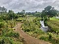
Makotuku River, walkway and Raetihi-Ohakune road bridge

