
Pokaka railway station facts for kids
Quick facts for kids
Pokaka railway station
|
|||||||||||
|---|---|---|---|---|---|---|---|---|---|---|---|

Pokaka circa 1924, still with Pokako name
|
|||||||||||
| Location | New Zealand | ||||||||||
| Coordinates | 39°17′33″S 175°23′25″E / 39.292489°S 175.390314°E | ||||||||||
| Elevation | 811 m (2,661 ft) | ||||||||||
| Line(s) | North Island Main Trunk | ||||||||||
| Distance | Wellington 332.77 km (206.77 mi) | ||||||||||
| History | |||||||||||
| Opened | in use from 20 March 1908 | ||||||||||
| Closed | 1 September 1971 | ||||||||||
| Electrified | June 1988 | ||||||||||
| Previous names | to 29 July 1922 was Pokako | ||||||||||
| Services | |||||||||||
|
|||||||||||
Pokaka was once a busy railway station in New Zealand. It was part of the important North Island Main Trunk line. This line connects the North Island from north to south. The station served a small village also called Pokaka. It was located south of the huge Makatote Viaduct. The station couldn't open until this viaduct was finished.
Contents
Station Name History
The station was first called Pokako. In 1922, its name was officially changed to Pokaka. This was done to fix what was thought to be a spelling mistake. However, both names were used for many years.
Pokaka Station's Story
Engineers started planning the railway route in this area in 1894. Building the Pokaka station began in November 1908. By March 1909, a station building was ready. It had a waiting shelter, a small office, and restrooms. There was also a platform for people to get on and off trains.
The station also had a shed for goods and a loading area. Farmers could use special yards for their cattle and sheep. Pokaka was an important stop where trains could pass each other. This passing track could hold many wagons. However, it was closed in 1986. Today, only one track runs through the old station site.
Pokaka station stopped handling goods in 1965. It closed completely for all train traffic in 1971.
Timber Industry and Trains
Like many stations on the North Island Main Trunk line, Pokaka helped transport timber. Several sawmills used the railway to send their wood. Some timber companies even had their own private railway tracks, called sidings. These sidings connected their mills directly to the main railway line.
One state-owned sawmill opened near Pokaka in 1922. It used special trains to carry timber. This wood was used to build houses for railway workers. The sawmill closed a few years later. The railway tracks from this mill were later sold to a timber company. They used a special type of steam engine called a Climax locomotive.

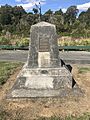
The Last Spike Monument
In early 1909, a special monument was built near Pokaka. It marks an important moment in New Zealand's history. On November 6, 1908, the Prime Minister, Sir Joseph Ward, held a "last spike" ceremony. This ceremony celebrated the completion of the North Island Main Trunk railway line. A silver-plated spike was used for the event.
The actual last spike was driven about 300 meters south of the monument. This happened when temporary tracks met at the Manganui-o-te-Ao viaduct. The monument is a concrete pillar about 6 feet (1.8 meters) tall. It has black letters on a white marble slab. It was moved slightly in 1973. Today, road signs on SH4 point to it, and there's a small parking area for visitors.
Amazing Railway Bridges
The railway line around Pokaka crosses deep valleys. To do this, engineers built huge bridges called viaducts. The Makatote Viaduct, Manganui o te Ao, and Mangaturuturu viaducts are all near Pokaka. They cross the Makatote, Manganui o te Ao, and Mangaturuturu valleys. These valleys drop steeply from Mount Ruapehu.
All these viaducts were designed by Peter Seton Hay. The concrete parts were built by the Public Works Department. The steel parts were built by a company from Christchurch.
Most of these viaducts were strengthened between 1925 and 1932. This was to make them strong enough for heavier trains.
Manganui o te Ao Viaduct
About a kilometer north of Pokaka is the Manganui o te Ao Viaduct. It is a straight bridge, 290 feet (88 meters) long. It stands 112 feet (34 meters) above the Manganui o te Ao River. The original bridge was replaced in 1967 with a new concrete viaduct.
| Mangaturuturu viaduct | |
|---|---|

Mangaturuturu viaduct in 1921
|
|
| Coordinates | 39°18′17″S 175°23′24″E / 39.30467°S 175.38987°E |
| Carries | Single track of the North Island Main Trunk |
| Crosses | Mangaturuturu River |
| Owner | KiwiRail |
| Characteristics | |
| Design | concrete pier, two 30 metres (98 ft) steel Warren trusses. |
| Material | Steel |
| Total length | 60 metres (200 ft) |
| Height | 18 metres (59 ft) |
| Number of spans | 2 |
| History | |
| Engineering design by | Andersons |
| Constructed by | PWD |
| Construction begin | 1907 |
| Construction end | June 1908 |
| Designated: | 20 February 2009 |
| Reference #: | 7779 |
Mangaturuturu Viaduct
Just over a kilometer south of Pokaka is the Mangaturuturu Viaduct. It is 61 meters (200 feet) long and up to 60 feet (18 meters) high. This viaduct is special because it is one of the few original bridges still standing from when the railway was first built. Because of its history, it was listed as a heritage site in 2009.
This bridge has been repaired many times over the years. In 1975, it survived a lahar, which is a powerful mudflow from a volcano. The lahar caused the river level to rise significantly, but the viaduct held strong.
Images for kids
-
The Last Spike Memorial is located 1.5 km north from the station

