
Horse Island (Michigan) facts for kids

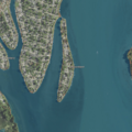
USGS aerial imagery of Horse Island
|
|

Horse Island
Location in Wayne County, Michigan

Horse Island
Location in Michigan

Horse Island
Location in the United States
|
|
| Geography | |
|---|---|
| Location | Michigan |
| Coordinates | 42°04′55″N 83°11′06″W / 42.08194°N 83.18500°W |
| Highest elevation | 571 ft (174 m) |
| Administration | |
|
United States
|
|
| State | |
| County | Wayne |
Horse Island is a small island located in the Detroit River in southeast Michigan, USA. It is part of Wayne County. The island's exact location is at coordinates 42°04′55″N 83°11′06″W / 42.08194°N 83.18500°W. In 1980, the United States Geological Survey (USGS) measured its elevation as about 571 feet (174 meters) above sea level. This island is known as a good spot for catching Walleye fish.
Contents
What is Horse Island?
Horse Island is a natural landform in the Detroit River. Rivers often have islands formed by the flow of water. These islands can be home to various plants and animals. Horse Island is one such example, providing a small habitat within the busy river system.
Where is Horse Island located?
Horse Island is found in the lower part of the Detroit River. This river connects Lake St. Clair to Lake Erie. The island is specifically within the boundaries of Wayne County, Michigan, which is a large county in southeastern Michigan. Its position in the river makes it a unique geographical feature.
How high is Horse Island?
The highest point on Horse Island is about 571 feet (174 meters) above sea level. This measurement was taken by the United States Geological Survey (USGS) in 1980. The USGS is a scientific agency that studies the Earth's landscape, natural resources, and natural hazards. Knowing the elevation helps us understand the island's physical characteristics.
What kind of fish can you find near Horse Island?
One of the notable things about Horse Island is that it's a good place for fishing. Anglers often visit the area to catch Walleye. Walleye are popular freshwater fish known for their tasty meat and their large, reflective eyes. They are common in the Great Lakes region, including the Detroit River.
Images for kids
-
USGS aerial imagery of Horse Island
