Horse Lakes 152B facts for kids
Quick facts for kids
Horse Lakes 152B
|
|
|---|---|
| Horse Lakes Indian Reserve No. 152B | |

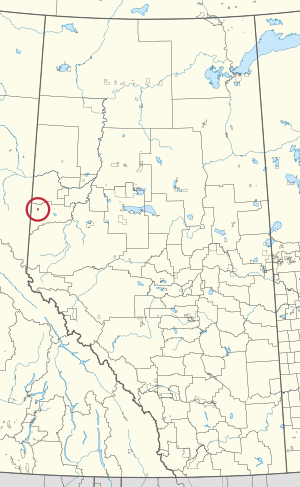
Location in Alberta
|
|
| First Nation | Horse Lake First Nation |
| Country | Canada |
| Province | Alberta |
| Municipal district | Grande Prairie |
| Area | |
| • Land | 14.33 km2 (5.53 sq mi) |
| Population
(2016)
|
|
| • Total | 469 |
| • Density | 32.7/km2 (85/sq mi) |
Horse Lakes 152B is a special area of land in Alberta, Canada. It is known as an Indian reserve, which means it is land set aside for the use and benefit of a First Nations group. This particular reserve belongs to the Horse Lake First Nation.
It is located about 60 kilometers (37 miles) northwest of a city called Grande Prairie. The land sits quite high up, at an elevation of about 774 meters (2,539 feet) above sea level.
Contents
Where is Horse Lakes 152B?
The area known as Horse Lake is actually found right on the Horse Lakes 152B reserve. This reserve is easy to reach, being only about 3.6 kilometers (2.2 miles) from Alberta Highway 43. You can get there by following Range Road 120 and Township Road 743.
A cool fact about this reserve is that it includes most of the lake that gives the area its name: Horse Lake!
Who Lives in Horse Lakes 152B?
We can learn about the people living in Horse Lakes 152B from official counts called censuses.
Population in 2016
According to the 2016 Canadian Census, there were 469 people living in Horse Lakes 152B.
Population Changes Over Time
In the 2011 Canadian Census, the population was 402 people. There were also 111 private homes where people lived. This number was a big jump from the 2006 Canadian Census, which recorded 335 people. This shows that the population in Horse Lakes 152B has been growing!
 | James B. Knighten |
 | Azellia White |
 | Willa Brown |

