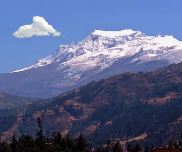
Hualcán facts for kids
Quick facts for kids Hualcán |
|
|---|---|
| Rajopaquinan | |
 |
|
| Highest point | |
| Elevation | 6,165 m (20,226 ft) |
| Prominence | 2,912 m (9,554 ft) |
| Parent peak | Huascaran |
| Geography | |
| Location | Ancash, Peru |
| Parent range | Andes, Cordillera Blanca |
| Climbing | |
| First ascent | August 1939 via South Ridge by Karl Schmid and Siegfried Rohrer (Germany) S. flank-1979. |
Hualcán, also known as Rajopaquinan, is a really tall mountain in Peru. It's part of the Andes mountain range, specifically in the Cordillera Blanca. This amazing peak stands about 6,165 meters (or 20,226 feet) high!
You can find Hualcán in the Ancash Region of Peru. It sits between two districts: Chacas and Carhuaz. The mountain is also located within the Huascarán National Park. This park is a special protected area for nature.
First Climbers
The first people to successfully climb Hualcán were Karl Schmid and Siegfried Rohrer. They were from Germany and made their climb in August 1939. This was a big achievement in mountain climbing!
How Tall is Hualcán?
Hualcán is officially measured at 6,165 meters (20,226 feet) tall. Scientists use special tools like digital elevation models to figure out mountain heights. These models use data from satellites. For example, data from SRTM and ASTER sensors both show Hualcán's height as 6,157 meters.
Hualcán is also considered a "Mountain Sub-System." This means it's a very important peak in its area. Its "parent peak" is Huascaran Sur, which is an even taller mountain nearby. Hualcán is about 13 kilometers away from Huascaran Sur.
See also
 In Spanish: Hualcán para niños
 | Toni Morrison |
 | Barack Obama |
 | Martin Luther King Jr. |
 | Ralph Bunche |


