Hubbardton Military Road facts for kids
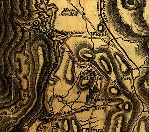
The Hubbardton Military Road was a special path built in the wilderness of western Vermont. It was created during the American Revolutionary War to help the American army. The road connected important forts on Lake Champlain with other roads and towns. This allowed soldiers and supplies to move quickly.
The road was about 35 miles long. It stretched from Mount Independence in Orwell, Vermont, to Rutland. In Rutland, it joined an older military road. This older road went from Crown Point to the Fort at Number 4 in New Hampshire.
The Hubbardton Military Road was built in the fall of 1776. It was ordered by Major General Horatio Gates, an American patriot. On July 6, 1777, many American soldiers used this road to retreat. They were stationed at Ticonderoga and Mount Independence. British and German troops chased them. This led to a battle called the Battle of Hubbardton on July 7.
After the war, the army stopped using this supply road. Over time, it turned into farmland and forests. Today, most of the road's path is known. Local historians still study old maps and the land to learn more about it.
Contents
What Was the Hubbardton Military Road?
The Hubbardton Military Road was more than just a path. It was a vital link for the American forces. It helped them move soldiers and supplies through the wild lands of Vermont. This was very important during the American Revolutionary War. The war was fought between the American colonies and Great Britain.
A Path Through the Wilderness
The road was cut through thick forests and rough terrain. It connected key military points. These points included forts on Lake Champlain. The lake was a major waterway for moving troops and goods. The road also linked to existing roads and small settlements. This network helped the American army stay connected.
Connecting Important Forts
The road started at Mount Independence. This was a strong American fort in what is now Orwell, Vermont. It then stretched about 35 miles eastward. Its end point was Rutland, which is now called Center Rutland. From there, it joined an older military road. This older road went all the way to the Connecticut River.
Building the Road
The construction of the Hubbardton Military Road was a big project. It happened quickly in the fall of 1776. The American army needed a way to move quickly. They also needed to get supplies to their soldiers.
Who Ordered the Road?
The road was built under the orders of Major General Horatio Gates. He was a key leader in the Continental Army. This was the main army of the American colonies. General Gates understood how important it was to have good supply routes. He knew they needed to move troops easily.
Why Was it Built?
The main reason for building the road was military strategy. It allowed the American army to reinforce their forts. It also helped them supply their soldiers. Without such a road, moving large amounts of food, weapons, and other necessities would have been very difficult. The road was a lifeline for the American forces.
The Road During the War
The Hubbardton Military Road played a crucial role in 1777. It was used during a major British attack. This attack was part of the Saratoga campaign.
The Retreat of 1777
On July 6, 1777, American forces faced a tough situation. Most of the American army in the northern region had to retreat. They were stationed at Ticonderoga and Mount Independence. They used the Hubbardton Military Road to escape. British and German troops were chasing them closely.
The Battle of Hubbardton
The retreat led to a fierce fight. This battle happened on the morning of July 7, 1777. It is known as the Battle of Hubbardton. It was a "rear guard action." This means a small group of soldiers fought to protect the main army as it retreated. The battle allowed most of the American army to get away safely.
After the War
Once the American Revolutionary War ended, the Hubbardton Military Road was no longer needed by the army. Its purpose changed.
From Road to Farmland
The military abandoned the road. Over time, nature began to reclaim it. Parts of the road became farmland. Other sections grew back into dense forests. Today, you might not even know it was once a busy military route.
Studying the Past
Even though it's no longer a road, its history is still important. Local historians are very interested in the Hubbardton Military Road. They study old maps and walk the land. They want to understand every detail of its path. This helps us learn more about the American Revolution and how soldiers lived.
 | Isaac Myers |
 | D. Hamilton Jackson |
 | A. Philip Randolph |


