
Mount Independence (Vermont) facts for kids
Quick facts for kids Mount Independence State Historic Site |
|
|---|---|

Mount Independence, Orwell, Vermont, as seen from across Lake Champlain
|
|
| Location | 497 Mount Independence Road Orwell, Vermont, United States |
| Area | 300 acres (120 ha)+ |
| Owner | State of Vermont |
Mount Independence is a special place on Lake Champlain in Orwell, Vermont. During the American Revolutionary War, the American army built huge forts here. Their goal was to stop the British from invading. Building these forts started in July 1776. It continued through the winter and spring of 1777.
The American soldiers had to leave the fort on July 5 and 6, 1777. British and German troops then took over Mount Independence. They stayed there until November 1777. After the war, Mount Independence became farmland. People used it for grazing sheep and cattle. Today, it is a state historic site. It was named a National Historic Landmark in 1972 because of its important history.
Contents
Explore Mount Independence Historic Site

The Mount Independence Visitor Center is open every day. You can visit from late May through mid-October. This site is a Vermont State Historic Site. It has a museum and 6 miles (9.7 km) of hiking trails. Many people say it's the most untouched major Revolutionary War site in the country.
The museum shows many old items found by archaeologists. These include parts of the Great Bridge. There's also a 3,000 pounds (1,400 kg) cannon made in Scotland in 1690. It was found in the lake by underwater explorers. You can watch a short film and see talking sculptures of soldiers.
There are 6 miles (9.7 km) of trails to explore. The 1.6 miles (2.6 km) Baldwin Trail is easy to use for wheelchairs. It takes you past old blockhouses, the General Hospital, and soldiers' huts. Longer trails lead to the star-shaped fort, the Horseshoe Battery, and the Great Battery.
The site also hosts fun events. These include history and nature walks. You can see Revolutionary War re-enactors camping out. There are activities for kids and talks by historians. The Seth Warner-Mount Independence Fife and Drum Corps performs at events. A group called the Mount Independence Coalition helps protect this important site.
Where is Mount Independence?

Mount Independence used to be called Rattlesnake Hill. It is in Orwell, Vermont. It sits on the east side of Lake Champlain. Across the lake is Ticonderoga, New York, and the famous Fort Ticonderoga. At its narrowest point, the lake is only a quarter mile wide between Mount Independence and Ticonderoga.
Mount Independence is about 1.25 miles (2.01 km) long. It is less than .75 miles (1.21 km) wide at its widest part. Steep cliffs rise from the lake on the west side. East Creek is to the east. The Mount rises about 200 feet (61 m) above the lake. It sticks out into the lake towards the north.
History of Mount Independence
Early Native American Use
Mount Independence was important to Native Americans long ago. They found high-quality blue/black chert here. This stone was perfect for making tools and arrowheads. They traded this chert all over the Northeast. East Creek and its wetlands were also full of fish, birds, and animals.
American Revolution: Building the Fort
Why the Fort Was Built

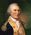
The decision to build a fort at Mount Independence was made on July 7, 1776. This happened at Fort Crown Point. Major General Philip Schuyler led the meeting. Just a week before, the American army had returned from a tough invasion of Canada. Many soldiers were sick with smallpox.
General Schuyler wrote to Commander-in-Chief George Washington. He said the land across from Ticonderoga was "remarkably strong." He believed it would be easy to defend against a large enemy army. It would also stop the enemy from moving further south.
Some officers didn't want to move from Crown Point. But on July 11, work began at the new site. Jeduthan Baldwin, a military engineer, led the work. Within a week, most of the army moved to Ticonderoga. Men worked hard at Mount Independence. They cleared forests and built huts and barracks.
The peninsula got its new name on July 28, 1776. Colonel Arthur St. Clair read the Declaration of Independence to the soldiers. That's why it became Mount Independence!
What the Fort Looked Like


Mount Independence was naturally strong for defense. Unlike Fort Ticonderoga, it was hard for invaders from Canada to attack. In late 1776, over 6,000 American soldiers were at Mount Independence. They were joined by temporary soldiers from other states. Many huts and barracks housed these troops.
A large wall with 28 cannons was built at the northern tip. Above that was the Citadel, or Horseshoe Battery. A star-shaped fort was built later on the highest ground.
A .25 miles (0.40 km) floating bridge connected Mount Independence and Ticonderoga. It was made of logs covered with planks. A bigger, stronger bridge was almost finished when the Americans left in July 1777.
A large hospital, 250 feet (76 m) long and 25 feet (7.6 m) wide, was being built. There were also storehouses, workshops, and a gunpowder lab. In spring 1777, new cannon batteries were built. These were designed by a Polish engineer named Tadeusz Kościuszko. During the British and German occupation, five blockhouses were started. These were to defend the east side from land attacks.
Summer and Fall 1776: Preparing for Battle
During the summer and fall of 1776, soldiers at Mount Independence worked hard. They prepared for a British invasion from Canada. At the same time, forts were built near old Fort Ticonderoga. In Skenesborough (now Whitehall, New York), a fleet of gunboats was built. These boats would defend the lake. Ships were also prepared with cannons at Mount Independence.
By late October 1776, over 13,000 soldiers defended the forts. This made the area one of the biggest population centers in the new country.

Major General Horatio Gates commanded the troops at Mount Independence and Ticonderoga. He reported to General Philip Schuyler. Brigadier General Benedict Arnold also served here. He later commanded the Lake Champlain fleet.
On October 11, 1776, a battle happened near Valcour Island. The American fleet was badly damaged but escaped. However, most ships were destroyed over the next two days. British forces then took over Fort Crown Point.
The American soldiers expected an attack at any moment. They prepared for battle. "Everyone works as hard as possible for an approaching battle," one person wrote. "Our work goes on day and night."
On October 28, British ships came near the forts. John Trumbull, a young officer, described the scene. He said the land on both sides of the lake was "crowned with redoubts and batteries." They were full of cannons and flags. Over 13,000 American soldiers were ready. The British ships left at sunset. Within a few days, all British forces went back to Canada.
Winter 1776–1777: A Tough Time

Colonel (later Brigadier General) Anthony Wayne commanded Mount Independence and Ticonderoga during the winter of 1776–1777. The number of soldiers dropped to fewer than 3,000 in December. By mid-February, there were fewer than 1,200.
There were big plans for building during winter. But just surviving was hard. Men cut down trees for firewood. They even took apart empty huts for fuel. Many soldiers got sick. Rations were not enough. General Wayne said the men lacked "every necessary except flour and bad beef." To keep order, he made troops shave and powder their hair. Then they marched for hours on the frozen lake.
As spring came, Wayne kept asking for more men and supplies. He wrote to General Schuyler, asking him to "rouse the public officers" to send help. He warned there was "not one moment to spare."
Spring 1777: Last Preparations

Work sped up in late March when engineer Jeduthan Baldwin returned. The Great Bridge connecting Mount Independence and Ticonderoga was a big project. Large wooden structures were built on the ice. Then they were pulled into holes cut in the frozen lake. Later, they were floated into place. Eventually, 22 of these structures, filled with stone, rose 10 feet (3.0 m) above the water.
Mount Independence and Ticonderoga had several commanders that spring. Finally, on June 12, Major General Arthur St. Clair took charge. By mid-June 1777, only 2,000 healthy American soldiers defended the forts. The defenses stretched 3.5 miles (5.6 km). St. Clair later wrote that if his men stood in a single line, they would "scarcely be within the reach of each other's voices."
General Schuyler thought about leaving the Ticonderoga side of the lake. The lines were too spread out. After a meeting on June 20, work increased on Mount Independence. Cannons and supplies were moved there. This was in case they had to leave Ticonderoga.
By late June, Americans knew the British were coming with a large force. Lieutenant General John Burgoyne had 8,000 British and German soldiers. He also had 138 cannons for the attack.
On July 2, the American position at Ticonderoga began to weaken. The British put cannons on a high hill to the north. German troops marched east to cut off Mount Independence. They aimed to take the land between East Creek and Lake Champlain.
On July 5, British gunners started building a cannon battery on Mount Defiance. This mountain overlooked both Mount Independence and Ticonderoga. Historians still debate how much this British cannon helped the Americans decide to leave. But that afternoon, a meeting of officers agreed to abandon Ticonderoga first, then Mount Independence.
The Retreat

The American retreat was planned for midnight, July 5–6. It was supposed to be silent, with no fires or lights. However, Brigadier General Matthias Alexis Roche de Fermoy burned his house on Mount Independence. This alerted the British to the retreat.
Healthy soldiers left Mount Independence just before dawn on July 6. They took the Mount Independence-Hubbardton Military Road. This path had been cut through the forest the fall before. The sick and wounded went by boat to Skenesborough. Supplies and cannons also went by boat. The American boats on the lake included six warships and about 200 smaller boats.
The British quickly followed. They crossed the floating bridge and took the forts on Mount Independence. British ships broke through the bridge. They followed the American boats to Skenesborough. That afternoon, they destroyed the rest of the American fleet. They also captured cannons and supplies. Brigadier General Simon Fraser and about 1,200 men chased the Americans on foot. The next morning, July 7, they met at the Battle of Hubbardton. This battle helped the main American army escape.
British and German Occupation
After the Americans left, British and German troops occupied Mount Independence. Wounded American prisoners from the Battle of Hubbardton were treated in the new hospital. Over 600 German soldiers defended the forts. Brigadier General Henry Watson Powell was in charge.
On September 18, Americans surprised Ticonderoga. This attack is known as Brown's Raid. Mount Defiance was taken by Captain Ebenezer Allen. Two hundred ninety-three British soldiers were captured. One hundred eighteen American prisoners were freed. Old Fort Ticonderoga was in danger.
The attack on Mount Independence was led by Colonel Samuel Johnson. Shots were fired, but the British ignored a surrender note. One British officer laughed at the American effort. "It is an undeniable truth that the Mount was never attacked by the Rebels otherwise than by paper," he wrote.
The Americans left on September 21. On November 8, after Burgoyne surrendered at Saratoga, the British and German forces left. They took what they could. They threw other supplies in the lake. They burned barracks, houses, and bridges. They disabled about 40 cannons. Then they retreated to Canada.
After the War: A Historic Site


It's possible that George Washington visited Mount Independence in summer 1783. This was after the fighting stopped but before the peace treaty was signed. In 1785, Matthew Lyon, who later became a U.S. congressman, took old cannons and scrap iron from the site. He used them for his iron forge.
Mount Independence became a place for early tourists. Future U.S. presidents Thomas Jefferson and James Madison might have visited in 1791. Historian Benson J. Lossing visited in 1853. He said the Mount was covered with new trees, except for the old parade grounds.
For many years, Mount Independence was farmland. People used it for sheep, cattle, and making maple syrup. Maple sugaring still happens there today!
In 1911, Stephen Pell bought 113 acres (46 ha) at the northern end of Mount Independence. Starting in 1961, the State of Vermont began buying land at the southern end. Today, the Fort Ticonderoga Association and the Vermont Division of Historic Preservation work together to care for the Mount.
In 1996, the Vermont Division of Historic Preservation opened a Visitor Center and museum. It is at the southern end of the Mount.
Images for kids
-
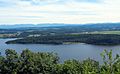
Mount Independence, Orwell, Vermont, as seen from across Lake Champlain
-
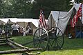
Revolutionary War reenactors camp at Mount Independence
-
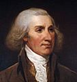
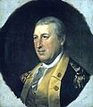
Major General Philip Schuyler
-
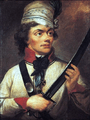
Thaddeus Kościuszko
-
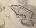
A map of Mount Independence as surveyed by British assistant engineer Lt. Charles Wintersmith in 1777
-
Major General Horatio Gates commanded in the summer and fall of 1776.
-
Anthony Wayne commanded the Lake Champlain forts during the winter of 1776–1777.
-
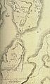
The map of the Lake Champlain forts used at the court-martial of General Arthur St. Clair following his decision to abandon Ticonderoga and Mount Independence.
-
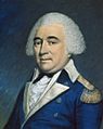
Major General Arthur St. Clair ordered the retreat from the forts.
-
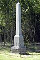
A monument erected in 1908 by the local chapter of the DAR.
-
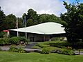
The Visitor Center and Museum at the Mount Independence Historic Site.
