Huriawa Peninsula facts for kids
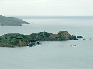
Huriawa, also called Huriawa Peninsula or Karitane Peninsula, is a piece of land that sticks out into the sea in Otago, New Zealand. It's about 35 kilometres north of Dunedin city. You can find it right next to the small town of Karitane.
This peninsula is very rocky and steep. It stretches out about 1000 metres (that's 1 kilometre!) from the main land. It's located near where the Waikouaiti River meets the sea. The narrowest part that connects it to Karitane is only about 90 metres wide.
The name huriawa comes from the Māori language. It means "turning river." This is because the Waikouaiti River used to flow into the sea on the south side of the peninsula. Now, it flows out on the north side.
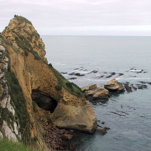
The ocean side of Huriawa has tall, steep cliffs. You can also see cool rock formations and blowholes there. A blowhole is a hole in the rock where sea water shoots up like a geyser! The side facing the river is not as rough, but it's still quite steep. Across the river, there's a big sandspit that forms the end of Waikouaiti Beach.
On the narrow strip of land connecting the peninsula, you'll find the Karitane cemetery. There's also a special memorial. It marks the spot where the first Christian sermon in Otago was given. This happened on May 17, 1840, by a person named Rev. James Watkin.
The western part of the peninsula has a few houses. The most famous one is Kingscliff House, which belonged to Sir Truby King. The rest of the peninsula, about four-fifths of it, is a special historic reserve.
Contents
Exploring Huriawa Peninsula
Huriawa Peninsula is a great place to visit. It's a historic reserve that covers about 13.32 hectares (that's about 33 acres). The public can visit this area. There's a walking track that goes in a loop, about 2.5 kilometres long. It's a good way to explore the area and see the amazing views.
The Huriawa Pā Site
The historic reserve is where a very important Māori fort, called a pā, once stood. This pā was known as Te Pa a Te Wera. It was a major coastal fort. People believe it was built by a Kai Tahu chief named Te Wera. This happened just before Captain James Cook visited New Zealand in the late 1700s.
The pā was very strong because of its location. It was hard to reach, which made it difficult for enemies to attack. It also had its own natural spring, called Te Punawai a Te Wera. This spring provided fresh water, which was very important during a siege.
The Famous Siege of Huriawa
One of the most famous events here was a six-month siege of the pā. A siege is when an army surrounds a place to try and make the people inside surrender. This siege was led by Te Wera's cousin, Taoka. It likely happened in the mid-1700s. This event is one of the most well-known stories from the Otago coast before European settlers arrived.
The siege of Huriawa was one of many battles between Chief Te Wera and Chief Taoka. Their conflicts happened all along the coastline, from Timaru down to the mouth of Otago Harbour.
Who Owns and Manages Huriawa Today?
The land title for Huriawa was given back to the Kai Tahu iwi (a Māori tribe) in 1998. This was part of their Waitangi Tribunal land claim settlement with the New Zealand government. Today, Huriawa is managed together by Kāti Huirapa Rūnaka ki Puketeraki and the New Zealand Department of Conservation. They work to protect this special place for everyone to enjoy.
 | DeHart Hubbard |
 | Wilma Rudolph |
 | Jesse Owens |
 | Jackie Joyner-Kersee |
 | Major Taylor |


