Hurricane John (1994) facts for kids
| Typhoon (JMA scale) | |
|---|---|
| Category 5 super typhoon (SSHWS) | |

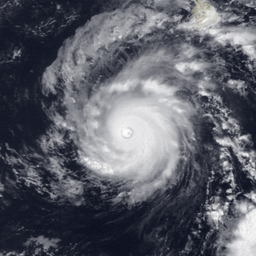
Hurricane John near peak intensity.
|
|
| Formed | August 11, 1994 |
| Dissipated | September 10, 1994 |
| Highest winds | 10-minute sustained: 155 km/h (100 mph) 1-minute sustained: 280 km/h (175 mph) |
| Lowest pressure | ≤ 929 hPa (mbar); 27.43 inHg |
| Fatalities | 0 |
| Damage | $15 million (1994 USD) |
| Areas affected | Hawaii, Johnston Atoll |
| Part of the 1994 Pacific hurricane season 1994 Pacific typhoon season |
|
Hurricane John was a very special tropical cyclone that lasted for an amazing 31 days. It holds the record for being the longest-lasting tropical cyclone ever seen. It traveled across the Eastern Pacific, then into the Western Pacific, and even came back to the Central Pacific!
Contents
How Hurricane John Began
Hurricane John started as a "tropical wave" on July 25, 1994. This was a low-pressure area that moved off the coast of Africa. It traveled all the way across the Atlantic Ocean.
By August 8, it reached the Eastern Pacific Ocean. It slowly got stronger and became a "Tropical Depression" on August 11. This was about 300 miles (480 km) south of Acapulco, Mexico. Later that same day, it grew into a "Tropical Storm" and was named John.
John Becomes a Hurricane
A large area of high pressure in the Northeastern Pacific Ocean pushed Tropical Storm John towards the west. For a while, strong winds high in the atmosphere kept John from getting much stronger.
But on August 19, these strong winds weakened. This allowed John to gain power. On August 20, it officially became a hurricane. Later that day, it grew into a "major hurricane" and moved into the Central Pacific Ocean.
Reaching Peak Strength
Hurricane John kept getting stronger. On August 23, it reached its strongest point with winds of about 175 miles per hour (280 km/h). At this time, it was passing about 300 miles (480 km) south of Hawaii.
Even though it didn't hit Hawaii directly, the hurricane caused big waves and heavy rains on the islands. Air Force planes flew into the storm to check its strength during these days.
Journey to Johnston Atoll and Beyond
After its peak, John started to weaken a bit. On August 26, it was a weaker hurricane. It then passed just north of Johnston Atoll, a small island. It caused some damage there.
However, conditions changed again, and John got stronger once more! It became a powerful Category 4 hurricane with winds of 135 miles per hour (217 km/h). But then, strong winds high up in the atmosphere weakened it again.
John then crossed the International Date Line. When a hurricane crosses this line from east to west, it changes its name to a "typhoon." So, Hurricane John became Typhoon John.
The Final Days of John
Typhoon John continued to weaken. By August 31, it was a tropical storm, and by September 2, it was just a tropical depression. It drifted eastward for a while.
Then, John made a loop and started moving northwest, slowly getting stronger again. On September 7, another weather system pulled the storm to the northeast. On September 8, John moved back into the Central Pacific Ocean and became a hurricane again.
John stayed a hurricane for another day. But on September 10, strong winds weakened it back into a tropical storm. Finally, John changed into an "extratropical" storm (meaning it lost its tropical features) in the North Central Pacific. It disappeared later that day, after its record-breaking 31-day journey.
Images for kids
See also
 In Spanish: Huracán John (1994) para niños


