Hurricane River facts for kids
Quick facts for kids Hurricane River |
|
|---|---|

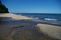
Mouth of the Hurricane River at Lake Superior
|
|
| Country | United States |
| Physical characteristics | |
| Main source | Burt Township, Alger County, Michigan 46°36′19″N 86°05′46″W / 46.60525°N 86.096°W |
| River mouth | Lake Superior, Michigan 46°39′58″N 86°10′05″W / 46.66607°N 86.16794°W |
| Length | 6.4 mi (10.3 km) |
The Hurricane River is a 6.4-mile-long (10.3 km) river in Alger County in the Upper Peninsula of Michigan in the United States. It empties into Lake Superior in the Pictured Rocks National Lakeshore. There is a campground at the mouth of the river which is also the beginning of a trail that leads past various old shipwrecks to the historic Au Sable Lighthouse. The mouth of the river is also very near the eastern end of a stretch of relatively straight shoreline known as Twelvemile Beach.

All content from Kiddle encyclopedia articles (including the article images and facts) can be freely used under Attribution-ShareAlike license, unless stated otherwise. Cite this article:
Hurricane River Facts for Kids. Kiddle Encyclopedia.


