Idylwood, Virginia facts for kids
Quick facts for kids
Idylwood, Virginia
|
|
|---|---|

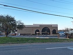
Office building along Route 29 in Idylwood
|
|

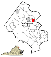
Location of Idylwood in Fairfax County, Virginia
|
|
| Country | United States |
| State | Virginia |
| County | Fairfax |
| Area | |
| • Total | 2.81 sq mi (7.3 km2) |
| • Land | 2.80 sq mi (7.3 km2) |
| • Water | 0.01 sq mi (0.03 km2) |
| Elevation | 463 ft (141 m) |
| Population
(2020)
|
|
| • Total | 17,954 |
| • Density | 6,412.14/sq mi (2,475.74/km2) |
| Time zone | UTC−5 (Eastern (EST)) |
| • Summer (DST) | UTC−4 (EDT) |
| FIPS code | 51-39448 |
| GNIS feature ID | 1495738 |
Idylwood is a special kind of community called a census-designated place (CDP). It is located in Fairfax County, Virginia, in the United States. In 2020, about 17,954 people lived there.
Idylwood first grew as a suburb along the Washington and Old Dominion Railroad line. Later, it developed further along Virginia State Route 7. Major roads like the Capital Beltway and I-66 were built in the 1960s and 1980s. The Orange Line of the Washington Metrorail system also opened in the 1980s.
These changes, along with the growth of nearby Tysons Corner into a big business area, led to new homes in Idylwood. Many apartment buildings, townhouses, and smaller single-family homes were built. The tall Idylwood Towers condominium also appeared. These newer homes are mostly north of I-66. South of I-66, you will still find mostly larger single-family homes.
Contents
Idylwood's Location and Size
Idylwood is in the eastern part of Fairfax County. It is located at coordinates 38.889722 degrees north and -77.205920 degrees west.
It shares borders with several other places:
- To the east is the city of Falls Church.
- To the north are Pimmit Hills and Tysons Corner.
- To the west is Dunn Loring.
- To the southwest is Merrifield.
- To the south is West Falls Church.
The Capital Beltway forms Idylwood's western edge. Virginia Route 7 (Leesburg Pike) is its northern border. U.S. Route 29 (Lee Highway) marks its southern border.
The United States Census Bureau says Idylwood covers about 2.81 square miles (7.28 square kilometers). Most of this area is land, with only a tiny part (0.01 square miles or 0.03 square kilometers) being water.
How Many People Live in Idylwood?
| Historical population | |||
|---|---|---|---|
| Census | Pop. | %± | |
| 1980 | 11,982 | — | |
| 1990 | 14,710 | 22.8% | |
| 2000 | 16,005 | 8.8% | |
| 2010 | 17,288 | 8.0% | |
| 2020 | 17,954 | 3.9% | |
| source: | |||
In 2000, there were 16,005 people living in Idylwood. These people lived in 6,560 households. About 3,831 of these were families. The population density was about 5,618 people per square mile.
The people living in Idylwood come from many different backgrounds. In 2000, about 16.38% of the population was Hispanic or Latino.
The average household had about 2.44 people. The average family had about 3.04 people. About 26.6% of households had children under 18 living there.
The median age in Idylwood was 33 years old. This means half the people were younger than 33, and half were older.
Businesses and Jobs
The company USIS used to have its main office in Idylwood. This shows that Idylwood has been home to important businesses.
Schools in Idylwood
Public schools in Idylwood are managed by Fairfax County Public Schools. One of the high schools, George C. Marshall High School, is located right in Idylwood.
Fun Places and Parks
Idylwood has places for outdoor fun and sports.
- The Fairfax County Park Authority runs the Jefferson District Golf Course. This golf course is in the southwest part of Idylwood.
- Idylwood Park is another county park. It is located in the western part of Idylwood, north of I-66. This park has fields for baseball, softball, and soccer. It also has courts for basketball and tennis.
See also
 In Spanish: Idylwood (Virginia) para niños


