Ikatan Bay facts for kids
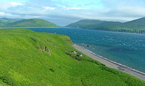
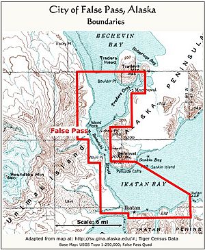
Ikatan Bay is a body of water in the U.S. state of Alaska. It is an important waterway. The bay and Isanotski Strait help separate Unimak Island from the Alaska Peninsula. In the past, smaller boats used this route. They traveled from ports like Puget Sound all the way to St. Michael on the Yukon River.
Contents
Exploring Ikatan Bay: Alaska's Waterway
Ikatan Bay is located on the north side of the Ikatan Peninsula. It is about 3.75 miles (6 km) wide. The bay stretches about 5 miles (8 km) in a southwest direction. It is usually calm, without big waves. The only time it gets rough is when winds blow from the north to the east.
Islands and Features
There are interesting features within Ikatan Bay. Sankin Island is one of them. It lies about 1 mile (1.6 km) from the north side of the bay. This island is tall and has a rounded, grassy top. A rocky reef stretches from Sankin Island towards the nearby land. Northwest of Sankin Island, you'll find Sankin Bay.
Land and Water Connections
The southwest end of Ikatan Bay is close to Otter Cove. They are separated by a narrow strip of land called an isthmus. This land is only about 20 to 30 feet (6 to 9 meters) high. A river flows into Ikatan Bay right in the middle of this low land. There is also a hidden sandbar, or spit, near the river's mouth. This spit drops off quickly into very deep water.
Safe Places to Anchor
Boats need safe places to stop and rest. Ikatan Bay offers good spots for anchoring. One good place is on the west side of Ikatan Point. Another safe spot is on the south side of the bay. Here, boats can anchor in about 9 fathoms (54 feet or 16 meters) of water. The bottom is sandy and muddy, offering good grip for anchors. This spot protects boats from winds coming from the southeast to the southwest.
The best place to anchor in Ikatan Bay, especially during strong southerly winds, is on its south side. This area is off the low land that leads to Dora Harbor. You can also anchor on the north side of the bay. This spot is about 2.25 miles (3.6 km) west of Sankin Island. The water here is about 10 fathoms (60 feet or 18 meters) deep with a sandy bottom. It protects boats from normal northerly winds. However, it is open to strong easterly and southerly winds.
Isanotski Strait and Nearby Villages
Isanotski Strait connects to Ikatan Bay. Its southern entrance is at the northwest end of Ikatan Bay. This strait is a narrow passage of water. About 7 miles (11 km) up the eastern side of Isanotski Strait, you will find Traders Cove. This is another good place for boats to anchor. A mission and native village called Morzhovoi is located on the south side of the strait.
Tides and Currents
The water level in Ikatan Bay changes with the tides. The average difference between high tide and low tide is about 4.5 feet (1.4 meters). This is called the mean rise and fall of tides. In the narrow southern part of Isanotski Strait, the water moves very fast. The tidal currents can reach speeds of 7 to 9 miles per hour (11 to 14.5 km/h) or even more. People say there is almost no calm period when the current stops. The current usually changes direction about three hours after high or low tide in Ikatan Bay.
 | Kyle Baker |
 | Joseph Yoakum |
 | Laura Wheeler Waring |
 | Henry Ossawa Tanner |


