Illa de Tagomago facts for kids

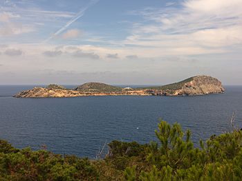
The island of Tagomago
|
|
| Geography | |
|---|---|
| Location | Balearic Sea |
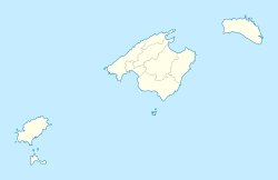
| Coordinates | 39°02′00″N 1°39′00″E / 39.03333°N 1.65°E |
| Archipelago | Balearic Archipelago |
| Administration | |
| Autonomous Community | Balearic Islands |
| Province | Ibiza |
| Municipality | Santa Eulària des Riu |
Illa de Tagomago is a small, private island located off the east coast of Ibiza. Both islands are part of Spain. Being a private island means that it is owned by a person or a family, not by the public or the government.
Contents
About Tagomago Island
Illa de Tagomago is about 1,525 meters (or about 1 mile) long and 113 meters (about 370 feet) wide. The island is mostly rocky. It has a small port and a lighthouse on its southeast side.
The Tagomago Lighthouse
The lighthouse on Tagomago Island was built in 1913. It is a very important landmark for ships sailing between Ibiza, Palma de Mallorca, and Barcelona. The light from the lighthouse is 86.3 meters (about 283 feet) above sea level. The lighthouse structure itself is 20.4 meters (about 67 feet) tall.
Who Owns Tagomago?
The island of Tagomago is owned by a Spanish family. There is a small place for visitors to stay on the island. Many famous people, including politicians and celebrities, often visit this special spot.
History of the Name
The name Tagomago likely comes from "rock Mago." This refers to Mago Barca, who was the brother of the famous Carthaginian general Hannibal. During the time when Muslims ruled parts of Spain, the island was known as Taj Umayu.
Fun Fact
The second album by the German band Can, called Tago Mago, was named after this island!
See also
 In Spanish: Isla Tagomago para niños
 | Leon Lynch |
 | Milton P. Webster |
 | Ferdinand Smith |


