Balearic Sea facts for kids
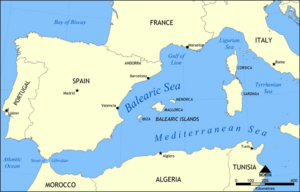
The Balearic Sea is a part of the big Mediterranean Sea. It is located between the Balearic Islands and the coast of Spain. In Catalan and Spanish, people call it Mar Balear. A major river called the Ebro flows into this sea.
Contents
Exploring the Balearic Islands
The Balearic Sea is home to the beautiful Balearic Islands. These islands are divided into two main groups. They are the Gimnesias in the northeast and the Pitiusas in the southwest.
Gimnesias Islands
Pitiusas Islands
Where is the Balearic Sea Located?
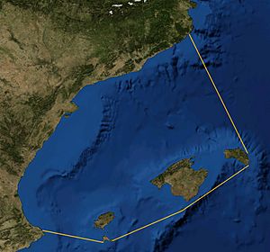
The International Hydrographic Organization helps define the exact borders of seas around the world. They describe the Balearic Sea as being between the Balearic Islands and the coast of Spain.
Its southwestern border stretches from Cape Sant Antoni, Spain in the Valencian Community to Cape Berberia on Formentera.
To the southeast, the border follows the southern coast of Formentera. Then it goes from Punta Rotja to the southern tip of Cabrera, Balearic Islands. It continues to Illa de l'Aire, which is off the southern end of Menorca.
On the northeast side, the border runs along the east coast of Menorca up to Cap Favaritx. From there, it draws a line to Cape Sant Sebastià in Catalonia.
See also
 In Spanish: Mar Balear para niños
- Gulf of Cádiz
- Gulf of Lion
 | Kyle Baker |
 | Joseph Yoakum |
 | Laura Wheeler Waring |
 | Henry Ossawa Tanner |


