
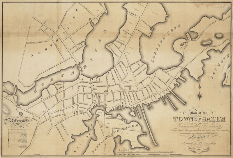
Image: 1820 Salem Massachusetts map bySaunders BPL 12094

Size of this preview: 800 × 541 pixels. Other resolutions: 320 × 216 pixels | 1,052 × 711 pixels.
Original image (1,052 × 711 pixels, file size: 1.2 MB, MIME type: image/png)
Description: Plan of the town of Salem in the commonwealth of Massachusetts, from actual surveys, made in the years 1796 & 1804; with the improvements and alterations since that period as surveyed
Title: 1820 Salem Massachusetts map bySaunders BPL 12094
Credit: http://maps.bpl.org/details_12094
Author: Saunders, Jonathan Peele
Usage Terms: Public domain
License: Public domain
Attribution Required?: No
Image usage
The following 18 pages link to this image:
- Bridge Street Neck Historic District
- Charter Street Historic District
- Chestnut Street District
- City Hall (Salem, Massachusetts)
- Downtown Salem District
- Gardner–Pingree House
- Gedney and Cox Houses
- Hamilton Hall (Salem, Massachusetts)
- John Ward House (Salem, Massachusetts)
- Pickering House (Salem, Massachusetts)
- Ropes Mansion
- Salem, Massachusetts
- Salem Athenaeum
- Salem Common Historic District (Salem, Massachusetts)
- Salem Maritime National Historic Site
- Stephen Phillips House
- The Witch House
- Timeline of Salem, Massachusetts

All content from Kiddle encyclopedia articles (including the article images and facts) can be freely used under Attribution-ShareAlike license, unless stated otherwise.