
Image: Fort-Jefferson Dry-Tortugas

Size of this preview: 800 × 531 pixels. Other resolutions: 320 × 212 pixels | 1,200 × 796 pixels.
Original image (1,200 × 796 pixels, file size: 1.01 MB, MIME type: image/jpeg)
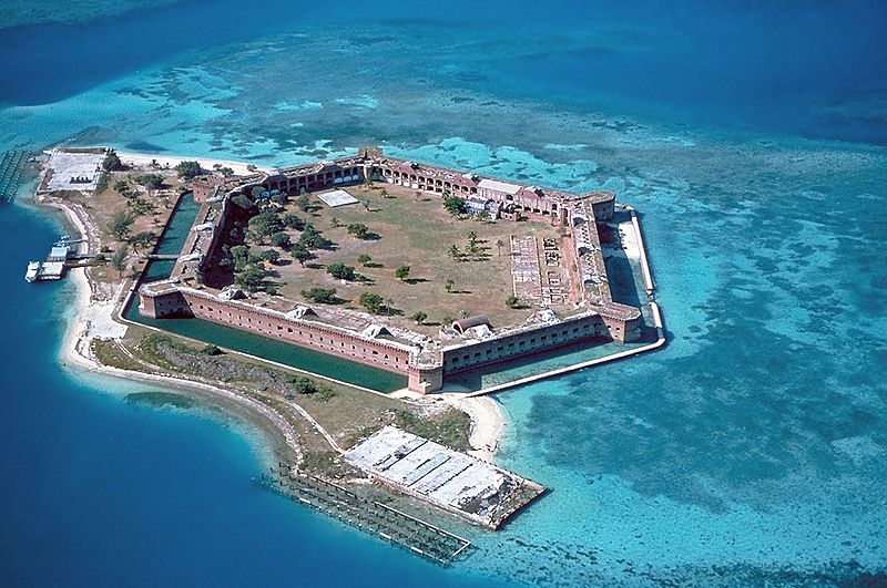
Description: Fort Jefferson at the Dry Tortugas. The clear waters in shallow areas surrounding the fort, seen easily in the photo, are popular for snorkeling and scuba diving. Visible on the right side of the image is a breach of the sea wall caused by the direct strike of Hurricane Charley in August 2004. Camera location 24° 37′ 55″ N, 82° 52′ 03″ W View this and other nearby images on: OpenStreetMap - Google Earth 24.631944; -82.867500
Title: Fort-Jefferson Dry-Tortugas
Credit: U.S. National Park Service [1]; English Wikipedia, original upload 2 March 2005 by Brian0918
Author: U.S. National Park Service
Usage Terms: Public domain
License: Public domain
Attribution Required?: No
Image usage
The following 11 pages link to this image:
- Dry Tortugas National Park
- Fort Jefferson (Florida)
- Hexagon
- List of National Historic Landmarks in Florida
- List of ghost towns in Florida
- List of national parks of the United States
- Maritime history of Florida
- Military base
- Moat
- National Register of Historic Places listings in Monroe County, Florida
- United States National Register of Historic Places listings

All content from Kiddle encyclopedia articles (including the article images and facts) can be freely used under Attribution-ShareAlike license, unless stated otherwise.