kids encyclopedia robot

List of ghost towns in Florida facts for kids

Kids Encyclopedia Facts
Stiltsville
A view of Stiltsville, Florida, from the Cape Florida Light
Aladdin City Ad
An advertisement showing the layout plans for Aladdin City, Florida, from the Homestead Leader
BrewsterPowerPlant1920
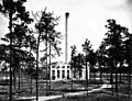
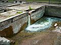
The power plant in Brewster, Florida, 1920
Flamingo Visitor Center FL1
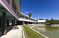
The visitor's center for Flamingo, Florida
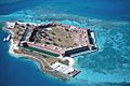
Fort-Jefferson Dry-Tortugas
Fort Jefferson, Florida is a massive but unfinished coastal fortress. It is the largest masonry structure in the Americas, and is composed of over 16 million bricks. The fort is located on Garden Key in the lower Florida Keys within the Dry Tortugas National Park, about 70 miles (110 km) west of the island of Key West.
Fort Lonesome FL CR 39 SR 674 inter01
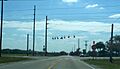
The intersection of SR 674/CR 39 at Fort Lonesome, Florida
Indian Key
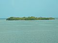
Indian Key, Florida, now uninhabited
Hampton Springs FL hotel07
Site of the old Hampton Springs Hotel at Hampton Springs, Florida
Kerr City Hist Dist po01
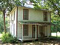
The former post office at Kerr City, Florida

This is an incomplete List of ghost towns in Florida sortable by town or county.

Town County Latitude/Longitude
Acron Lake 29°0.1'N 81°31.2'W
Acton Polk 28°3.2'N 81°56.0'W
Agricola Polk 27°47.3'N 81°53.3'W
Aladdin City Miami-Dade 25°34.6'N 80°27.2'W
Allenhurst Brevard 28°44.1'N 80°45.4'W
Andytown Broward 26°8.7'N 80°26.6'W
Anona Pinellas 27°53.6'N 82°49.9'W
Apix Palm Beach 26°56.6'N 80°20.6'W
Apoxsee Osceola 27°48.0'N 80°56.4'W
Arlington Citrus 28°52.2' 82°21.7'W
Atsena Otie Key Levy 29°7.3'N 83°1.6'W
Aurytown Glades 26°50.0'N 81°17.8'W
Aurytown Pinellas ~28°4.8'N 82°49.9'W
Balm(inhabited) Hillsborough 27°44.5'N 82°12.2'W
Bereah Polk 27°39.6'N 81°37.5'W
Barrsville Columbia ~30°0'N ~82°35'W
Basinger Okeechobee 27°23.3'N 81°2.0'W
Bay Harbor (industrial) Bay 30°8.7'N 85°37.3'W
Bayview Lake 28°32.7'N 82°38.6'W
Bayview (inhabited) Pinellas 27°27.5'N 82°42.5'W
Bean City Palm Beach 26°40.9'N 80°45.7'W
Bereah Polk 27°39.6'N 81°37.5'W
Bermont Charlotte 26°56.8'N 81°45.7'W
Bethany Manatee 27°28.4'N 82°16.2'W
Birdon Collier 25°54±'N 81°18.6'W
Boyette Hillsborough 27°49.1'N 82°13.4'W
Brewster Polk 27°45.1'N 81°58.4'W
Bryant Palm Beach 26°50.9'N 80°36.8'W
Buchanan Hardee 27°24.7'N 81°47.7'W
Bullowville Flagler ~21°25'N ~81°09'N
Bunce Village Pinellas 27°38.7'N 82°44.3'W
Bunkerhill Manatee 27°35.7'N 82°12.4'W
Castor Town Hillsborough 27°35±'N 82°45.7'W
Centralia Hernando 28°36.9'N 82°32.7'W
Campville Alachua 29°39.9'N 82°7.1'W
Chetwynd Lake 28°52.6'N 81°55.0'W
Chevelier Monroe T54S R31E
Chicora Polk 27°43.8'N ~81°59'W
Chokoloskee (inhabited) Collier 25°48.8'N 81°21.6'W
Chosen Palm Beach ~26°42'N 80°46.8'W
Citrus Center Glades 26°48.8'N 81°14.9'W
Clifton Brevard 28°45.0'N 80°46.2'W
College Hill Hardee 27°37.7'N 81°52.3'W
Columbus Suwannee 30°23.1'N 83°10.4'W
Conant Lake 28°56.3'N 81°55.7'W
Cornwell Highlands 27°23.7'N 81°9.4'W
Cosme (inhabited) Hillsborough 28°06.5'N 82°34.4'W
Crewsville Hardee 27°25.3'N 81°35.0'W
Cromanton (Tyndall Air Force Base) Bay 30°7.0'N 85°37.6'W
Croom Hernando 28°35.4'N 82°13.7'W
Cutler Miami-Dade 25°36.9'N 80°18.6'W
Deep Lake Collier 26°02.5'N 81°20.6'W
Deer Park (inhabited) Osceola 28°5.5'N 80°53.9'W
East Goose Creek Wakulla 30°6.3'N 84°15.7'W
Eden (inhabited) Saint Lucie 27°16.5'N 80°14.6'W
Edgeville Manatee 27°18.9'N 82°6.5'W
Eldora Volusia 28°54.6'N 80°49.2'W
Electra Marion 29°7.7'N 81°53.3'W
Ellaville Madison 30°23.2'N 83°10.4'W
Englewood Orange 28°23.7'N 81°30.2'W
Espanola (inhabited) Flagler 29°30.4 81°18.5'W
Ethel Lake 28°50.1'N 81°26.6'W
Fairmount Citrus
Fivay Pasco 28°19.9'N 82°38.4±'W
Flamingo Monroe 25°8.5'N ~81°0'W
Fontaine Brevard 28°45.4'N 80°54.4'W
Fort Basinger Highlands 27°21.7'N 81°3.2'W
Fort Chokonikla Hardee 27°37.2'N 81°48.5'W
Fort Dade Hillsborough 27°35.8'N 82°45.7'W
Fort Dallas Miami Dade 25°46.6'N 80°12.1'W
Fort Denaud (inhabited) Hendry 26°44.7'N 81°27.9'W
Fort DeSoto Pinellas 27°38.2'N 82°44.2'W
Fort Drum Okeechobee 21°37.6'N 80°48.4'W
Fort Jefferson Monroe 24°37.7'N 82°52.4'W
Fort King Marion 29°11.2'N 82°5.0'W
Fort Kissimmee Polk/Highlands 27°35.5'N 81°9.4'W
Fort Lonesome Hillsborough 27°42.3'N 81°8.3'W
Fort Mose St. Johns 29°55.8'N 81°19.3'W
Fort Pickens Escambia 30°19.5'N 87°16.8'W
Freeman Hernando ~28°34'N ~82°33'N
Fruitcrest Palm Beach 26°37.8'N 80°44.9'W
Gaiter Marion 29°0.5'N 82°20.6'W
Gamble Plantation Manatee 27°32'N 82°32'W
Gardena Palm Beach 26°37.0'N 80°50.7'W
Gardner Hardee 27°21.1'N 81°48.1'W
Garfield Volusia 28°52.1'N 81°13.5'W
Geerworth Palm Beach 26°40.7'N 80°32.3'W
Gillette Manatee 27°36.1'N 82°31.7'W
Gladecrest Palm Beach 26°37.8'N 80°34.1'W
Goodno Glades 26°46.1'N 81°18.7'W
Green Pond Polk 28°18.6'N 81°53.9'W
Greenbay Polk 27°50.2'N 81°55.5'W
Gulf City (inhabited) Hillsborough 27°42.3'N 82°27.8'W
Hague (inhabited) Alachua 29°46.2'N 82°25.3'W
Haile Alachua 37°41.4'N 82°34.4'W
Hall City Glades 26°52.7'N 81°19.6'W
Hampton Springs Taylor 30°05.0'N 83°39.1'W
Hardaway Gadsden 30°37.9'N 84°44.2'W
Hawkinsville Lake 29°2.2'N 81°25.2'W
Heidtville Marion ~29°3.6'N ~82°20.6'W
Helen Leon 30°18.5'N 84°24.0'W
Hicoria Highlands 27°9.1'N 81°21.2'W
Hilolo Okeechobee 27°26.9'N 80°46.3'W
Holopaw (inhabited) Osceola 28°8.2'N 81°4.6'W
Hopewell Hillsborough 27°55.7'N 82°07.5'W
Hopkins Brevard 28°4.2'N 80°35.9'W
Illahaw Osceola 28°1.1'N 81°1.9'W
Indian Key Monroe 24°53'N 80°41'W
Indiantown (inhabited) Martin 27°1.8'N 80°29.0'
Island Grove Alachua 29°27.2'N 82°6.4'W
Jane Jay Polk ~27°40.3'N ~81°49.2'W
Jerome (inhabited) Collier 25°59.9'N 81°20.8'W
Jessamine Pasco 28°24.8'N 82°16.2'W
Juliette Marion 29°6.2'N 82°26.4'W
Juno(Inhabited) Palm Beach 26°50.6'N 80°3.6'W
Kenansville Osceola 80°59.3'N 27°52.6'W
Kerr City Marion 29°22.5'N 81°46.9'W
Kicco Osceola
Kismet Lake ~29°2.5'N ~81°37.5'W
Koreshan(Inhabited) Lee 26°26.0'N 81°49.0'W
Kreamer Island Palm Beach 26°45.4'N 80°44.0'W
Lake Fern (inhabited) Hillsborough 28°8.9'N 82°34.8'W
Lawtey (inhabited) Bradford 30°2.6'N 82°4.3'W
Leno Columbia 30°2.6'N 82°4.3'W
Limona (inhabited) Hillsborough 27°57.1'N 82°18.6'W
Linden Sumter 28°33.7'N 82°2.0'W
Liverpool DeSoto ~27°2.7'N ~81°58.2'W
Locosee Osceola 27°45.3'N 80°54.7'W
Lulu (inhabited) Columbia 30°6.4'N 82°29.5'W
Mabel Sumter 28°34.7'N 81°58.4'W
Magnolia Wakulla 30°13.2'N 84°10.5'W
Manasota Charlotte 27°0.8'N 82°24.2'W
Manhattan Manatee 27°23.1'N 82°19.2'W
Mannfield Citrus 28°47.0'N 82°26.6'W
Mars
Midland Polk 27°44.3'N 81°37.3'W
Minton's Corner Brevard 28°4.7'N 80°40.3'W
Modello (Dania Beach) Broward 26°3.0'N 80°8.8'W
Moffit Hardee 27°27.3'N 81°47.8'W
Montague Marion 29°9.0'N 82°4.4'W
Montbrook Levy 29°19.6'N 82°27.0'W
Muscogee Escambia 30°36.4'N 87°24.8'W
Naranja (inhabited) Miami-Dade 25°31.0'N 80°25.3'W
Narcoossee (inhabited) Osceola 28°17.9'N 81°14.3'W
Negro Fort Franklin 29°56.4'N 85°0.7'W
Neilson Polk 27°40.7'N 81°30.1'W
Newhall Glades ~26°51.1'N ~81°7.4'W
New Troy Lafayette 30°0.4'N 83°0.8'W
Newnansville Alachua 29°48.5'N 82°28.6'W
Newport Wakulla 30°12.0'N 84°10.8'W
Nittaw Osceola 27°57.2'N 81°0.0'W
Oakgrove Hernando
Okeelanta Palm Beach 26°36.6'N 80°42.7'W
Old Bethel Okaloosa 30°47.5'N 86°36.2'W
Old California
Old Providence Union 30°0.9'N 82°33.6'W
Old Town Lake 29°2.2'N 81°25.2'W
Old Venus Highlands 27°4.0'N 81°21.5'W
Olympia Martin 27°3.2'N 80°7.9'W
Ona Hardee 27°28.9'N 81°55.2'W
Orange Center Orange 28°23.7'N 81°30.2'W
Orleans Citrus ~25°47.5'N ~82°22.5'W
Orsino Brevard 28°31.6'N 80°39.8'W
Ortona Glades 26°48.7'N 81°18.9'W
Osceola Seminole 28°47.6'N 81°3.5'W
Oslo Indian River 27°35.2'N 80°22.8'W
Osowaw Junction Okeechobee 27°34.8'N 80°50.1'W
Old Venus Highlands
Palma Sola (inhabited) Manatee 27°30.7'N 82°37.9'W
Parmalee Manatee 27°22.3'N 82°13.2'W
Parramore Jackson 30°52.3'N 84°59.9'W
Pembroke (industrial) Polk 27°47.2'N 81°48.3'W
Perky Monroe 24°38.9'N 81°34.3'W
Peru Hillsborough 27°52.7'N 82°19.1'W
Peters Miami-Dade 25°35.9'N 80°21.2'W
Picnic Hillsborough 27°45.7'N 82°8.8'W
Picture City (inhabited) Martin 27°4.6'N 80°8.5'W
Pierce Polk 27°50.1'N 81°58.3'W
Pigeon Key Monroe 24°42.2'N 81°9.3'E
Pinecrest (inhabited) Monroe 25°39.7'N 80°18.5'W
Pine Level DeSoto 27°15.9'N 81°59.5'W
Pittman Lake 28°59.8'N 81°38.6'W
Pittsburg Polk 27°39.2'N 81°30.1'W
Popash Hardee ~27°30.8'N ~81°41.8'W
Port Leon Wakulla 30°7.9'N 84°11.7'W
Port Tampa (inhabited) Hillsborough 27°51.8'N 82°31.7'W
Prairie Ridge Okeechobee
Providence (inhabited) Union 30°0.2'N 82°32.9'W
Punta Rassa Lee 26°30.7'N 81°59.9'W
Quay Indian River 27°43.1'N 80°24.8'W
Rattlesnake (Tampa) Hillsborough 27°53.8 82°31.4'W
Renfro Springs Marion 29°3.4'N 82°28.4'W
Ridgewood Polk 27°53.4'N 81°54.8'W
Ringgold (inhabited) Hernando 28°39.1'N 82°26.8'W
Rital Hernando 28°31.3'N 82°13.0'W
Ritta Island Palm Beach 26°43.3'N 80°48.3'W
Rochelle Alachua 29°35.8'N 82°13.1'W
Rollestown Putnam 29.63 N 81.59 W
Romeo Marion 29°12.4'N 82°26.2'W
Rosewood Levy 29°14.4'N 82°55.9'W
Runnymede Osceola 28°15.9'N 81°14.7'W
Rye Manatee 27°30.8'N 82°22.1'W
Saint Annes Shrine Polk
Saint Catherine Sumter 28°36.7'N 82°8.3'W
Sampson City Bradford 29°55.0'N 82°12.3'W
Sand Cut Palm Beach
Sandy Manatee
Sardis Manatee 27°17.0'N 82°12.0'W
Sears Hendry 26°38.8'N 81°22.6'W
Sherman Okeechobee 27°12.6'N 80°45.2'W
Silver Palm (inhabited) Miami-Dade ~25°33.1'N ~80°26.7'W
Sisco Putnam ~29°31.14'N 81°37.31'W
Slavia Seminole 28°38.8'N 81°13.9'W
Slighville Lake
Shiloh Brevard 28°46.0'N 80°46.6'W
Snake Bight Monroe 25°10.1'N 80°52.7'W
Sparkman Charlotte
Spray Madison
Spruce Bluff Saint Lucie
St. Francis Lake 29°2.2'N 81°25.2'W
St. Joseph Gulf
Stage Pond Citrus 28°41.9'N 82°24.4'W
Stanton Marion
Stiltsville Miami-Dade 25°39.2'N 80°10.3'W
Sumica Polk 27°51.4'N 81°22.6'W
Sun City (inhabited) Hillsborough 27°40.7'N 82°28.7'W
Sweetwater Hardee 27°24.6'N 81°42.2'W
Tantie Okeechobee
Tarrytown Sumter 28°33.3'N 82°0.1'W
Tasmania Glades or Highlands
Tiger Bay Polk 27°45.6'N 81°50.9'W
Tillman (Palm Bay) Brevard 28°2.0'N 80°35.0'W
Tohopkee Osceola 28°13.5'N 81°4.6'W
Torrey (inhabited) Hardee 27°36.6'N 81°49.5'W
Traxler Alachua 29°52.2'N 82°32.3'W
Troy Lafayette 30°0.2'N 82°59.9'W
Utopia Okeechobee 27°1.9'N 80°41.8'W
Vandolah Hardee 27°30.9'N 81°55.6'W
Venus Highlands 27°4.0'N 81°21.5'W
Venus Palm Beach
Verna Manatee 27°23.2'N 82°16.1'W
Viana Citrus ~28°54'N ~82°27'W
Vicksburg Bay 30°19.5'N 85°39.9'W
Viking Saint Lucie 27°32.5'N 80°21.7'W
Villa City Lake 28°37.1'N 81°51.1'W
Vineland (inhabited) Orange 28°23.7'N 81°30.2'W
Vogt Springs Marion 29°3.4'N 82°28.4'W
Waterbury Manatee 27°26.7'N 82°18.2'W
Waveland Martin 27°16.1'N 80°12.4'W
Weedon Island Pinellas ~27°50.5'N ~82°36.2'W
Welchton (inhabited) Marion ~29°5.0'N ~81°59.5'W
Welcome (industrial) Hillsborough 27°51.9'N 82°5.2'W
West Tocoi Clay 29°51.0'N 81°37.4'W
Willow Manatee 27°38.6'N 82°20.8'W
Wilson (Kennedy S. C.) Brevard 28°38.6'N 80°41.8'W
Wiscon (inhabited) Hernando 28°32.0'N 82°27.6'W
Yamato Colony Palm Beach 26°24.6'N 80°5.4'W
Yukon Duval 30°14.1'N 81°41.9'W
Zana Martin 27°7.2'N 80°37.1'W
Zion (inhabited) Palm Beach 26°27.7'N 80°3.5'W
  • Note: some 19th-Century Florida maps show longitude west of Washington (WW), which is approximately 77°2.8' west of Greenwich (WG).
kids search engine
List of ghost towns in Florida Facts for Kids. Kiddle Encyclopedia.