
National Register of Historic Places listings in Monroe County, Florida facts for kids

Monroe County, Florida, is a special place known for its beautiful Florida Keys and the amazing Everglades National Park. It's also home to many important historical sites. These places are so special that they are listed on the National Register of Historic Places. This list helps protect buildings, objects, and areas that have played a big part in American history, architecture, archaeology, engineering, or culture.
There are 58 places in Monroe County that are on this important list. Four of these are even more special and are called National Historic Landmarks. Let's explore some of these cool historic spots!
Contents
- What is the National Register of Historic Places?
- Historic Buildings and Homes
- Important Forts and Military Sites
- Lighthouses and Shipwrecks
- Other Unique Historic Sites
- African Cemetery at Higgs Beach
- African Queen (boat)
- Sugarloaf Key Bat Tower
- Florida Keys Memorial
- Indian Key State Historic Site
- USCGC Ingham (WHEC-35)
- John Pennekamp Coral Reef State Park
- Key West Historic District
- Lignumvitae Key State Botanical Park
- Mud Lake Canal
- Overseas Highway and Railway Bridges
- Pigeon Key Historic District
- Veterans of Foreign Wars Walter R. Mickens Post 6021 and William Weech American Legion Post 168
- Western Union (schooner)
- Archaeological Sites
- Images for kids
What is the National Register of Historic Places?
The National Register of Historic Places is like a special club for important historical sites across the United States. It's managed by the National Park Service. When a place is added to the Register, it means it's recognized for its historical value. This helps to save these places for future generations to learn from and enjoy. It also means they might get special funding or protection to keep them safe.
Historic Buildings and Homes
Monroe County has many old buildings that tell stories of the past.
George Adderley House
The George Adderley House is located in Marathon. It was built by George Adderley, a Bahamian immigrant, in the early 1900s. This house is a great example of early pioneer life in the Florida Keys. It shows how people lived and built homes using local materials and techniques back then.

The Armory in Key West
In Key West, you can find The Armory. This building, located on White Street, was once used by the military. It's a strong, historic structure that reminds us of Key West's past as an important naval base.
.jpg)
Eduardo H. Gato House
The Eduardo H. Gato House is another beautiful historic home in Key West. Eduardo H. Gato was a very important person in Key West's history, especially in the cigar industry. His house shows the grand style of homes built by successful people in the late 1800s.

Ernest Hemingway House
One of the most famous houses in Key West is the Ernest Hemingway House. This was the home of the famous writer Ernest Hemingway in the 1930s. He wrote many of his well-known books here. It's now a museum where you can learn about his life and see the many cats that live there, some of which are descendants of Hemingway's own cat!

Harry S. Truman Little White House
The Little White House in Key West was once the winter home of President Harry S. Truman. He spent many vacations here and even conducted official business from this house. It's a fascinating place to see where a U.S. president relaxed and worked.

Old Post Office and Customshouse
The Old Post Office and Customshouse in Key West is a grand building that once handled mail and customs for ships coming into the port. Today, it's the Key West Museum of Art & History, where you can learn even more about the island's rich past.

Dr. Joseph Y. Porter House
The Dr. Joseph Y. Porter House belonged to a very important doctor in Key West. Dr. Porter was Florida's first state health officer and played a huge role in fighting diseases like yellow fever. His house is a reminder of his important work.

Sloppy Joe's Bar
Sloppy Joe's Bar on Duval Street is famous for being a favorite hangout of Ernest Hemingway. It's a lively spot that has been a part of Key West's social scene for many years.

Thompson Fish House, Turtle Cannery and Kraals
This unique site in Key West shows how important fishing and the turtle industry were to the island. The Thompson Fish House, Turtle Cannery and Kraals were places where fish were processed and turtles were kept before being used for food or other products. It's a look into a different time for the Keys.

U.S. Coast Guard Headquarters, Key West Station
The U.S. Coast Guard Headquarters, Key West Station is another historic building that highlights Key West's role in maritime safety and defense. It's located near the waterfront and has been important for protecting the waters around Florida.

Important Forts and Military Sites
Monroe County has several forts that were built to protect the coast.
Fort Jefferson
Fort Jefferson is a massive, unfinished coastal fortress located in the Dry Tortugas National Park, about 70 miles west of Key West. It's the largest brick masonry structure in the Americas! It was built in the 1800s to protect the shipping lanes in the Gulf of Mexico. It's a truly impressive sight.

Fort Zachary Taylor
Fort Zachary Taylor is another important fort in Key West. It was built in the mid-1800s and played a role in the American Civil War and the Spanish–American War. Today, it's a state park with a popular beach and a great place to learn about military history.

Martello Gallery-Key West Art and Historical Museum
The Martello Gallery-Key West Art and Historical Museum is located in one of the old Martello Towers, which were small defensive forts. This tower, the East Martello Tower, was built to protect Key West during the Civil War. Now, it's a museum and art gallery.

West Martello Tower
The West Martello Tower is another one of these historic defensive structures. Like its eastern counterpart, it was built for coastal defense. Today, it's home to the Key West Garden Club, featuring beautiful gardens within the old fort walls.

Lighthouses and Shipwrecks
The Florida Keys are known for their dangerous reefs, which led to many shipwrecks and the need for lighthouses.
Alligator Reef Light
The Alligator Reef Light is an offshore lighthouse near Islamorada. It was built to warn ships about the dangerous Alligator Reef. These lighthouses are important symbols of maritime safety.

American Shoal Light
The American Shoal Light is another offshore lighthouse, located southwest of Summerland Key. It's part of a group of lighthouses built to guide ships safely through the Florida Keys.

Carysfort Reef Light
The Carysfort Reef Light is one of the oldest lighthouses in the Florida Keys, located near Key Largo. It has helped countless ships avoid the reefs for many years.

Sand Key Light
The Sand Key Light is located southwest of Key West. This lighthouse has stood guard over the waters, helping sailors navigate the tricky channels.

Sombrero Key Light
The Sombrero Key Light is offshore from Marathon. It's another important lighthouse that has guided ships and prevented accidents in the waters of the Keys.

Historic Shipwrecks
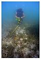
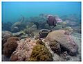
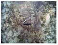
Many shipwrecks in Monroe County are also on the National Register. These include:
- The Angustias Shipwreck Site
- The Chaves Shipwreck Site
- The El Gallo Indiano Shipwreck Site
- The El Infante Shipwreck Site
- The El Rubi Shipwreck Site
- The Herrara Shipwreck Site
- The San Felipe Shipwreck Site
- The San Francisco Shipwreck Site
- The San Jose Shipwreck Site
- The San Pedro (shipwreck)
- The Sueco de Arizon Shipwreck Site
- The Tres Puentes Shipwreck Site
Many of these are from the 1733 Spanish Plate Fleet Shipwrecks. This was a group of Spanish ships carrying treasure that sank during a hurricane. These shipwreck sites are like underwater museums, preserving a moment in history.
USS ALLIGATOR
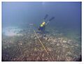
The USS ALLIGATOR' is the site of a U.S. Navy schooner that sank in 1822. It's an important archaeological site that helps us understand early American naval history.
USCG Cutter DUANE
The USCG Cutter DUANE' is a former U.S. Coast Guard ship that was intentionally sunk to create an artificial reef. It's now a popular spot for divers and a unique underwater historical site.

Other Unique Historic Sites
Monroe County has some truly one-of-a-kind historic places.
African Cemetery at Higgs Beach
The African Cemetery at Higgs Beach in Key West is a very important historical site. It's a burial ground for enslaved Africans who died after being rescued from illegal slave ships in the 1860s. It's a place for remembrance and learning about a difficult part of history.

African Queen (boat)
The African Queen is a famous boat from the classic movie of the same name, starring Humphrey Bogart and Katharine Hepburn. This historic boat is located in Key Largo and is a fun piece of movie history!

Sugarloaf Key Bat Tower
The Sugarloaf Key Bat Tower is a very unusual structure on Sugarloaf Key. It was built in 1929 to house bats, hoping they would eat mosquitoes. While it didn't quite work as planned, it's a quirky and interesting part of the Keys' history.

Florida Keys Memorial
The Florida Keys Memorial in Islamorada remembers the victims of the devastating 1935 Labor Day hurricane. This powerful storm caused a lot of damage and loss of life. The memorial is a place to reflect on the strength of nature and the resilience of the people of the Keys.

Indian Key State Historic Site
Indian Key is a small island that was once a thriving community and the first county seat of Dade County (which Monroe County was once part of). It was destroyed in an Indian attack in 1840. Today, it's a state historic site where you can explore the ruins and imagine what life was like there.

USCGC Ingham (WHEC-35)
The USCGC Ingham is a former U.S. Coast Guard ship that served for many years, including in World War II. It's now a museum ship in Key West, allowing visitors to step aboard and learn about Coast Guard history.

John Pennekamp Coral Reef State Park
John Pennekamp Coral Reef State Park in Key Largo was the first underwater park in the United States. It protects a beautiful part of the Florida Reef, including coral reefs and marine life. It's important for both its natural beauty and its role in conservation.

Key West Historic District
The Key West Historic District covers a large part of old Key West. It includes many of the historic homes, buildings, and streets that give Key West its unique charm. Walking through this district is like stepping back in time.

Lignumvitae Key State Botanical Park
Lignumvitae Key is a protected island that has a rare tropical hardwood hammock forest. It's an important archaeological and historical district, showing how people lived in the Keys long ago and preserving a unique natural environment.

Mud Lake Canal
The Mud Lake Canal is located in Everglades National Park. This canal is an important archaeological site, showing evidence of early human activity in the Everglades. It helps us understand how people used the land and water in the past.

Overseas Highway and Railway Bridges
The Overseas Highway is famous for connecting the islands of the Florida Keys. Many of its bridges were originally built for the Florida East Coast Railway by Henry Flagler. These bridges are amazing feats of engineering and are a vital part of the Keys' history and identity.

Pigeon Key Historic District
Pigeon Key is a small island near Marathon that was once a work camp for the construction of the Overseas Railway. It has several historic buildings that housed the workers. It's a great place to learn about the incredible effort it took to build the railway.

Veterans of Foreign Wars Walter R. Mickens Post 6021 and William Weech American Legion Post 168
This site in Key West represents the important role of veterans' organizations in the community. These posts have served as gathering places and support centers for veterans for many years.

Western Union (schooner)
The Western Union is a historic schooner, a type of sailing ship, docked in Key West. It was built in 1939 and was used to maintain telegraph cables. It's a beautiful example of a traditional sailing vessel and a piece of maritime history.

Archaeological Sites
Monroe County also has many important archaeological sites, which are places where scientists study human history through artifacts and remains.
Bear Lake Mounds Archeological District
This district in the Everglades is home to ancient mounds built by early people. These mounds can tell us a lot about how people lived in this area thousands of years ago.
Cane Patch
Another archaeological site in the Everglades, Cane Patch, provides clues about the lives of the indigenous people who lived there.
Rock Mound Archeological Site
This site near Key Largo is an archaeological "rock mound," which can be a burial site or a place used for ceremonies by ancient cultures.
Rookery Mound
Located in the Everglades, Rookery Mound is another archaeological site that helps researchers understand the history of human settlement and activity in the area.
Ten Thousand Islands Archeological District
This large district in the Everglades is a vast area with many archaeological sites, including shell mounds and other remains, showing the long history of human presence in the unique environment of the Ten Thousand Islands.

These are just some of the amazing historic places in Monroe County, Florida. Each one tells a unique story about the past, from ancient civilizations to famous writers and important battles. Visiting these sites helps us connect with history and understand how these places shaped the world we live in today.
Images for kids
-
African Cemetery at Higgs Beach
-

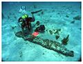
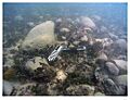
USS Alligator shipwreck site
-

El Gallo Indiano Shipwreck Site
-
El Rubi Shipwreck Site
-
Chaves Shipwreck Site
-
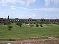
Fort Jefferson Courtyard
-
Herrera Shipwreck Site
-
US Naval Station
-
Angustias Shipwreck Site
-
San Francisco Shipwreck Site
-
Sueco de Arizon Shipwreck Site

_Shipwreck_Site.jpg)
_Shipwreck_Site.jpg)


