
Imbabura Volcano facts for kids
Quick facts for kids Imbabura |
|
|---|---|

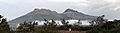
Imbabura, with sugarcane fields in the foreground.
|
|
| Highest point | |
| Elevation | 4,630 m (15,190 ft) |
| Prominence | 1,519 m (4,984 ft) |
| Listing | Ultra |
| Geography | |

Imbabura
Location in Ecuador
|
|
| Location | Imbabura Province, Ecuador |
| Parent range | Andes |
| Geology | |
| Mountain type | Inactive stratovolcano |
| Last eruption | 5550 BCE ± 500 years |
Imbabura is a large, inactive volcano in northern Ecuador. It is known as a stratovolcano because it has a cone shape. This shape is built up over time by many layers of hardened lava and ash.
Even though Imbabura has not erupted for at least 14,000 years, scientists do not think it is completely extinct. This means it could possibly erupt again in the future. The top of Imbabura is covered with snow, but it does not have any permanent glaciers.
The volcano's slopes are covered in volcanic ash. This ash makes the soil very fertile. Farmers in the region grow important crops like maize (corn), sugarcane, and beans. Raising cattle is also a very important activity for the local economy.
Location and Features
Imbabura is located in the Imbabura Province of Ecuador. It is part of the large Andes mountain range. The volcano stands tall at 4,630 meters (about 15,190 feet) above sea level. Its height makes it a very noticeable landmark in the area.
The volcano's last known eruption was around 5550 BCE. This was about 7,500 years ago. Even though it is inactive, its presence shapes the landscape and local life.
Local Life Around Imbabura
The land around Imbabura is very important for farming. The rich volcanic soil helps many plants grow well. This supports the local communities living near the volcano.
People in the Imbabura Province have a strong connection to the land. They use the fertile soil to grow food and raise animals. This helps them live and work in the shadow of the large volcano.
Images for kids
-
Imbabura Volcano seen from San Pablo del Lago
See also
 In Spanish: Volcán Imbabura para niños
