
Imbabura Province facts for kids
Quick facts for kids
Imbabura
|
|||
|---|---|---|---|
|
Province
|
|||
| Province of Imbabura | |||

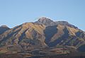
Mount Imbabura from south-east.
|
|||
|
|||

Imbabura Province in Ecuador
|
|||

Cantons of Imbabura Province
|
|||
| Country | |||
| Capital | Ibarra | ||
| Area | |||
| • Total | 4,587.51 km2 (1,771.25 sq mi) | ||
| Population
(2010 census)
|
|||
| • Total | 398,244 | ||
| • Density | 86.81049/km2 (224.8381/sq mi) | ||
| Time zone | ECT | ||
| Vehicle registration | I | ||
| HDI (2017) | 0.747 high · 7th |
||


Imbabura is a special area in northern Ecuador. It's like a state or region. You can find it high up in the Andes mountains.
The main city and capital of Imbabura is called Ibarra. People in this province speak Spanish. Many also speak Imbaburan Quechua, an old local language.
One of the coolest natural spots is the Cotacachi Volcano. Its top is super high, about 4,944 meters (16,220 feet) tall! It's located near the town of Cotacachi.
What are Cantons?
Imbabura Province is split into six smaller areas. These areas are called cantons. Think of them like counties or districts within a state. Each canton has its own main town or capital city.
The table below shows you each canton. It also tells you how many people lived there in 2010. You can also see how big each canton is in square kilometers.
| Canton | People (2010) | Area (km²) | Main Town |
|---|---|---|---|
| Antonio Ante | 43,518 | 81 | Atuntaqui |
| Cotacachi | 40,036 | 1,726 | Cotacachi |
| Ibarra | 181,175 | 1,093 | Ibarra |
| Otavalo | 104,874 | 500 | Otavalo |
| Pimampiro | 12,970 | 437 | Pimampiro |
| San Miguel de Urcuquí | 15,671 | 779 | Urcuquí |
Images for kids
-
Cotacachi volcano as seen from the town of Cotacachi.

See also
 In Spanish: Provincia de Imbabura para niños
