Indian Heights, Indiana facts for kids
Quick facts for kids
Indian Heights, Indiana
|
|
|---|---|

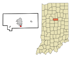
Location in the state of Indiana
|
|
| Country | United States |
| State | Indiana |
| County | Howard |
| Area | |
| • Total | 0.9 sq mi (2.2 km2) |
| • Land | 0.9 sq mi (2.2 km2) |
| • Water | 0.0 sq mi (0.0 km2) |
| Elevation | 856 ft (261 m) |
| Population
(2010)
|
|
| • Total | 3,011 |
| • Density | 3,807/sq mi (1,469.9/km2) |
| Time zone | UTC-5 (EST) |
| • Summer (DST) | UTC-4 (EDT) |
| FIPS code | 18-36144 |
| GNIS feature ID | 0436762 |
Indian Heights is a neighborhood located in Kokomo, Howard County, Indiana, in the United States. Before 2012, it was known as a census-designated place (CDP). This means it was an area identified by the government for collecting population data, but it wasn't officially a city or town.
In 2010, about 3,011 people lived in Indian Heights. On January 1, 2012, Indian Heights officially became part of the city of Kokomo. This process is called annexation.
Indian Heights has a park called Mohawk Park. There is also a playground at Taylor Elementary School. Some neighborhoods in Indian Heights are named after Native American tribes, like Ojibway, Miami, Algonquin, and Mohawk.
Contents
Where is Indian Heights Located?
Indian Heights is found at coordinates 40.428737 degrees North and 86.118540 degrees West. It covers an area of about 0.9 square miles (2.2 square kilometers). All of this area is land.
A Brief History of Indian Heights
Indian Heights was built in 1956 by Lusk Corporation and U.S. Steel. For many years, it was a community that grew quickly but was not officially part of any city.
When Kokomo annexed Indian Heights in 2012, the neighborhood started getting emergency services, like police and fire, from Kokomo instead of the county. Even though it's now part of Kokomo, students in Indian Heights still attend Taylor Schools. This is because the neighborhood is part of Taylor Township.
After being annexed, Indian Heights could no longer be a census-designated place (CDP). A CDP cannot be an official city or town. It also needs to be right next to an official city or have clear natural borders. Other places like New London, Jerome, or Sycamore might become CDPs in the future.
Who Lives in Indian Heights?
In 2000, there were 3,274 people living in Indian Heights. These people lived in 1,213 households, and 930 of these were families. The population density was about 3,802.5 people per square mile.
Most people living there were White (94.65%). About 2.84% were African American, and 0.34% were Native American. About 2.44% of the population identified as Hispanic or Latino.
Many households (38.7%) had children under 18 living with them. About 57.8% were married couples. The average household had 2.70 people, and the average family had 3.10 people.
The population was quite mixed in age. About 30.4% were under 18 years old. The median age was 33 years. This means half the people were younger than 33, and half were older.
The average income for a household was $45,444. For families, it was $50,128. About 4.6% of the people lived below the poverty line.
Getting Around Indian Heights
Since mid-2013, Indian Heights has been part of the Kokomo City-Line Trolley system. This trolley helps people travel around the city. Indian Heights is on the southern part of the Red Line route.
Major Roads and Highways
Several important roads pass through or near Indian Heights:
 SR 26: This road goes west to Lafayette and east to Hartford City.
 SR 931: This road goes north to Kokomo and south to Indianapolis.
See also
 In Spanish: Indian Heights (Indiana) para niños
 | Janet Taylor Pickett |
 | Synthia Saint James |
 | Howardena Pindell |
 | Faith Ringgold |

