
India–Pakistan border facts for kids

The Hindustan–Pakistan Border is a long line that separates India and Pakistan. People often call it the International Border (IB). This border divides Indian states like Punjab, Rajasthan, and Gujarat from Pakistani provinces like Punjab and Sindh. However, the region of Kashmir is different because its border is disputed. This border was created in 1947 when India was divided into two separate countries.
The town of Wagah is a special place along this border. It's where people can cross between India and Pakistan. Wagah is located between the Indian city of Amritsar and the Pakistani city of Lahore.
Contents
Understanding the Border Lines
The border between India and Pakistan has different names depending on the area. It's called an international border from Gujarat and Sindh up to the region of Kashmir.
The Line of Control in Kashmir
The Kashmir region is divided by a ceasefire line that was set up in 1949 by the United Nations. Since 1972, the actual border that separates Pakistan-administered Kashmir from Indian-administered Kashmir has been known as the Line of Control. This line is not an official international border.
The Working Boundary
South of the Line of Control, in the Jammu Division, is the border with Pakistan's Punjab province. Pakistan calls this part the working boundary. India, however, considers this entire line to be an "international border." This term "working boundary" is a newer name used by Pakistan.
Other Border Issues
Sometimes, there are disagreements about certain parts of the border. These are some of the areas that have been discussed:
- The Rann of Kutch and the Kori Creek areas.
- Parts of the Ferozpur District.
- The Pathankot Tehsil area.
Images for kids
-
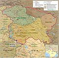
Map of the Kashmir region showing the Line of Control (LoC) and the Working Boundary between India and Pakistan.
-
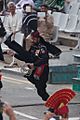
Wagah border ceremony, 2015.
-
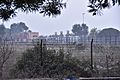
India-Pakistan border at Wagah, 2017.
.jpg)


See also
 In Spanish: Frontera entre Pakistán e India para niños
