Ingleton Waterfalls Trail facts for kids
Quick facts for kids Ingleton Waterfalls Trail |
|
|---|---|

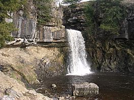
Thornton Force
|
|
| Length | 8 km (5.0 mi) |
| Location | Ingleton, North Yorkshire, England |
| Trailheads | Ingleton, North Yorkshire (circular) |
| Use | Hiking |
| Highest point | 285 metres (934 ft) |
| Difficulty | Easy to Moderate |
| Season | All year |
| Maintained by | Ingleton Scenery Company Limited |
The Ingleton Waterfalls Trail is a famous circular walking path in the village of Ingleton, North Yorkshire, England. It's looked after by the Ingleton Scenery Company. This amazing trail is about 8 kilometers (5 miles) long. It climbs about 169 meters (554 feet) in height. Many people say it has some of the most beautiful waterfalls and forest views in northern England. The trail is on private land, so you need to pay a small fee to enter.
Contents
Discovering the Trail
The Ingleton Waterfalls Trail was created because people became very interested in the area's natural beauty. Local newspapers, like the Lancaster Guardian, published articles about the stunning scenery around Ingleton. This made people want to explore places that were once hidden.
To make the area accessible, new paths and bridges were built. The trail officially opened on Good Friday, April 11, 1885. The nearby Ingleton railway station was a big reason for the trail's early success. It brought many visitors from cities like Bradford, Manchester, and Leeds.
Exploring the Geology
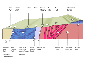
Ingleton is located on a special geological feature called the North and South Craven fault. This fault exposes very old rocks, including Carboniferous and Ordovician types. There's even a mysterious rock type called "Ingletonian" rock, which scientists have classified as Ordovician. This means it formed hundreds of millions of years ago!
Walking the Waterfalls Trail
The adventure begins at the Broadwood car park. The trail guides you along the banks of the River Twiss. You'll pass through a lovely area called Swilla Glenn. Here, you might spot a unique "coin embedded tree," where people have pressed coins into the bark for good luck.
As you continue, you'll reach several beautiful waterfalls:
- Pecca Falls
- Pecca Twin Falls
- Holly Bush Spout
- Thornton Force
After enjoying these sights, a footbridge crosses the River Twiss. The path then leads you to Twistleton Lane, which climbs out of the valley to a height of about 934 feet (285 meters). You'll follow Twistleton Lane past Scar End Farm and Twistleton Hall. Then, you'll cross Oddies Lane to reach Beezley's Farm.
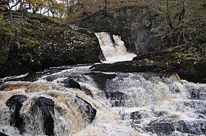
After Beezley's, the trail starts to go downhill along the banks of the River Doe. This river starts near God's Bridge, close to the village of Chapel-le-Dale. It flows gently until it reaches the waterfalls part of the walk. Here, you'll see Beezley's Falls Triple Spout, which has three waterfalls flowing side-by-side.
As you keep going, you'll look down 18 meters (59 feet) onto Rival Falls. Then, you'll see Baxenghyll Gorge and Snow Falls. Finally, you'll walk through Twistleton Glen and make your way back to Ingleton village.
In Ingleton, the River Twiss and the River Doe meet. They form a new river called the River Greta. The River Greta then flows into the larger River Lune.
Special Nature Area
The areas around the River Twiss and River Doe on the Waterfalls Trail are very special. English Nature has named them a Site of Special Scientific Interest (SSSI). This is because they have interesting plants, animals, and unique geological features. It's a great place to learn about nature!
 | May Edward Chinn |
 | Rebecca Cole |
 | Alexa Canady |
 | Dorothy Lavinia Brown |


