
River Twiss facts for kids
Quick facts for kids River Twiss |
|
|---|---|

River Twiss and Ingleton Viaduct
|
|
| Country | England |
| Physical characteristics | |
| Main source | Kingsdale Beck, Keld Head 264 metres (866 ft) 54°11′3″N 2°28′4″W / 54.18417°N 2.46778°W |
| River mouth | River Doe 118 metres (387 ft) 54°9′11″N 2°28′15″W / 54.15306°N 2.47083°W |
| Length | 4.17 kilometres (2.59 mi) |
The River Twiss is a small but interesting river in Yorkshire, England. It starts as Kingsdale Beck, which flows from a place called Kingsdale Head. This is where two smaller streams, Back Gill and Long Gill, meet up.
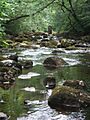
After flowing past Keld Head, Kingsdale Beck changes its name to the River Twiss. This river is famous for its two amazing waterfalls, Thornton Force and Pecca Falls. The river's path is part of the popular Ingleton Waterfalls Walk. It then flows through a beautiful area called Swilla Glen, past Thornton in Lonsdale, and down to the village of Ingleton. In Ingleton, the River Twiss joins another river, the River Doe, to form the River Greta.
Did you know that a famous English artist, J. M. W. Turner, visited this area often? He even sketched Thornton Force in 1816, and his drawing is now kept in the Tate art collection!
Contents
Where Does the River Twiss Flow?
The River Twiss begins its journey from caves found below Keld Head. Water flows out from these caves and joins Kingsdale Beck, which then becomes the River Twiss.
The river flows south, creating the stunning Thornton Force and Pecca Falls. It continues its path through lovely woodlands. Finally, it meets the River Doe in Ingleton, marking the end of its short but exciting journey.
Discover the Waterfalls: Thornton Force and Pecca Falls
The River Twiss is well-known for its beautiful waterfalls.
- Thornton Force: This impressive waterfall drops about 14 metres (46 ft) (around 46 feet) down a rocky cliff. It's a popular spot for visitors.
- Pecca Falls: Just a bit further along the river, Pecca Falls is actually three separate drops. Together, these drops fall about 30 metres (98 ft) (nearly 100 feet) into deep pools below.


What Kind of Rocks Does the River Flow Over?
The River Twiss flows over different types of rocks. In its upper parts, it cuts through flat layers of a rock called Carboniferous Great Scar limestone.
At Thornton Force, you can see something special called an "unconformity." This is where the river crosses from one type of rock to a much older, tilted rock called Ordovician greywacke. You can clearly see this change in the rock layers right at the waterfall!
The older, tilted rocks make the Swilla Glen area, with its waterfalls, very steep and narrow. Closer to Ingleton, the river crosses a major crack in the Earth's crust called the Craven Fault. After this, it flows over Carboniferous Limestone again.
Bridges Over the River Twiss
Several bridges cross the River Twiss, mostly for people walking along the popular trails:
- Ravenray Bridge (for walkers)
- Pecca Bridge (for walkers)
- Manor Bridge (for walkers)
- An unnamed road bridge in Ingleton
Images for kids
-
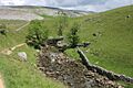
The River Twiss near Raven Ray footbridge.
-
Manor Bridge crossing the River Twiss.
-
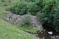
Cuckoo Island in the River Twiss.
-
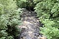
The River Twiss seen from a road bridge in Ingleton.


