
Inishmeane facts for kids
|
Native name:
Inis Meáin
|
|
|---|---|

Inishmeane from Magheragallon Cemetery
|
|

Inishmeane
Location in island of Ireland
|
|
| Geography | |
| Location | Atlantic Ocean |
| Coordinates | 55°06′15″N 8°20′46″W / 55.10417°N 8.34611°W |
| Area | 0.473 km2 (0.183 sq mi) |
| Administration | |
| Province | Ulster |
| County | Donegal |
| Demographics | |
| Population | 7 (2011) |
Inishmeane (which means "middle island" in Irish) is a small island located off the coast of Gweedore in County Donegal, Ireland. It used to be a busy place with many fishing families. For many years, no one lived on the island. However, recently, some people have started to move back or use homes there for holidays.
Contents
Island Location and Size
Inishmeane is a small island, about 1 kilometre (or 0.6 miles) away from the coast of Gweedore. It sits in the Atlantic Ocean. If you look at a map, you'll find it between two other islands: Gola Island to its southeast and Inishsirrer to its north. The island itself is quite small, covering an area of about 0.473 square kilometres.
A Look at Inishmeane's Past
People lived on Inishmeane for a long time, but by the 1960s, most residents had moved away. This meant many of the buildings on the island became empty and fell into disrepair. Today, you can still see many old, unused buildings. However, about eight of these old houses have been fixed up. Some are now used as holiday homes, while others have become permanent homes for a few people.
Life on Inishmeane is quite simple. The island does not have public electricity or a public supply of fresh water. This means residents often rely on other ways to get power and water. During a time known as the "Celtic Tiger" (a period of fast economic growth in Ireland), a concrete pier was built on the island. This pier makes it easier for boats to dock, helping people travel to and from the mainland.
Who Lives on Inishmeane?
The number of people living on Inishmeane has changed a lot over the years. In the mid-1800s, the population was small, but it grew to over 80 people by 1911. After that, the number of residents slowly started to decrease. By the 1970s, no one lived on the island at all. It remained unpopulated for many years. However, in 2011, the census showed that 7 people had returned to live on Inishmeane. This shows a small but interesting change for the island.
Images for kids
-
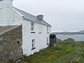
A house on Inishmeane island.

