Iran–Pakistan border facts for kids
Quick facts for kids Iran–Pakistan border |
|
|---|---|
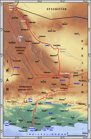
Map showing the international boundary between Iran and Pakistan in red
|
|
| Characteristics | |
| Entities | |
| Length | 909 kilometres (565 mi) |
| History | |
| Established | 1905 (current state) (British Empire and Qajar Iran) |
| Notes | See Iran–United Kingdom relations for historical demarcation details |
The Iran–Pakistan border is a long line that separates the countries of Iran and Pakistan. It marks the end of Iran's Sistan and Baluchestan and the start of Pakistan's Balochistan province. This border stretches for about 909 kilometers (565 miles).
Contents
What is the Iran–Pakistan Border Like?
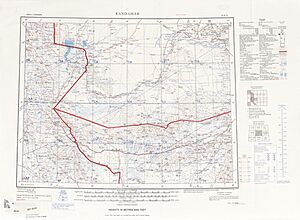
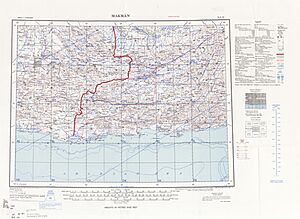
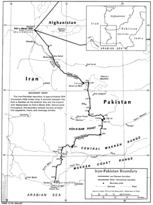
The border starts where Iran, Pakistan, and Afghanistan meet at a mountain called Kuh-i-Malik Salih. From there, it goes southeast in a straight line. It then follows mountains, small rivers that dry up, and the Tahlab River.
Further south, the border makes sharp turns. It goes along more mountains to the Mashkil River. It follows this river south, then the Nahang River west. Finally, it crosses land over mountains and straight sections. The border ends at Gwadar Bay in the Gulf of Oman, which is part of the Arabian Sea.
How the Iran–Pakistan Border Was Created
This border cuts through a region called Balochistan. This area has been important to different empires for a long time. In the 18th century, the British slowly took control of most of India. This included the land that is now Pakistan. This brought them close to areas that Persia (now Iran) traditionally claimed.
In 1871, the British and Persians decided to draw a clear line for their border. A group of experts surveyed the area in 1872. They mapped the border but did not mark it on the ground. Some small problems with the border line were fixed in a new agreement in 1905.
In 1947, the British left, and Pakistan became an independent country. Iran and Pakistan then officially agreed on their shared border in 1958–59. They fully mapped the area and put up pillars to mark the border on the ground.
Border Fences and Walls
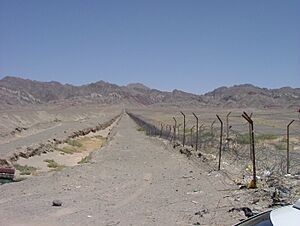
Both Iran and Pakistan have built fences and walls along parts of their shared border. These barriers help control who crosses the border. They also aim to stop illegal trade and prevent terror attacks.
Iran's Fencing Project
Around 2011, Iran started building a strong concrete wall. It is about 91 centimeters (3 feet) thick and 3.05 meters (10 feet) high. This wall is strengthened with steel rods. It was planned to cover about 700 kilometers of the border.
The project also includes large earth walls and deep ditches. These are meant to stop illegal crossings. The border area already has police towers and forts for soldiers. Iran and Pakistan do not have disagreements over the border itself. Pakistan's government said Iran had the right to build the fence on its own land.
Some people in the Provincial Assembly of Balochistan did not like the wall. They said it would cause problems for local people. Many families live on both sides of the border. They worried the wall would divide them and make trade harder. An opposition leader asked the governments to talk to the local people. He also asked them to stop building the wall.
Pakistan's Fencing Project
In 2019, Pakistan also announced it would fence its border with Iran. By mid-2021, Pakistan had finished almost half of its border fence. They planned to finish the project by December 2021. By January 2022, Pakistan had fenced 80% of the border. The government plans to fence the rest of the border sections.
Border Crossings and Markets
The Frontier Corps looks after border security and immigration on Pakistan's side. In Iran, the Iranian Revolutionary Guards are in charge of border security.
Pakistan and Iran have four official places where people and goods can cross the border.
- Taftan and Gabd are for both people and trade.
- Mand and Chadgi are only for trade.
Because Iran drives on the right side of the road and Pakistan drives on the left, cars must change sides at the border crossings.
The two countries have also agreed to open six joint border markets. These markets will help increase trade between them. The first three markets are now open at Gabd, Mand, and Chadgi.
Road Crossings
| # | Crossing | Counterpart | Road | Province | Opened | Purpose | Status |
|---|---|---|---|---|---|---|---|
| 1 | Taftan | Mirjaveh | N-40 - Road 84 | Balochistan-Sistan Balochistan | Miscellaneous | Operational | |
| 2 | Gabd (Gwadar) | Chabahar (Rimdan) | N-10 - Bahukalat Protected Area Road | 20.12.2020 | Miscellaneous | Operational | |
| 3 | Mand | Pishin | Turbat - Road 92 | 21.04.2021 | Trade | Operational | |
| 4 | Chadgi | Kuhak | Pishin-Kurumb road | Trade | Operational |
Rail Crossings
- Taftan / Mirjaveh, on the train line between Quetta and Zahedan.
Towns Near the Border
Iran
- Lar Marud
- Zahedan
- Kacheh Rud
- Mirjaveh
- Ladiz
- Narreh Now
- Jaleq
- Kalleh
- Fahreh
- Murt
- Esfandak
- Kavari
- Pishin
- Kushak
Pakistan
- Sohtagan
- Qila Ladgasht
- Washap
- Sar-i Parom
- Girbum
- Sohrag
- Abdui
- Taftan
- Sirag
- Kurumb
- Jiwani
See also
 In Spanish: Frontera entre Irán y Pakistán para niños
- Iran–Pakistan relations
 | Calvin Brent |
 | Walter T. Bailey |
 | Martha Cassell Thompson |
 | Alberta Jeannette Cassell |


