
Sistan and Baluchestan province facts for kids
Quick facts for kids
Sistan and Baluchestan province
استان سیستان و بلوچستان
|
|
|---|---|

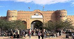
Sib and Suran Castle
|
|

Map of Iran with Sistan and Baluchestan province highlighted
|
|
| Country | Iran |
| Capital | Zahedan |
| Counties | 26 |
| Area | |
| • Total | 180,726 km2 (69,779 sq mi) |
| Population
(2016)
|
|
| • Total | 2,775,014 |
| • Density | 15.35481/km2 (39.76878/sq mi) |
| Demonym(s) | Baloch |
| Time zone | UTC+03:30 (IRST) |
| Main language(s) | Baluchi Persian |
| HDI (2017) | 0.688 medium · 31st |
Sistan and Baluchestan province is a large area in the southeast of Iran. It is the second biggest province in Iran, covering about 180,726 square kilometers. This province shares borders with Pakistan and Afghanistan. Its capital city is Zahedan.
In 2016, about 2.7 million people lived here. Most people in the province are Baloch, and they speak the Baluchi language. There are also Sistani people who speak a dialect of Persian.
Contents
History of Sistan and Baluchestan
The name Sistan comes from an ancient tribe called the Saka. They took control of this area a very long time ago, around 128 BC. Sistan was an important eastern territory during the time of Darius the Great, a famous Persian king.
Later, during the Arsacid Dynasty, Sistan became a powerful center. It continued to grow and thrive until the early Islamic period. Around 644 AD, Arab Muslims took control as the Persian Empire was ending.
A famous Persian ruler named Ya'qub-i Laith Saffari later became the governor of this area. His family ruled for many centuries. Other powerful groups like the Seljuqids also ruled parts of this land. In 1508 AD, Shah Ismail I of the Safavid family conquered Sistan.
After 1747, Sistan and Balochistan became part of the Brahui Khanate of Kalat. It later joined Qajar Iran.
Geography and Climate

The province was once called only Baluchestan. After the 1979 revolution, the government added Sistan to its name. Today, Sistan is the northern part of the province, and Baluchestan covers the area from Zahedan to Chabahar.
The province borders South Khorasan province to the north and Kerman province and Hormozgan province to the west. To the south, it meets the Gulf of Oman. To the east, it borders Afghanistan and Pakistan.
Sistan and Baluchestan is one of the driest places in Iran. It gets a little more rain towards the west. The coastal areas near the Gulf of Oman are more humid. Strong seasonal winds blow through the province. One famous wind is the "120-day wind" of Sistan, known as Levar in Baluchi.
Cities and Population

The province is divided into different areas called counties. Many people live in cities. In 2016, over 48% of the province's population lived in its cities.
The capital and largest city is Zahedan, with over 587,000 people. Other important cities include Zabol, Iranshahr, and Chabahar.
Largest Cities
Here are the ten largest cities in Sistan and Baluchestan province:
| Rank | Name | Population (2016) |
|---|---|---|
| 1 | Zahedan | 587,730 |
| 2 | Zabol | 134,950 |
| 3 | Iranshahr | 113,750 |
| 4 | Chabahar | 106,739 |
| 5 | Saravan | 60,014 |
| 6 | Khash | 56,584 |
| 7 | Konarak | 43,258 |
| 8 | Jaleq | 18,098 |
| 9 | Nik Shahr | 17,732 |
| 10 | Pishin | 16,011 |
People and Languages

Most people in Sistan and Baluchestan are Baloch. They speak the Baluchi language. There is also a smaller group of people called Sistani, who speak a dialect of Persian.
Religion
The Sistani people in the province are Shia Muslims. Most of the Baloch people in the Baluchestan area are Sunni Muslims.
Economy and Industry

Industry is quite new to this province. The government is working to bring more businesses here. They offer tax breaks and other help to encourage new factories and jobs.
Important factories include the Khash cement factory, which makes 2,600 tons of cement every day. Other cement factories are also being built. There are also factories that make cotton cloth, fishing nets, and bricks.
The province has many valuable natural resources. These include metals like chrome, copper, granite, antimony, and even gold and silver. One important mine is the Chel Kooreh copper mine, located north of Zahedan.
Sistan embroidery is a very old craft from this region. It has been around since the 5th century BC!
Transportation
Railways
The city of Zahedan has been connected to Quetta in Pakistan by a railway for about a hundred years. There are weekly trains to Quetta. A new railway line from Bam, Iran to Zahedan has also opened. There are plans to build more railway lines, including one from Zahedan to Chabahar.
Airports

Sistan and Baluchestan province has two main airports for passengers:
- Zahedan Airport
- Chabahar Airport (also known as Konarak Airport)
Ports
The Port of Chabahar is the main port in the south of the province. It is a very important port and is being connected to Zahedan by a new railway. India is helping to invest in this port. The port is located on the Coast of Makran, about 70 kilometers west of Gwadar in Pakistan.
Higher Education
The province has several universities and higher education centers:
- University of Sistan and Baluchestan
- Chabahar Maritime University
- Zabol University
- Islamic Azad University of Iranshahr
- Islamic Azad University of Zahedan
- Zahedan University of Medical Sciences
- Zabol University of Medical Sciences
- International University of Chabahar
- Velayat University of Iranshahr
- Jamiah Darul Uloom Zahedan
Landmarks
The province is home to several historical castles, such as the Firuzabad Castle, Rostam Castle, and the Naseri Castle.
-
Naseri Castle, Iranshahr
-
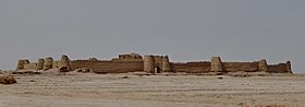
Rostam Castle, in Hamun County


Images for kids
-
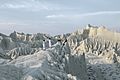
Mountains in Chabahar County

See also
 In Spanish: Provincia de Sistán y Baluchistán para niños
- Bazman, volcano mountain
- Baloch people
- Sistan region
- Balochistan region
- Balochistan, Afghanistan
- Balochistan, Pakistan
