
Kerman province facts for kids
Quick facts for kids
Kerman province
Persian: استان کرمان
|
|
|---|---|

Bam Fortress (2016)
|
|

Location of Kerman province within Iran
|
|
| Country | |
| Region | Region 5 |
| Capital | Kerman |
| Counties | 25 |
| Area | |
| • Total | 183,285 km2 (70,767 sq mi) |
| Elevation | 192 m (630 ft) |
| Population
(2016)
|
|
| • Total | 3,164,718 |
| • Density | 17.26665/km2 (44.72042/sq mi) |
| Time zone | UTC+03:30 (IRST) |
| Main language(s) | Persian |
| HDI (2017) | 0.778 high · 20th |
| Website | www.gov.kr.ir |
Kerman province (Persian: استان کرمان, Ostān-e Kermān) is the largest of Iran's 31 provinces. It is located in the southeast part of Iran. The capital city of Kerman province is Kerman. In 2014, it became part of Region 5 of Iran.
Long ago, this area was known as Carmania during the Achaemenid Empire. Kerman province covers a huge area of about 183,285 square kilometers (70,767 sq mi). This means it makes up almost 11% of all the land in Iran!
In 2016, about 3.16 million people lived in Kerman province. The capital city, Kerman, is home to about 537,718 people. It is the biggest and most developed city in the province. Most people in Kerman province are Fars, but there are also many other Iranian groups. These include Lor, Kurd, Lak, Afshar-Turk, Jebal-Barezi, Zartoshti, Baluch, Larestani, Bandari, Pishdar, and Ghassemlou.
Contents
Geography and Landscape
Kerman province has many mountains that are part of Iran's central mountain ranges. These mountains stretch from Azarbaijan all the way to Baluchestan. They create large, flat plains across the province.
Mountain Ranges and Peaks
The Bashagard and Kuhbonan Mountains are some of the tallest in this region. They have high peaks like Toghrol, Aljerd, Palvar, Sirach, Abareq, and Tahrood. Other mountain ranges go from Yazd to Kerman. These include very high peaks like Hazaran, which is 4,501 meters (14,767 feet) above sea level. Another tall peak is Kuh-e Shah, at 4,402 meters (14,442 feet). Other notable mountains are Joupar, Bahr Aseman, and Khabr mountain in Khabr National Park.
Deserts and Oases
Most of Kerman province is either dry steppe land or sandy desert. However, there are special green areas called oases. In these oases, farmers grow delicious dates, oranges (which are said to be the best in Iran), and pistachios. Long ago, "Carmanian" wine was also famous for its great taste. To water their crops, people in the province use qanats. These are amazing underground channels that bring water from mountains to dry areas.
Natural Disasters
Kerman province can sometimes experience natural disasters. For example, a recent flood uncovered the ancient city of Jiroft in the south of the province. Sadly, Arg-é Bam, which was the world's largest adobe (mud-brick) structure, was destroyed by an earthquake in December 2003. Another big earthquake happened on February 22, 2005, near the town of Zarand. It caused a lot of damage and sadly, many people lost their lives.
History of Kerman Province
The history of Kerman province goes back a very long time.
Ancient Times
An old text from the 8th century, thought to be written by the Armenian historian Movses Khorenatsi, says that Kerman province was in the southern part of the Sasanian Empire. From the Sasanian era until the 10th century, the main city in this area was Sirjan. Early Muslim geographers described the region as very hot. They also mentioned that the mountainous areas were home to groups like the Kufečs.
Later Empires
In the 13th century, Kerman province was ruled by the Qutlugh-Khanids, who were from the Khitan group. After that, it became part of the huge Mongol empire. In the 15th century, the Timurid empire took control of the region.
Administrative Divisions and Cities
Kerman province is divided into smaller areas called counties. It has 25 counties. The capital city, Kerman, is the largest.

Most Populous Cities
Many people in Kerman province live in cities. Here are some of the largest cities by population:
| Rank | City | County | Population (2016) |
|---|---|---|---|
| 1 | Kerman | Kerman | 537,718 |
| 2 | Sirjan | Sirjan | 199,704 |
| 3 | Rafsanjan | Rafsanjan | 161,909 |
| 4 | Jiroft | Jiroft | 130,429 |
| 5 | Bam | Bam | 127,396 |
| 6 | Zarand | Zarand | 60,370 |
| 7 | Kahnuj | Kahnuj | 52,624 |
| 8 | Shahr-e Babak | Shahr-e Babak | 51,620 |
| 9 | Baft | Baft | 34,517 |
| 10 | Bardsir | Bardsir | 25,152 |
Languages Spoken
The main languages spoken in Kerman province are Persian and Garmsiri. There are also smaller groups who speak other languages. These include Achomi, different Turkic dialects, and a special dialect spoken by the Jewish and Zoroastrian communities. The different types of Persian spoken in Kerman are quite similar to Standard Persian, so people can easily understand each other.
Economy and Industry
Kerman province has a diverse economy.
Agriculture and Resources
A long time ago, around 1920, Kerman was known for its high-quality caraway spice. Today, Kerman is famous for its many pistachio fields. These fields are found in the city of Kerman itself and in nearby areas like Rafsanjan, Ravar, and Nooq. The Gol Gohar mine, which is the largest iron mine in Iran, is also located in Kerman province.
Modern Industries
Today, a big part of Iran's auto industry is based in Kerman. Sirjan is a special economic zone. This means it's an important place for bringing imported goods from the south, especially through the Persian Gulf. Arg e Jadid is another special economic zone in Kerman province. These zones help boost trade and business in the region.

Education and Universities
Kerman province is home to several important colleges and universities. These institutions offer higher education to students.
- Jiroft University
- Kerman University of Medical Sciences
- Rafsanjan University of Medical Sciences
- Shahid Bahonar University of Kerman
- Sirjan University of Technology
- ValiAsr University of Rafsanjan
Images for kids
-
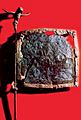
Bronze flag from Shahdad, Kerman, Iran, dating back to the 3rd millennium BC.
-
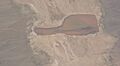
The Jazmoorian wetland, a significant natural feature.


See also
 In Spanish: Provincia de Kermán para niños
- Kirman (Sasanian province)
- Kerman province parliamentary districts
- List of monuments in Kerman province
- Carmania (satrapy)
- Dalfard
